Agua Fria River
Stream in Arizona, United States
34°37′00″N 112°23′56″W / 34.61667°N 112.39889°W / 34.61667; -112.39889[1] • location
• coordinates
• elevation
The Agua Fria River (Spanish for "cold water") is a 120-mile (190 km) long intermittent stream which flows generally south from 20 miles (32 km) east-northeast of Prescott in the U.S. state of Arizona. Prescott draws much of its municipal water supply from the upper Agua Fria watershed.[6] The Agua Fria runs through the Agua Fria National Monument. The river then flows through a small canyon called "Black Canyon" into Lake Pleasant, a popular recreation area near Peoria, Arizona. (There is a large "Black Canyon" on the Colorado River along the Arizona–Nevada border.)
During rainy weather and at times when water is flowing in the intermittent Agua Fria River, it discharges into the Gila River, which also only flows during wet periods of the year.
The Central Arizona Water Conservation District of the Central Arizona Project operates the Agua Fria Recharge Project, which is about 4 miles (6.4 km) south of the New Waddell Dam. It serves to recharge underground aquifers in this area, and ends at Lake Pleasant, Phoenix.[7]
Variant names
According to the Geographic Names Information System, it has also been known historically as:[1]
- Agua Fria Creek
- Agua Frie
Course
The Agua Fria River rises about 1.5 miles northeast of Granite Dells, Arizona and then flows south to join the Gila River about 1 mile south of Goodyear, Arizona.[3]
Watershed
Agua Fria River drains 2,433.70 square miles (6,303.3 km2) of area, receives about 16.4 in/year of precipitation, has a wetness index of 415.05, and is about 11% forested.[5]
-
 Agua Fria Canyon, near Richinbar Mine, Agua Fria National Monument
 -
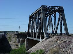 The historic Agua Fria River Bridge was built by the Santa Fe Railroad over the Agua Fria River in 1895. It is located on the right side of Grand Avenue traveling from Phoenix to Wickenburg, close to 111th Ave. in El Mirage.


See also
References
- ^ a b c "GNIS Detail – Agua Fria River". geonames.usgs.gov. US Geological Survey. Retrieved 16 June 2021.
- ^ "Get Maps". USGS Topoview. US Geological Survey. Retrieved 16 June 2021.
- ^ a b "Get Maps". USGS Topoview. US Geological Survey. Retrieved 16 June 2021.
- ^ "ArcGIS Web Application". epa.maps.arcgis.com. US EPA. Retrieved 16 June 2021.
- ^ a b c "Agua Fria River Watershed Report". US EPA Geoviewer. US EPA. Retrieved 16 June 2021.
- ^ Upper Agua Fria Basin Archived September 27, 2006, at the Wayback Machine
- ^ Agua Fria Recharge Project Archived January 17, 2008, at the Wayback Machine
External links
Wikimedia Commons has media related to Agua Fria River.
- Maricopa Audubon Society Page on the Agua Fria Wildlife Preserve
- Agua Fria River Master Plan[permanent dead link], by Maricopa County
- Agua Fria – New River Natural Resource Conservation District
- Photos taken along the Agua Fria River
- Bureau of Land Management Page on the Agua Fria National Monument
- v
- t
- e
- Agua Sal Creek
- Black Creek
- Black River
- Blue River
- Chinle Creek
- Chinle Wash
- Kinlichee Creek
- Laguña Creek
- Little Colorado River
- Puerco River
- San Francisco River
- Walker Creek
- Zuni River
- Babocomari River
- Black Draw
- Bonita Creek
- Dragoon Wash
- Mescal Arroyo
- San Bernardino River
- San Pedro River
- San Simon River
- Steins Creek
- Tres Alamos Wash
- Whitewater Draw
- Canyon Creek
- Canyon Creek
- Cherry Creek
- Christopher Creek
- East Verde River
- Fossil Creek
- Gila River
- Haigler Creek
- Horton Creek
- Negro Wash
- Salome Creek
- Salt River
- Tonto Creek
- White River
- Workman Creek
- Aravaipa Creek
- Ash Creek
- Black River
- Gila River
- San Pedro River
- San Simon River
- Black River
- Blue River
- Eagle Creek
- San Francisco River
- Bouse Wash
- Colorado River
- Santa Maria River
- Tyson Wash
- Agua Fria River
- Centennial Wash
- Gila River
- Hassayampa River
- Salt River
- Verde River
- Beaver Dam Wash
- Big Sandy River
- Bill Williams River
- Centennial Wash
- Colorado River
- Diamond Creek
- Kingman Wash
- Sacramento Wash
- Santa Maria River
- Virgin River
- Black River
- Chevelon Creek
- Cibecue Creek
- Clear Creek
- Laguña Creek
- Little Colorado River
- Little Lithodendron Wash
- Puerco River
- Silver Creek
- White River
- Arivaca Creek
- Brawley Wash
- Ciénega Creek
- Mescal Arroyo
- Molino Creek
- Rillito River
- Sabino Creek
- San Cristobal Wash
- San Pedro River
- Santa Cruz River
- Tenmile Wash
- Gila River
- San Pedro River
- Santa Cruz River
- Tom Mix Wash
- Babocomari River
- Ciénega Creek
- Harshaw Creek
- Santa Cruz River
- Sonoita Creek
- Agua Fria River
- Fossil Creek
- Granite Creek
- Hassayampa River
- Verde River
Authority control databases | |
|---|---|
| International |
|
| National |
|


