Ainaro Municipality
Municipality of East Timor
You can help expand this article with text translated from the corresponding article in German. (November 2010) Click [show] for important translation instructions.
- View a machine-translated version of the German article.
- Machine translation, like DeepL or Google Translate, is a useful starting point for translations, but translators must revise errors as necessary and confirm that the translation is accurate, rather than simply copy-pasting machine-translated text into the English Wikipedia.
- Do not translate text that appears unreliable or low-quality. If possible, verify the text with references provided in the foreign-language article.
- You must provide copyright attribution in the edit summary accompanying your translation by providing an interlanguage link to the source of your translation. A model attribution edit summary is
Content in this edit is translated from the existing German Wikipedia article at [[:de:Ainaro (Gemeinde)]]; see its history for attribution. - You may also add the template
{{Translated|de|Ainaro (Gemeinde)}}to the talk page. - For more guidance, see Wikipedia:Translation.
Municipality of East Timor

Official map

medium · 12th
Ainaro (Portuguese: Município Ainaro, Tetum: Munisípiu Ainaru) is one of 13 municipalities of East Timor, in the southwest part of the country. It has a population of 59,175 (census 2010) and an area of 804 km2.[2] Its capital is the city of Ainaro, a small mountain town.
Etymology
The name of the municipality is derived from 'Ai Naruk', the local Mambai language word for "tall tree", and refers to a species of tree that grows in the region. Ainaro is a Portuguese approximation of Ainaru, the Mambai and Tetum derivation.[3]
The traditional name of the region, 'Orluli', is still used today by Lian Nain [de] during ceremonies, such as the sergala, to greet important guests.[4]
Geography
Ainaro has a great abundance of rivers and fertile terrain for agriculture. It has a coastal area, on the Timor Sea, but also mountainous zones, including the highest point in East Timor, Mount Ramelau (2,960 m), also known as Tatamailau, which lies near the border with Ermera.
The borders of the municipality are identical to that of the same in Portuguese Timor, with the following exceptions: during the Indonesian occupation, the then subdistrict of Turiscai became part of Manufahi from Ainaro, and the then subdistrict of Hato-Udo became part of Ainaro in exchange. The then subdistrict of Mape-Zumalai became part of Cova Lima in 2003.
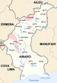
The municipality borders Aileu to the north, Manufahi to the south, Cova Lima to the southwest, Bobonaro to the west, and Ermera to the northwest.
-
 Borders of Ainaro before 2003
 -
 Borders of Ainaro after 2003
 -
 Cities and rivers of Ainaro


History
Ainaro played an important role during the brutal Indonesian occupation of East Timor, providing shelter for the mountain-based guerrilla resistance army. Former guerrilla leader, former President, and current Prime Minister Xanana Gusmão spent many years directing the resistance from Ainaro.
Administrative posts
The municipality's administrative posts (formerly sub-districts) are:[5]
- Ainaro administrative post (place of capital Ainaro)
- Hato-Udo Administrative Post
- Hatu-Builico Administrative Post
- Maubisse Administrative Post
Demographics
62.4 % of the population speaks Mambai as mother tongue, 29.1 % Tetum and 7.5 % Bunak. 400 persons are speaking Kemac. 99.1 % are Catholics, 0.9 % protestants, 0.03 % Muslim and only 19 persons are following still the traditional beliefs (census 2015).
References
Notes
- ^ "Sub-national HDI - Area Database - Global Data Lab". hdi.globaldatalab.org. Retrieved 13 September 2018.
- ^ "Rezumu hosi Rezultadu Prinsipál Sensu 2010 iha Timor-Leste" (PDF). La'o Hamutuk. 2011. Retrieved 22 February 2017.
- ^ Hull, Geoffrey (June 2006). "The placenames of East Timor" (PDF). Placenames Australia: Newsletter of the Australian National Placenames Survey: 6–7. Archived from the original (PDF) on 14 February 2017. Retrieved 25 April 2022.
- ^ "Perfil: 2. Toponímia" [Profile: 2. Toponymy]. Ainaro Municipality (in Tetum). Retrieved 18 July 2022.
- ^ Gunn, Geoffrey C (2011). Historical Dictionary of East Timor. Lanham, Maryland: Scarecrow Press. p. 36. ISBN 9780810867543.
Bibliography
- Ainaro District Development Plan 2002 - 2003 (PDF) (Report). April 2002. Archived from the original (PDF) on 28 March 2009. Retrieved 27 February 2022.
- Munisipio Ainaro: Planu Estartejiku Desenvolvimentu Munisipal [Ainaro Municipality: Municipal Strategic Development Plan] (Report) (in Tetum). Ministry of State Administration (East Timor) / Administration of Ainaro Municipality. 2015. Retrieved 17 July 2022.
- Perfil Distritu Ainaro [Ainaro District Profile] (PDF) (Report) (in Tetum). 2012. Archived (PDF) from the original on 3 March 2014. Retrieved 17 July 2022.
External links
![]() Media related to Ainaro (Municipality) at Wikimedia Commons
Media related to Ainaro (Municipality) at Wikimedia Commons
- Ainaro Municipality – official site (in Tetum with some content in English)
- Ainaro Municipality – information page on Ministry of State Administration site (in Portuguese and Tetum)
Portals:
 Asia
Asia Geography


- v
- t
- e

| Authority control databases: National |
|
|---|


