Ambitle
Island in Papua New Guinea
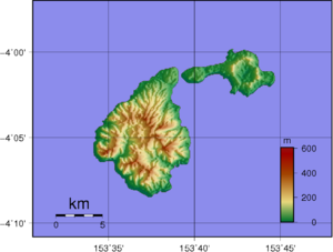
4°05′S 153°39′E / 4.08°S 153.65°E / -4.08; 153.65[1]Ambitle is a volcanic island which, together with Babase, another volcanic island, is one of the two Feni Islands in the Bismarck Archipelago. The island is located within the Papua New Guinea's New Ireland Province, to the east of the island of New Ireland.
Ambitle is a stratovolcano, reaching 450 metres (1,480 feet) above sea level. It last erupted in about 350 BCE based on radiocarbon dating. Its caldera, 3 kilometres (2 miles) wide, contains thermal areas on its western side. Venting of hydrothermal water also occurs in coral reefs to the west of this island.[1]
References
- ^ a b c d "Ambitle". Global Volcanism Program. Smithsonian Institution. Retrieved 2023-06-04.
Further reading
- Pichler, Thomas; Dix, George R. (May 1996). "Hydrothermal venting within a coral reef ecosystem, Ambitle Island, Papua New Guinea". Geology. 24 (5). Geological Society of America: 435–438. doi:10.1130/0091-7613(1996)024<0435:HVWACR>2.3.CO;2.
- v
- t
- e
Islands of Papua New Guinea
- Admiralty Islands
- Ali
- Ambitle
- Aua
- Auriroa
- Bam
- Baudisson
- Bougainville
- Bagabag
- Bagaman
- Babase
- Baluan
- Barahun
- Basilaki
- Big Ndrova
- Bipi
- Bismarck Archipelago
- Blup Blup
- Boagis
- Boang
- Bonvouloir Islands
- Brumer
- Buka
- Calvados Chain
- Carteret Islands
- Conflict Group
- D'Entrecasteaux Islands
- Daloloia Group
- Dart Reefs
- Daru
- Deboyne Islands
- Dobu
- Duchateau Islands
- Duke of York Island / Duke of York Islands
- Dyaul
- East
- Emirau
- Feni Islands
- Fergusson
- Goaribari
- Gonubalabala Island
- Goodenough
- Green Islands
- Gulowa
- Hastings
- Hemenahei
- Hermit Islands
- Kabakon
- Kaniet Islands
- Karkar
- Kadovar
- Kerawara
- Kiriwina
- Kiwai
- Kui
- Kuwanak
- Lihir Island / Lihir Group
- Lif
- Little Ndrova
- Long
- Los Negros
- Lou
- Louisiade Archipelago
- Lunn Island
- Madau
- Mailu
- Malendok
- Makada
- Manam
- Manne
- Manus
- Marshall Bennett
- Mioko
- Misima
- Motorina
- Mualim
- Mussau
- Mut Mut
- New Britain
- New Hanover
- New Guinea
- New Ireland
- Ninigo Islands
- Nissan
- Normanby
- North Solomon Islands
- Nuakata
- Nubara
- Nukumanu
- Nusam
- Pak
- Pam Islands
- Panapompom Islands
- Pana Tinani
- Panaeati
- Panarairai Island
- Panatinane
- Pana Wina Island
- Patio
- Pinipel
- Pocklington Reef
- Purdy
- Purutu
- Rambutyo
- Renard Islands
- Ritter
- Rossel (Yela)
- Sae
- Sakar
- Samarai
- Sanaroa
- Schouten Islands
- Selapiu
- Seleo
- Sideia
- Simberi
- Sirot
- St. Andrews Islands
- St Matthias Islands
- Strathord Islands
- Sudest
- Tabar Group
- Tabar
- Takuu
- Tanga Islands
- Tatau
- Tefa
- Tolokiwa
- Tong
- Trobriands
- Tsoilaunung
- Tumleo
- Ulu
- Umboi
- Unea
- Utian
- Vanatinai
- Vial
- Vitu Islands
- Wabuda
- Wagifa
- Western Islands
- Woodlark
- Wuvulu
- Yeina
- Yule
 Islands portal
| Authority control databases: Geographic |
|
|---|
 | This New Ireland Province geography article is a stub. You can help Wikipedia by expanding it. |
- v
- t
- e


