Amt Altdöbern


Amt Altdöbern is an Amt ("collective municipality") in the district of Oberspreewald-Lausitz, in Brandenburg, Germany. Its seat is in Altdöbern.
The Amt Altdöbern consists of the following municipalities:
- Altdöbern
- Bronkow
- Luckaitztal
- Neupetershain
- Neu-Seeland
Demography
-
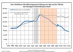 Development of Population since 1875 within the Current Boundaries (Blue Line: Population; Dotted Line: Comparison to Population Development of Brandenburg state; Grey Background: Time of Nazi rule; Red Background: Time of Communist rule)
 -
 Recent Population Development and Projections (Population Development before Census 2011 (blue line); Recent Population Development according to the Census in Germany in 2011 (blue bordered line); Official projections for 2005-2030 (yellow line); for 2017-2030 (scarlet line); for 2020-2030 (green line)


|
|
|
References
- ^ Detailed data sources are to be found in the Wikimedia Commons.Population Projection Brandenburg at Wikimedia Commons
- v
- t
- e
 Collective municipalities of Brandenburg in Germany
The Ämter are listed per district (Landkreis)
- Biesenthal-Barnim
- Britz-Chorin-Oderberg
- Joachimsthal (Schorfheide)
- Elsterland
- Kleine Elster (Niederlausitz)
- Plessa
- Schlieben
- Schradenland
- Liebenwerda (VG)
- Lindow (Mark)
- Neustadt (Dosse)
- Temnitz
51°39′02″N 14°02′04″E / 51.650694°N 14.034528°E / 51.650694; 14.034528
 | This Brandenburg location article is a stub. You can help Wikipedia by expanding it. |
- v
- t
- e


