Anjozorobe
Town in Analamanga, Madagascar
18°24′12″S 47°51′00″E / 18.40333°S 47.85000°E / -18.40333; 47.85000 Madagascar
2018
105
Anjozorobe is a large town in the Analamanga Region, Madagascar, approximately 90 kilometers north-east of the capital Antananarivo. It has a population of 24,117 inhabitants in 2018.
Anjozorobe-Angavo Reserve is one of the last high plateau forest in Madagascar. Another high plateau forest is located in the protected area of Ambohitantely.
Routes
The town is linked with Antananarivo by the National Road 3.
Rivers
The Mananara, an affluet on the Betsiboka River, flows near this municipality.
Nature reserves
The Anjozorobe-Angavo Reserve is situated approximately 11 km East of the town.
Gallery
-
 Church of Anjozorobe
 -
 College
 -
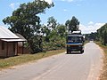 RN 3
RN 3 -
 Town hall
 -
 Post office
 -
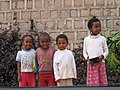 and its people


References
- ^ IMAGES AERIENNES DANS LE CADRE DE LA DEGRADATION DE L’OCCUPATION DU SOL DE LA COMMUNE URBAINE D’ANJOZOROBE
External links
- Conservation of the Anjozorobe Forest Corridor
- FANAMBY Conservation in Anjozorobe
Wikimedia Commons has media related to Anjozorobe.
- v
- t
- e
Communes in the Analamanga Region of the Republic of MadagascarCapital: Antananarivo
- Ambato
- Ambatolampy Tsimahafotsy
- Ambohidratrimo
- Ambohimanjaka
- Ambohipihaonana
- Ambohitrimanjaka
- Ampangabe
- Ampanotokana
- Anjanadoria
- Anosiala
- Antanetibe
- Antehiroka
- Antsahafilo
- Avaratsena
- Fiadanana
- Iarinarivo
- Ivato
- Mahabo
- Mahereza
- Mahitsy
- Mananjara
- Manjakavaradrano
- Merimandroso
- Talatamaty

- Alakamisy Fenoarivo
- Alatsinainy Ambazaha
- Ambalavao
- Ambatofahavalo
- Ambavahaditokana
- Ambohidrapeto
- Ambohijanaka
- Ampahitrosy
- Ampanefy
- Ampitatafika
- Andoharanofotsy
- Andranonahoatra
- Androhibe Antsahadinta
- Ankadimanga
- Ankaraobato
- Anosizato Andrefana
- Antanetikely
- Bemasoandro
- Bongatsara
- Fenoarivo
- Fiombonana
- Itaosy
- Soalandy
- Soavina
- Tanjombato
- Tsiafahy
8 districts; 137 communes
 | This Analamanga location article is a stub. You can help Wikipedia by expanding it. |
- v
- t
- e


