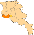
Apaga, Armenia
40°05′46″N 44°15′04″E / 40.09611°N 44.25111°E / 40.09611; 44.25111
You can help expand this article with text translated from the corresponding article in Armenian. (June 2020) Click [show] for important translation instructions.
- Machine translation, like DeepL or Google Translate, is a useful starting point for translations, but translators must revise errors as necessary and confirm that the translation is accurate, rather than simply copy-pasting machine-translated text into the English Wikipedia.
- Do not translate text that appears unreliable or low-quality. If possible, verify the text with references provided in the foreign-language article.
- You must provide copyright attribution in the edit summary accompanying your translation by providing an interlanguage link to the source of your translation. A model attribution edit summary is
Content in this edit is translated from the existing Armenian Wikipedia article at [[:hy:Ապագա (Արմավիրի մարզ)]]; see its history for attribution. - You may also add the template
{{Translated|hy|Ապագա (Արմավիրի մարզ)}}to the talk page. - For more guidance, see Wikipedia:Translation.
Place in Armavir, Armenia
Apaga Ապագա | |
|---|---|
  Apaga | |
| Coordinates: 40°05′46″N 44°15′04″E / 40.09611°N 44.25111°E / 40.09611; 44.25111 | |
| Country |  Armenia Armenia |
| Marz (Province) | Armavir |
| Area | |
| • Total | 8.27 km2 (3.19 sq mi) |
| Elevation | 820 m (2,690 ft) |
| Population (2011) | |
| • Total | 1,853 |
| • Density | 220/km2 (580/sq mi) |
| Demonym | Apagetsi |
| Time zone | UTC+4 ( ) |
| • Summer (DST) | UTC+5 ( ) |
| Area code | +374 (23) |
Apaga (Armenian: Ապագա, lit. 'future'; until 1935, Verin Turkmenlu)[1] is a town in the Armavir Province of Armenia.
See also
- Armavir Province
References
- ^ John Brady Kiesling, Raffi Kojian (2001). Rediscovering Armenia: An Archaeological/touristic Gazetteer and Map Set for the Historical Monuments of Armenia. Yerevan: Tigran Mets; p. 40
- Apaga, Armenia at GEOnet Names Server
- World Gazeteer: Armenia[dead link] – World-Gazetteer.com
- Report of the results of the 2001 Armenian Census, Statistical Committee of Armenia
- Kiesling, Brady (June 2000). Rediscovering Armenia: An Archaeological/Touristic Gazetteer and Map Set for the Historical Monuments of Armenia (PDF). Archived (PDF) from the original on 6 November 2021.
- v
- t
- e
 Armavir Province
Capital: Armavir
- Armavir
- Metsamor
- Vagharshapat

 | This article about a location in Armavir Province, Armenia is a stub. You can help Wikipedia by expanding it. |
- v
- t
- e


