Banholt
Village in Limburg, Netherlands
Banholt Tebannet | |
|---|---|
Village | |
 Farm in Banholt | |
50°47′23″N 5°48′34″E / 50.78972°N 5.80944°E / 50.78972; 5.80944 | |
| Country | Netherlands |
| Province | Limburg (Netherlands) |
| Municipality | Eijsden-Margraten |
| Area | |
| • Total | 4.55 km2 (1.76 sq mi) |
| Elevation | 173 m (568 ft) |
| Population (2021)[1] | |
| • Total | 1,015 |
| • Density | 220/km2 (580/sq mi) |
| Time zone | UTC+1 (CET) |
| • Summer (DST) | UTC+2 (CEST) |
| Postal code | 6262[1] |
| Dialing code | 043 |
| Major roads | N278 |
Banholt (Limburgish: Tebannet) is a village in the Dutch province of Limburg. It is part of the municipality of Eijsden-Margraten and lies about 10 km southeast of Maastricht.
The village was first mentioned in 1294 or 1295 as Bannoyt.[3] Banholt which developed in the Middle Ages on the plateau of Margraten. In the 18th century, it became a road village.[4]
The Catholic St Gerlachus Church is a three aisled church with wide church which was constructed between 1874 and 1876.[4] Banholt was home to 471 people in 1840.[5]
Gallery
-
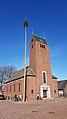 St Gerlachus Church
 -
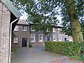 Court of a farm in Banholt
 -
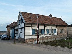
 Building in Banholt


References
- ^ a b c "Kerncijfers wijken en buurten 2021". Central Bureau of Statistics. Retrieved 24 April 2022.
- ^ "Postcodetool for 6262NA". Actueel Hoogtebestand Nederland (in Dutch). Het Waterschapshuis. Retrieved 24 April 2022.
- ^ "Banholt - (geografische naam)". Etymologiebank (in Dutch). Retrieved 24 April 2022.
- ^ a b Sabine Broekhoven, & Ronald Stenvert (2003). Banholt (in Dutch). Zwolle: Waanders. ISBN 90 400 9623 6. Retrieved 24 April 2022.
- ^ "Banholt". Plaatsengids (in Dutch). Retrieved 24 April 2022.
Wikimedia Commons has media related to Banholt.
- v
- t
- e
Populated places in the municipality of Eijsden-Margraten
- Banholt
- Bemelen
- Cadier en Keer
- Eckelrade
- Eijsden
- Gronsveld
- Margraten
- Mesch
- Mheer
- Noorbeek
- Oost-Maarland
- Rijckholt
- Scheulder [nl]
- Sint Geertruid
List of cities, towns and villages in Limburg (Netherlands)
 | This Dutch Limburg location article is a stub. You can help Wikipedia by expanding it. |
- v
- t
- e


