Berkeley Hills Tunnel
Rapid transit tunnel in California, US
37°51′05″N 122°14′17″W / 37.85139°N 122.23806°W / 37.85139; -122.23806Orinda portal:
37°52′29″N 122°11′16″W / 37.87472°N 122.18778°W / 37.87472; -122.18778
(Indian gauge)
The Berkeley Hills Tunnel is a tunnel which carries Bay Area Rapid Transit (BART) Yellow Line through the Berkeley Hills between Rockridge station and Orinda station.
Design
While the tracks run in the median of California State Route 24 on both sides of the tunnel, the Berkeley Hills Tunnel allows the tracks to take a straighter alignment offset to the north of the Caldecott Tunnel.
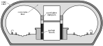
The tunnel bores through the Berkeley Hills east of Berkeley and Oakland a distance of 3.1 miles (5.0 km)[3] through a variety of rock strata, most of which are soft and porous. The earthquake-active Hayward Fault bisects the tunnel about 900 feet (270 m) inside the west portal (Oakland side). There are 2 bores, each 17.5 feet (5.3 m) in diameter,[3] spaced 50 feet (15 m) apart. Pedestrian cross-tunnels are spaced every 1,000 feet (300 m) for emergency evacuation in case of fire, etc. There is a ventilation structure at the east portal with roll-down doors that can close off the tunnel end to allow air to be sucked out or blown in.
By 2017, cumulative minor damage from fault creep had significantly reduced the tunnel's cross section, to the point where BART determined it was necessary to plan for repair and mitigation against future creep.[4] The work, which includes excavating the tunnel walls and realigning the tracks, is expected to cost $60 million.[5]
Construction
Construction of the tunnel began in early February, 1965. The bores were holed through by March, 1967, and construction completed in July, 1968.[6] The tunnel was opened for revenue service on May 21, 1973, with the Concord line.[7]
Material removed in the construction of the tunnel was used as fill for a concurrent expansion of the Port of Oakland.[8]
Incidents
On December 4, 2013, a BART train suffered mechanical braking problems and made an emergency stop in the tunnel near Rockridge station. Eleven people were treated for smoke inhalation.[9]
See also
References
- ^ "Figure 12".
- ^ "The Composite Report Bay Area Rapid Transit". Archive.org. Parsons Brinckerhoff / Tudor / Bechtel. pp. 19, 20. Retrieved 23 July 2018.
- ^ a b c Rogers & Peck. "Engineering Geology of the Bay Area Rapid Transit (BART) System, 1964-75". Index of /~mly/www.geolith.com. Geolith Engineering. Retrieved 22 June 2017.
- ^ "August Monthly Meeting: Caldecott BART Tunnel Creep Repair - SEAONC". www.seaonc.org. Archived from the original on 2017-12-01. Retrieved 2018-11-05.
- ^ "BART Board Workshop" (PDF). San Francisco Bay Area Rapid Transit Agency. February 2018. Retrieved April 28, 2019.
- ^ "Engineering Geology of the Bay Area Rapid Transit (BART) System, 1964-75", Geolith Consultants, 2000, archived from a defunct website
- ^ "BART Chronology January 1947 – March 2009" (PDF). San Francisco Bay Area Rapid Transit District. March 2009. Archived from the original (PDF) on October 13, 2013.
- ^ Berkeley Gazette, October 24, 1966, p.13
- ^ Shields, Brian (December 4, 2013). "BART Brake Smoke Causes Injuries in Caldecott Tube". KRON4. Archived from the original on March 2, 2014. Retrieved 2013-12-05.
- v
- t
- e
Bay Area Rapid Transit (BART)
| Rapid transit |
|
|---|---|
| Light rail |
|
| Automated guideway transit |
| Alameda County |
| ||||||
|---|---|---|---|---|---|---|---|
| Contra Costa County |
| ||||||
| San Francisco | |||||||
| San Mateo County |
| ||||||
| Santa Clara County |
| ||||||

- Berkeley Hills Tunnel
- Doolittle Maintenance and Storage Facility
- Market Street subway
- Oakland Wye
- Ohlone Greenway
- Transbay Tube
- Planned expansion
- Purple Line
managers
- B. R. Stokes (1963–1974)
- Larry Dahms (Acting)
- Frank Herringer
- Keith Bernard
- Frank Wilson (1989–1994)
- Richard A. White (1994–1996)
- Thomas Margro (1996–2007)
- Dorothy Dugger (2007–2011)
- Grace Crunican (2011–2019)
- Bob Powers (2019–present)
- Rolling stock
- BART Police
- Bay Area Rapid Transit District
- Clipper card
- Library-A-Go-Go
- Valley Link
- Category for related articles
Tunnels in the San Francisco Bay Area | ||||||||||||||||||
|---|---|---|---|---|---|---|---|---|---|---|---|---|---|---|---|---|---|---|
| Rail |
|  | ||||||||||||||||
| Road |
| |||||||||||||||||
| Utility | ||||||||||||||||||


