Blaison-Gohier
Part of Blaison-Saint-Sulpice in Pays de la Loire, France
Location of Blaison-Gohier

47°24′02″N 0°22′12″W / 47.4006°N 0.37°W / 47.4006; -0.37
1
(2019)[1]
49320
(avg. 35 m or 115 ft)
Blaison-Gohier (French pronunciation: [blɛzɔ̃ ɡɔje] ⓘ) is a former commune in the Maine-et-Loire department in western France. On 1 January 2016, it was merged into the new commune of Blaison-Saint-Sulpice.[2]
Population
|
|
-
 Castle of Blaison
 -
 Motte-and-bailey of Blaison, before the castle
 -
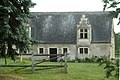 Tithe barn of Blaison


See also
References
External links
Wikimedia Commons has media related to Blaison-Gohier.
- Official site
Authority control databases | |
|---|---|
| International |
|
| National |
|
- v
- t
- e


