Camou-Cihigue
Commune in Nouvelle-Aquitaine, France
Camou-Cihigue Gamere-Zihiga | ||
|---|---|---|
Commune | ||
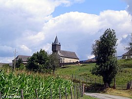 Church of Cihigue | ||
Location of Camou-Cihigue  | ||
(2020–2026) Charles Anicet Leurgorry[1] | | |
| Area 1 | 10.08 km2 (3.89 sq mi) | |
| Population (2021)[2] | 103 | |
| • Density | 10/km2 (26/sq mi) | |
| Time zone | UTC+01:00 (CET) | |
| • Summer (DST) | UTC+02:00 (CEST) | |
| INSEE/Postal code | 64162 /64470 | |
| Elevation | 208–1,009 m (682–3,310 ft) (avg. 263 m or 863 ft) | |
| 1 French Land Register data, which excludes lakes, ponds, glaciers > 1 km2 (0.386 sq mi or 247 acres) and river estuaries. | ||
Camou-Cihigue (French pronunciation: [kamu si.iɡ]; Basque: Gamere-Zihiga)[3] is a commune in the Pyrénées-Atlantiques department in south-western France.[4]
It is located in the former province of Soule.[3]
Geography
Neughboring communes:
- Ossas-Suhare, in the north
- Aussurucq, in the north-west
- Alos-Sibas-Abense, in the east
- Alçay-Alçabéhéty-Sunharette, in the south
History
The commune of Camou-Cihigue was formed in 1836, from the merger of the former communes of Camou and Cihigue.
See also
References
- ^ "Répertoire national des élus: les maires" (in French). data.gouv.fr, Plateforme ouverte des données publiques françaises. 13 September 2022.
- ^ "Populations légales 2021". The National Institute of Statistics and Economic Studies. 28 December 2023.
- ^ a b GAMERE-ZIHIGA, Auñamendi Eusko Entziklopedia (in Spanish)
- ^ INSEE commune file
Wikimedia Commons has media related to Camou-Cihigue.
- v
- t
- e
- Ainharbe
- Aloze-Ziboze-Onizegaine
- Altzai-Altzabeheti-Zunharreta
- Altzürukü
- Arrokiaga
- Arüe-Ithorrotze-Olhaibi
- Atharratze-Sorholüze
- Barkoxe
- Berrogaine-Lahüntze
- Bildoze-Onizepea
- Domintxaine-Berroeta
- Eskiula
- Espeize-Ündüreine
- Etxarri
- Etxebarre
- Gamere-Zihiga
- Garindaine
- Gotaine-Irabarne
- Hauze
- Idauze-Mendi
- Iruri
- Jestaze
- Lakarri-Arhane-Sarrikotagaine
- Larraine
- Lexantzü-Zünharre
- Ligi-Atherei
- Liginaga-Astüe
- Lohitzüne-Oihergi
- Maule-Lextarre
- Mendikota
- Mitikile-Larrori-Mendibile
- Montori
- Muskildi
- Ospitalepea
- Ozaraine-Erribareita
- Ozaze-Zühara
- Pagola
- Sarrikotape
- Sohüta
- Urdatx-Santa-Grazi
- Urdiñarbe
- Ürrustoi-Larrebille
- Zalgize-Doneztebe


| Authority control databases: National |
|
|---|
 | This Pyrénées-Atlantiques geographical article is a stub. You can help Wikipedia by expanding it. |
- v
- t
- e


