Cazeneuve, Gers
Commune in Occitania, France
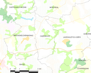
Location of Cazeneuve

(2020–2026) Martine Laborde[1]
1
(2021)[2]
32100 /32800
(avg. 250 m or 820 ft)
Cazeneuve (French pronunciation: [kaznœv]; Occitan: Casanava) is a commune in the Gers department in southwestern France.
Since 2015, the commune is a part of the Canton of Armagnac-Ténarèze.
In the neighbourhood are numerous old castles, little medieval walled villages, small cities built around castles and "sacred" places, because the Via Podiensis and the Way of St. James of Compostela are going through the Montréal and left their traces.
Geography
Population
| Year | Pop. | ±% |
|---|---|---|
| 1962 | 220 | — |
| 1968 | 205 | −6.8% |
| 1975 | 178 | −13.2% |
| 1982 | 138 | −22.5% |
| 1990 | 139 | +0.7% |
| 1999 | 127 | −8.6% |
| 2008 | 135 | +6.3% |
See also
References
- ^ "Répertoire national des élus: les maires". data.gouv.fr, Plateforme ouverte des données publiques françaises (in French). 2 December 2020.
- ^ "Populations légales 2021" (in French). The National Institute of Statistics and Economic Studies. 28 December 2023.
Wikimedia Commons has media related to Cazeneuve.
- v
- t
- e
Communes of the Gers department 

- Aignan
- Ansan
- Antras
- Arblade-le-Bas
- Arblade-le-Haut
- Ardizas
- Armentieux
- Armous-et-Cau
- Arrouède
- Aubiet
- Auchpref
- Augnax
- Aujan-Mournède
- Auradé
- Aurensan
- Aurimont
- Aussos
- Auterive
- Aux-Aussat
- Avensac
- Avéron-Bergelle
- Avezan
- Ayguetinte
- Ayzieu
- Bajonnette
- Barcelonne-du-Gers
- Barcugnan
- Barran
- Bars
- Bascous
- Bassoues
- Bazian
- Bazugues
- Beaucaire
- Beaumarchés
- Beaumont
- Beaupuy
- Beccas
- Bédéchan
- Bellegarde
- Belloc-Saint-Clamens
- Belmont
- Béraut
- Berdoues
- Bernède
- Berrac
- Betcave-Aguin
- Bétous
- Betplan
- Bézéril
- Bezolles
- Bézues-Bajon
- Biran
- Bivès
- Blanquefort
- Blaziert
- Blousson-Sérian
- Bonas
- Boucagnères
- Boulaur
- Bourrouillan
- Bouzon-Gellenave
- Bretagne-d'Armagnac
- Le Brouilh-Monbert
- Brugnens
- Cabas-Loumassès
- Cadeilhan
- Cadeillan
- Cahuzac-sur-Adour
- Caillavet
- Callian
- Campagne-d'Armagnac
- Cassaigne
- Castelnau-Barbarens
- Castelnau-d'Anglès
- Castelnau-d'Arbieu
- Castelnau-d'Auzan-Labarrère
- Castelnau-sur-l'Auvignon
- Castelnavet
- Castéra-Lectourois
- Castéra-Verduzan
- Castéron
- Castet-Arrouy
- Castex
- Castex-d'Armagnac
- Castillon-Debats
- Castillon-Massas
- Castillon-Savès
- Castin
- Catonvielle
- Caumont
- Caupenne-d'Armagnac
- Caussens
- Cazaubon
- Cazaux-d'Anglès
- Cazaux-Savès
- Cazaux-Villecomtal
- Cazeneuve
- Céran
- Cézan
- Chélan
- Clermont-Pouyguillès
- Clermont-Savès
- Cologne
- Condomsubpr
- Corneillan
- Couloumé-Mondebat
- Courrensan
- Courties
- Crastes
- Cravencères
- Cuélas
- Dému
- Duffort
- Duran
- Durban
- Eauze
- Encausse
- Endoufielle
- Esclassan-Labastide
- Escornebœuf
- Espaon
- Espas
- Estampes
- Estang
- Estipouy
- Estramiac
- Faget-Abbatial
- Flamarens
- Fleurance
- Fourcès
- Frégouville
- Fustérouau
- Galiax
- Garravet
- Gaudonville
- Gaujac
- Gaujan
- Gavarret-sur-Aulouste
- Gazaupouy
- Gazax-et-Baccarisse
- Gée-Rivière
- Gimbrède
- Gimont
- Giscaro
- Gondrin
- Goutz
- Goux
- Haget
- Haulies
- Homps
- Le Houga
- Idrac-Respaillès
- L'Isle-Arné
- L'Isle-Bouzon
- L'Isle-de-Noé
- L'Isle-Jourdain
- Izotges
- Jegun
- Jû-Belloc
- Juillac
- Juilles
- Justian
- Laas
- Labarthe
- Labarthète
- Labastide-Savès
- Labéjan
- Labrihe
- Ladevèze-Rivière
- Ladevèze-Ville
- Lagarde
- Lagarde-Hachan
- Lagardère
- Lagraulet-du-Gers
- Laguian-Mazous
- Lahas
- Lahitte
- Lalanne
- Lalanne-Arqué
- Lamaguère
- Lamazère
- Lamothe-Goas
- Lannemaignan
- Lannepax
- Lanne-Soubiran
- Lannux
- Larée
- Larressingle
- Larroque-Engalin
- Larroque-Saint-Sernin
- Larroque-sur-l'Osse
- Lartigue
- Lasséran
- Lasserrade
- Lasseube-Propre
- Laujuzan
- Lauraët
- Lavardens
- Laveraët
- Laymont
- Leboulin
- Lectoure
- Lelin-Lapujolle
- Lias
- Lias-d'Armagnac
- Ligardes
- Lombez
- Loubédat
- Loubersan
- Lourties-Monbrun
- Louslitges
- Loussous-Débat
- Lupiac
- Luppé-Violles
- Lussan
- Magnan
- Magnas
- Maignaut-Tauzia
- Malabat
- Manas-Bastanous
- Manciet
- Manent-Montané
- Mansempuy
- Mansencôme
- Marambat
- Maravat
- Marciac
- Marestaing
- Margouët-Meymes
- Marguestau
- Marsan
- Marseillan
- Marsolan
- Mascaras
- Mas-d'Auvignon
- Masseube
- Mauléon-d'Armagnac
- Maulichères
- Maumusson-Laguian
- Maupas
- Maurens
- Mauroux
- Mauvezin
- Meilhan
- Mérens
- Miélan
- Miradoux
- Miramont-d'Astarac
- Miramont-Latour
- Mirandesubpr
- Mirannes
- Mirepoix
- Monbardon
- Monblanc
- Monbrun
- Moncassin
- Monclar
- Monclar-sur-Losse
- Moncorneil-Grazan
- Monferran-Plavès
- Monferran-Savès
- Monfort
- Mongausy
- Monguilhem
- Monlaur-Bernet
- Monlezun
- Monlezun-d'Armagnac
- Monpardiac
- Montadet
- Montamat
- Montaut
- Montaut-les-Créneaux
- Mont-d'Astarac
- Mont-de-Marrast
- Montégut
- Montégut-Arros
- Montégut-Savès
- Montesquiou
- Montestruc-sur-Gers
- Monties
- Montiron
- Montpézat
- Montréal
- Mormès
- Mouchan
- Mouchès
- Mourède
- Nizas
- Nogaro
- Noilhan
- Nougaroulet
- Noulens
- Orbessan
- Ordan-Larroque
- Ornézan
- Pallanne
- Panassac
- Panjas
- Pauilhac
- Pavie
- Pébées
- Pellefigue
- Perchède
- Pergain-Taillac
- Pessan
- Pessoulens
- Peyrecave
- Peyrusse-Grande
- Peyrusse-Massas
- Peyrusse-Vieille
- Pis
- Plaisance
- Plieux
- Polastron
- Pompiac
- Ponsampère
- Ponsan-Soubiran
- Pouydraguin
- Pouylebon
- Pouy-Loubrin
- Pouy-Roquelaure
- Préchac
- Préchac-sur-Adour
- Preignan
- Préneron
- Projan
- Pujaudran
- Puycasquier
- Puylausic
- Puységur
- Ramouzens
- Razengues
- Réans
- Réjaumont
- Ricourt
- Riguepeu
- Riscle
- La Romieu
- Roquebrune
- Roquefort
- Roquelaure
- Roquelaure-Saint-Aubin
- Roquepine
- Roques
- Rozès
- Sabaillan
- Sabazan
- Sadeillan
- Saint-André
- Saint-Antoine
- Saint-Antonin
- Saint-Arailles
- Saint-Arroman
- Saint-Aunix-Lengros
- Saint-Avit-Frandat
- Saint-Blancard
- Saint-Brès
- Saint-Caprais
- Saint-Christaud
- Saint-Clar
- Saint-Créac
- Saint-Cricq
- Sainte-Anne
- Sainte-Aurence-Cazaux
- Sainte-Christie
- Sainte-Christie-d'Armagnac
- Sainte-Dode
- Sainte-Gemme
- Saint-Élix-d'Astarac
- Saint-Élix-Theux
- Sainte-Marie
- Sainte-Mère
- Sainte-Radegonde
- Saint-Georges
- Saint-Germé
- Saint-Germier
- Saint-Griède
- Saint-Jean-le-Comtal
- Saint-Jean-Poutge
- Saint-Justin
- Saint-Lary
- Saint-Léonard
- Saint-Lizier-du-Planté
- Saint-Loube
- Saint-Martin
- Saint-Martin-d'Armagnac
- Saint-Martin-de-Goyne
- Saint-Martin-Gimois
- Saint-Maur
- Saint-Médard
- Saint-Mézard
- Saint-Michel
- Saint-Mont
- Saint-Orens
- Saint-Orens-Pouy-Petit
- Saint-Ost
- Saint-Paul-de-Baïse
- Saint-Pierre-d'Aubézies
- Saint-Puy
- Saint-Sauvy
- Saint-Soulan
- Salles-d'Armagnac
- Samaran
- Samatan
- Sansan
- Saramon
- Sarcos
- Sarragachies
- Sarraguzan
- Sarrant
- La Sauvetat
- Sauveterre
- Sauviac
- Sauvimont
- Savignac-Mona
- Scieurac-et-Flourès
- Séailles
- Ségos
- Ségoufielle
- Seissan
- Sembouès
- Sémézies-Cachan
- Sempesserre
- Sère
- Sérempuy
- Seysses-Savès
- Simorre
- Sion
- Sirac
- Solomiac
- Sorbets
- Tachoires
- Tarsac
- Tasque
- Taybosc
- Termes-d'Armagnac
- Terraube
- Thoux
- Tieste-Uragnoux
- Tillac
- Tirent-Pontéjac
- Touget
- Toujouse
- Tourdun
- Tournan
- Tournecoupe
- Tourrenquets
- Traversères
- Troncens
- Tudelle
- Urdens
- Urgosse
- Valence-sur-Baïse
- Vergoignan
- Verlus
- Vic-Fezensac
- Viella
- Villecomtal-sur-Arros
- Villefranche-d'Astarac
- Viozan
- pref: prefecture
- subpr: subprefecture
Authority control databases | |
|---|---|
| International |
|
| National |
|
 | This Gers geographical article is a stub. You can help Wikipedia by expanding it. |
- v
- t
- e


