Coalbrook
Village in Munster, Ireland
Coalbrook Glaise an Ghuail | |
|---|---|
Village | |
 Main Street | |
| 52°36′41″N 7°34′48″W / 52.611435°N 7.580108°W / 52.611435; -7.580108 | |
| Country | Ireland |
| Province | Munster |
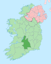
| County | County Tipperary |
| Time zone | UTC+0 (WET) |
| • Summer (DST) | UTC-1 (IST (WEST)) |
Coalbrook (Irish: Glaise an Ghuail) is a village in the Slieveardagh Hills in County Tipperary.[1] It is just off the R690 regional road and is equidistant from Kilkenny, Cashel and Thurles, about 25 km (16 mi) from all three.
Lisnamrock National School educates the children of Coalbrook and the surrounding townlands.[2]
Gallery
-
 Coalbrook
 -
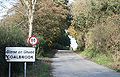
 Looking east; the R690 at the bottom of the hill


See also
References
External links
- Lisnamrock National School
- Coalbrook House - Buildings of Ireland
- v
- t
- e
Places in County Tipperary
- Ahenny
- Ardfinnan
- Ardmayle
- Ballingarry
- Ballycommon
- Ballyclerahan
- Ballylooby
- Ballyporeen
- Ballysheehan
- Bansha
- Birdhill
- Borrisoleigh
- Cappawhite
- Carrickbeg
- Castleiney
- Clogheen
- Clonmore
- Clonoulty
- Coalbrook
- Cullen
- Dolla
- Donohill
- Drom
- Dromineer
- Dualla
- Dundrum
- Emly
- Fethard
- Golden
- Gortnahoe
- Grange
- Grangemockler
- Hollyford
- Holycross
- Horse and Jockey
- Killea
- Kilsheelan
- Lattin
- Lisronagh
- Littleton
- Lorrha
- Loughmore
- Marlfield
- Milestone
- Moycarkey
- Mullinahone
- New Birmingham
- New Inn
- Newcastle
- Newport
- Ninemilehouse
- Portroe
- Puckane
- Rathcabbin
- Rearcross
- Rosegreen
- Rossmore
- Silvermines
- Skeheenarinky
- Terryglass
- Toomevara
- Two-Mile Borris
- Upperchurch
- Clanwilliam
- Eliogarty
- Iffa and Offa East
- Iffa and Offa West
- Ikerrin
- Kilnamanagh Lower
- Kilnamanagh Upper
- Middle Third
- Ormond Lower
- Ormond Upper
- Owney and Arra
- Slievardagh
- List of townlands of County Tipperary
- Category:Mountains and hills of County Tipperary
- Category:Rivers of County Tipperary
- Category:Geography of County Tipperary


