Coldharbour, Havering
Human settlement in England
- London
- Dagenham and Rainham
- Havering and Redbridge
Coldharbour is an area of the London Borough of Havering by the River Thames and southwest of the Rainham Marshes Nature Reserve. It is the location of Coldharbour Point, where there has been a lighthouse since 1885. This point is adjacent to the town of Erith in Bexley, across the Thames. The nearest accessible settlement on land is the town of Rainham, which is connected by Coldharbour Lane; the village of Wennington is also nearby but not accessible by road (both are separated by the A13 and marshlands). The area around the point is mainly industrial land known as the Freightmaster Estate depot. The London Loop passes through Coldharbour on its way east to Purfleet in Thurrock.
History
Coldharbour was an estate primarily in the ancient parish of Wennington. It included Little Coldharbour (also partly in Rainham), Coldharbour Point and Great Coldharbour. It was originally a marsh island.[1]
A ferry (known as the 'short ferry' in contrast to the 'long ferry' to London) operating from Coldharbour Point to Erith (then in Kent) on the southern bank of the Thames existed from the Middle Ages until the 19th century. Plaques entitled 'Pilgrim Ferry' commemorate this in Coldharbour and Erith.
Gallery
-
 Coldharbour Point
 -
 Checkpoint on Coldharbour Lane, leading to the depot
 -
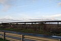 A pipeline bridge on the Rainham Marshes across the Common Watercourse
 -
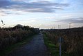 Cycleway 13, next to Coldharbour Lane
 -
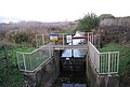 Sluice on a drainage ditch, Coldharbour Lane
 -
 The Freighmaster Estate depot - facilities include an extensive complex of warehouses, ample parking for trucks and a helipad
 -
 Cleanaways waste transfer depot, Erith can be seen in the background


References
- ^ "Wennington | British History Online".
- v
- t
- e
- Ardleigh Green
- Beam Park
- Chase Cross
- Coldharbour
- Collier Row
- Cranham
- Elm Park
- Emerson Park
- Frog Island
- Gallows Corner
- Gidea Park
- Hacton
- Harold Hill
- Harold Park
- Harold Wood
- Havering-atte-Bower
- Heath Park
- Hornchurch
- Hornchurch Marshes
- Noak Hill
- North Ockendon
- Rainham
- Rise Park
- Romford
- Rush Green
- South Hornchurch
- Upminster
- Upminster Bridge
- Wennington


- The Brewery
- The Liberty
- The Mercury
- Romford Market
- Bedfords Park
- Cranham Brickfields
- Cranham Marsh
- Dagnam Park
- Hainault Forest
- Harrow Lodge Park
- Havering Country Park
- Haynes Park
- Hornchurch Country Park
- Hylands Park
- Ingrebourne Marshes
- Ingrebourne Valley
- Lodge Farm Park
- Pages Wood
- Pyrgo Park
- Rainham Marshes Nature Reserve
- Raphael Park
- St Andrew's Park
- Tylers Common
- Weald Brook
- Wildspace Conservation Park
- Dagenham and Rainham (part)
- Hornchurch and Upminster
- Romford


 Category
 Commons

 | This London location article is a stub. You can help Wikipedia by expanding it. |
- v
- t
- e


