Dambel
Comune in Trentino-Alto Adige/Südtirol, Italy
Location of Dambel

46°24′N 11°6′E / 46.400°N 11.100°E / 46.400; 11.100
(Dec. 2004)[2]
38010
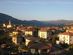
Dambel (Nones: Dambel; Latin: Ambulum) is a comune (municipality) in Trentino in the northern Italian region Trentino-Alto Adige/Südtirol, located about 35 kilometres (22 mi) north of the city of Trento.
Dambel is located in the Val di Non at an elevation of 750 metres (2,460 ft). It is on the provincial highway between Sanzeno to the south and Sarnonico to the north. The town's name derives from the Latin word ambulum because it was at an historical crossroads on the commercial road between Lombardy and Germany, which crossed through Dambel and over the Novella River at the Pozzena bridge. Today the economy of Dambel is concentrated on the production of apples.
Geography
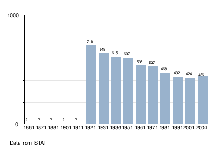
As of 31 December 2004, it had a population of 436 and an area of 5.1 square kilometres (2.0 sq mi).[3]
Dambel borders the following municipalities: Brez, Sarnonico, Cloz, Romallo, Romeno and Sanzeno.
Demographic evolution
References
- ^ "Superficie di Comuni Province e Regioni italiane al 9 ottobre 2011". Italian National Institute of Statistics. Retrieved 16 March 2019.
- ^ "Popolazione Residente al 1° Gennaio 2018". Italian National Institute of Statistics. Retrieved 16 March 2019.
- ^ All demographics and other statistics: Italian statistical institute Istat.
External links
- (in Italian) Homepage of the city
- v
- t
- e
- Ala
- Albiano
- Aldeno
- Altavalle
- Altopiano della Vigolana
- Amblar-Don
- Andalo
- Arco
- Avio
- Baselga di Pinè
- Bedollo
- Besenello
- Bieno
- Bleggio Superiore
- Bocenago
- Bondone
- Borgo Chiese
- Borgo d'Anaunia
- Borgo Lares
- Borgo Valsugana
- Brentonico
- Bresimo
- Caderzone Terme
- Calceranica al Lago
- Caldes
- Caldonazzo
- Calliano
- Campitello di Fassa
- Campodenno
- Canal San Bovo
- Canazei
- Capriana
- Carisolo
- Carzano
- Castel Condino
- Castel Ivano
- Castello Tesino
- Castello-Molina di Fiemme
- Castelnuovo
- Cavalese
- Cavareno
- Cavedago
- Cavedine
- Cavizzana
- Cembra Lisignago
- Cimone
- Cinte Tesino
- Cis
- Civezzano
- Cles
- Comano Terme
- Commezzadura
- Contà
- Croviana
- Dambel
- Denno
- Dimaro Folgarida
- Drena
- Dro
- Fai della Paganella
- Fiavé
- Fierozzo
- Folgaria
- Fornace
- Frassilongo
- Garniga Terme
- Giovo
- Giustino
- Grigno
- Imer
- Isera
- Lavarone
- Lavis
- Ledro
- Levico Terme
- Livo
- Lona-Lases
- Luserna
- Madruzzo
- Malè
- Massimeno
- Mazzin
- Mezzana
- Mezzano
- Mezzocorona
- Mezzolombardo
- Moena
- Molveno
- Mori
- Nago-Torbole
- Nogaredo
- Nomi
- Novaledo
- Novella
- Ospedaletto
- Ossana
- Palù del Fersina
- Panchià
- Peio
- Pellizzano
- Pelugo
- Pergine Valsugana
- Pieve Tesino
- Pieve di Bono-Prezzo
- Pinzolo
- Pomarolo
- Porte di Rendena
- Predaia
- Predazzo
- Primiero San Martino di Castrozza
- Rabbi
- Riva del Garda
- Romeno
- Roncegno Terme
- Ronchi Valsugana
- Ronzo-Chienis
- Ronzone
- Rovereto
- Roveré della Luna
- Ruffrè-Mendola
- Rumo
- Sagron Mis
- Samone
- San Giovanni di Fassa
- San Lorenzo Dorsino
- San Michele all'Adige
- Sant'Orsola Terme
- Sanzeno
- Sarnonico
- Scurelle
- Segonzano
- Sella Giudicarie
- Sfruz
- Soraga di Fassa
- Sover
- Spiazzo
- Spormaggiore
- Sporminore
- Stenico
- Storo
- Strembo
- Telve
- Telve di Sopra
- Tenna
- Tenno
- Terragnolo
- Terre d'Adige
- Terzolas
- Tesero
- Tione di Trento
- Ton
- Torcegno
- Trambileno
- Trento
- Tre Ville
- Valdaone
- Valfloriana
- Vallarsa
- Vallelaghi
- Vermiglio
- Vignola-Falesina
- Villa Lagarina
- Ville d'Anaunia
- Ville di Fiemme
- Volano
- Ziano di Fiemme

 | This Trentino-Alto Adige/Südtirol location article is a stub. You can help Wikipedia by expanding it. |
- v
- t
- e


