Gersloot
Village in Friesland, Netherlands
Gersloot Gersleat | |
|---|---|
Village | |
 Bell tower | |
 Coat of arms | |
 Location in Heerenveen municipality | |
53°0′23″N 5°57′51″E / 53.00639°N 5.96417°E / 53.00639; 5.96417 | |
| Country |  Netherlands Netherlands |
| Province |  Friesland Friesland |
| Municipality |  Heerenveen Heerenveen |
| Area | |
| • Total | 1.48 km2 (0.57 sq mi) |
| Elevation | −0.8 m (−2.6 ft) |
| Population (2021)[1] | |
| • Total | 105 |
| • Density | 71/km2 (180/sq mi) |
| Postal code | 8457[1] |
| Dialing code | 0513 |
Gersloot (West Frisian: Gersleat) is a village in Heerenveen in the province of Friesland, the Netherlands.
The village was first mentioned in 1281 as Gerslach and means tapered ditch.[3] It used to have a church, but it was demolished in 1735, and only the bell tower remains. In 1840, it was home to 146 people.[4] Before 1934, Gersloot was part of the Aengwirden municipality.[4]
Gallery
-
 Pumping station Tripgemaal
 -
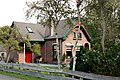 House in Gersloot


References
- ^ a b c "Kerncijfers wijken en buurten 2021". Central Bureau of Statistics. Retrieved 30 March 2022.
- ^ "Postcodetool for 8457CB". Actueel Hoogtebestand Nederland (in Dutch). Het Waterschapshuis. Retrieved 30 March 2022.
- ^ "Gersloot - (geografische naam)". Etymologiebank (in Dutch). Retrieved 30 March 2022.
- ^ a b "Gersloot". Plaatsengids (in Dutch). Retrieved 30 March 2022.
External links
![]() Media related to Gersloot at Wikimedia Commons
Media related to Gersloot at Wikimedia Commons
- v
- t
- e
Populated places in the municipality of Heerenveen
- Heerenveen
- Former municipalities:
- Aengwirden
- Schoterland
- Akkrum
- Aldeboarn
- Bontebok
- Gersloot
- Gersloot-Polder [nl]
- Haskerdijken
- Hoornsterzwaag
- Jubbega
- Katlijk
- De Knipe
- Luinjeberd
- Mildam
- Nes
- Nieuwebrug
- Nieuwehorne
- Nieuweschoot
- Oranjewoud
- Oudehorne
- Oudeschoot
- Terband
- Tjalleberd
- Former villages:
- Nijehaske
 | This Friesland location article is a stub. You can help Wikipedia by expanding it. |
- v
- t
- e


