Gleidorf
Stadtteil of Schmallenberg in North Rhine-Westphalia, Germany

Coat of arms
Location of Gleidorf

51°9′52″N 8°18′46″E / 51.16444°N 8.31278°E / 51.16444; 8.31278
(2021-12-31)
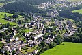
Gleidorf is a locality in the municipality Schmallenberg in the High Sauerland District in North Rhine-Westphalia, Germany.
The village has 1371 inhabitants[1] and lies in the east of the municipality of Schmallenberg at a height of around 393 m. The river Lenne flows through the village. In the village centre the B 236 federal road meets the B 511. Gleidorf borders on the villages of Schmallenberg, Bad Fredeburg, Grafschaft, Holthausen and Winkhausen.
The first written document mentioning Gleidorf dates from 1072 in a charter from Grafschaft Abbey of bishop Anno of Cologne. The village used to belong to the municipality of Grafschaft in Amt Schmallenberg until the end of 1974.[2]
Gallery
-
 Sacred Heart church
 -
 Village center


External links
- Gleidorf (in German)
References
- ^ Schmallenberg.de: Inhabitants Archived 2023-03-23 at the Wayback Machine (in German)
- ^ Statistisches Bundesamt (Hrsg.): Historisches Gemeindeverzeichnis für die Bundesrepublik Deutschland. Namens-, Grenz- und Schlüsselnummernänderungen bei Gemeinden, Kreisen und Regierungsbezirken vom 27.5.1970 bis 31.12.1982. W. Kohlhammer, Stuttgart/Mainz 1983, ISBN 3-17-003263-1, S. 335 f.
Authority control databases | |
|---|---|
| International |
|
| National |
|


