Glymur
Waterfall in Iceland
64°23′45″N 21°14′28″W / 64.39583°N 21.24111°W / 64.39583; -21.24111
Glymur (Icelandic pronunciation: [ˈklɪːmʏr̥] ⓘ) is a waterfall in Hvalfjarðarsveit, Vesturland, Iceland. It is the second-tallest in the country with a cascade of 198 metres (650 ft). Glymur was long regarded as the tallest until being surpassed by Morsárfoss, a newly measured waterfall near Morsárjökull in 2011.[1]
It is situated at the rear end of the Hvalfjörður. Since the opening of the Hvalfjörður Tunnel under this fjord, visitor numbers have dropped.[citation needed]
The river Botnsá [ˈpɔsːˌauː] runs from the Hvalvatn lake and after a short distance the water falls down alongside the Hvalfell mountain into a steep canyon. The waterfall can be accessed from a parking area at the end of the road. Hikers can view the waterfall from marked paths on the east side of the river Botnsá.
Gallery
-
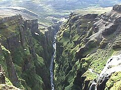 Downstream view of the canyon
 -
 Legend of Rauðhöfði


The second picture is an engraving showing people trying to escape from a monster whale. It is an illustration of the Icelandic legend of Redhead (Rauðhöfði [ˈrœyðˌhœvðɪ]) which is said to be the cause of the formation of Glymur.
See also
- List of waterfalls
- Waterfalls of Iceland
References
- ^ Guðmundsson, Janus Arn (15 June 2011). "Flyst hæsti foss landsins búferlum?" (in Icelandic). Morgunblaðið. Retrieved 1 August 2015.
External links
Wikimedia Commons has media related to Glymur.
- Information
- v
- t
- e
Waterfalls of Iceland
- Álafoss
- Aldeyjarfoss
- Barnafossar
- Dettifoss
- Dynjandi
- Fagrifoss
- Faxi
- Gjáin
- Gljúfrafoss
- Gluggafoss
- Glymur
- Goðafoss
- Granni
- Gullfoss
- Hafragilsfoss
- Háifoss
- Hengifoss
- Hjálparfoss
- Hraunfossar
- Litlanesfoss
- Morsárfoss
- Ófærufoss
- Öxarárfoss
- Selfoss
- Seljalandsfoss
- Skógafoss
- Svartifoss
- Systrafoss
- Þjófafoss
- Urriðafoss

Authority control databases | |
|---|---|
| International |
|
| Geographic |
|
 | This Iceland location article is a stub. You can help Wikipedia by expanding it. |
- v
- t
- e


