Grade I and II* listed buildings in the London Borough of Newham
Map all coordinates using OpenStreetMap
Download coordinates as:
- KML
- GPX (all coordinates)
- GPX (primary coordinates)
- GPX (secondary coordinates)
There are over 9,000 Grade I listed buildings and 20,000 Grade II* listed buildings in England. This page is a list of these buildings in the London Borough of Newham.
Grade I
| Name | Location | Type | Completed [note 1] | Date designated | Grid ref.[note 2] Geo-coordinates | Entry number [note 3] | Image |
|---|---|---|---|---|---|---|---|
| Church of All Saints | Newham | Church | 12th century | 25 October 1984 | TQ3941283862 51°32′11″N 0°00′31″E / 51.536453°N 0.008694°E / 51.536453; 0.008694 (Church of All Saints) | 1358002 |  More images |
| Church of St Mary Magdalene | Newham | Church | 12th century | 21 October 1982 | TQ4292982378 51°31′20″N 0°03′32″E / 51.52224°N 0.058767°E / 51.52224; 0.058767 (Church of St Mary Magdalene) | 1080961 |  More images |
| Church of St Mary the Virgin | Little Ilford, Manor Park, Newham | Church | 12th century | 17 November 1980 | TQ4289885292 51°32′54″N 0°03′34″E / 51.548432°N 0.059502°E / 51.548432; 0.059502 (Church of St Mary the Virgin) | 1190948 |  More images |
| Tide Mill (known as the House Mill) | Bromley by Bow, Newham | Mill | 1776 | 30 March 1955 | TQ3828582826 51°31′39″N 0°00′29″W / 51.527421°N 0.007951°W / 51.527421; -0.007951 (Tide Mill (known as the House Mill)) | 1080970 |  More images |
Grade II*
| Name | Location | Type | Completed [note 1] | Date designated | Grid ref.[note 2] Geo-coordinates | Entry number [note 3] | Image |
|---|---|---|---|---|---|---|---|
| Abbey Mills Pumping Stations | Newham | Sewage Pumping Station | 1868 | 6 November 1974 | TQ3871583222 51°31′51″N 0°00′06″W / 51.530874°N 0.001601°W / 51.530874; -0.001601 (Abbey Mills Pumping Stations) | 1190476 |  More images |
| Former St Mark's Church (Brick Lane Music Hall) | Newham | Parish Church | Built 1860–62 | 17 December 1971 | TQ4188980173 51°30′10″N 0°02′34″E / 51.502688°N 0.0429°E / 51.502688; 0.0429 (Former St Mark's Church (Brick Lane Music Hall)) | 1080963 |  More images |
| Gallions Hotel | Beckton, Newham | Hotel | 1881–1883 | 27 August 1998 | TQ4397280689 51°30′24″N 0°04′23″E / 51.506798°N 0.073101°E / 51.506798; 0.073101 (Gallions Hotel) | 1376224 | 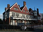 More images |
| Newham Council Offices | Newham | Town Hall | 1901-3 | 31 January 1973 | TQ4268083544 51°31′58″N 0°03′20″E / 51.53278°N 0.055652°E / 51.53278; 0.055652 (Newham Council Offices) | 1190712 |  More images |
| The Theatre Royal | Newham | Theatre | 1884 | 28 June 1972 | TQ3885584527 51°32′33″N 0°00′03″E / 51.542566°N 0.00093°E / 51.542566; 0.00093 (The Theatre Royal) | 1293425 |  More images |
| University House, University of East London (West Ham Precinct) | Newham | Column | 1895–98 | 25 October 1984 | TQ3946184629 51°32′36″N 0°00′35″E / 51.543333°N 0.009704°E / 51.543333; 0.009704 (University House, University of East London (West Ham Precinct)) | 1080964 |  |
Notes
- ^ a b The date given is the date used by Historic England as significant for the initial building or that of an important part in the structure's description.
- ^ a b Sometimes known as OSGB36, the grid reference is based on the British national grid reference system used by the Ordnance Survey.
- ^ a b The "List Entry Number" is a unique number assigned to each listed building and scheduled monument by Historic England.
External links
 Media related to Grade I listed buildings in the London Borough of Newham at Wikimedia Commons
- Media related to Grade II* listed buildings in the London Borough of Newham at Wikimedia Commons
- v
- t
- e
- Beckton (including Cyprus)
- Canning Town (including Limmo Peninsula)
- Custom House
- East Ham (including Plashet and Wall End)
- Forest Gate
- Manor Park (including Little Ilford)
- Plaistow (including Greengate)
- Silvertown
- Stratford (including East Village, Maryland, Mill Meads)
- Temple Mills
- Upton Park
- West Ham
- North Woolwich


and markets
open spaces
- Abbey Gardens
- Beckton District Park
- Bow Creek Ecology Park
- Central Park
- Epping Forest
- Forest Lane Park
- King George V Park
- Little Ilford Park
- Memorial Recreation Ground
- New Beckton Park
- Plashet Park
- Star Park
- Thames Barrier Park
- Three Mills Green
- Wanstead Flats
- West Ham Park
- East Ham
- West Ham
DLR stations
 Abbey Road
- Beckton
- Beckton Park
-
 Canning Town
 - Custom House for ExCel
- Cyprus
- East Ham
 Forest Gate
- Gallions Reach
- King George V
- London City Airport
- Manor Park
- Maryland
- Plaistow
- Pontoon Dock
- Prince Regent
- Pudding Mill Lane
- Royal Albert
- Royal Victoria
- Star Lane
-

 Stratford
 - Stratford High Street
- Stratford International
- Upton Park
- Wanstead Park
- West Ham
- West Silvertown
- Woodgrange Park


- Council
- Grade I and II* listed buildings
- People
- Public art
- Schools
 Category
- Commons

Portals:
 London
 Architecture


