Grade I and II* listed buildings in the London Borough of Sutton
Map all coordinates using OpenStreetMap
Download coordinates as:
- KML
- GPX (all coordinates)
- GPX (primary coordinates)
- GPX (secondary coordinates)
There are over 9,000 Grade I listed buildings and 20,000 Grade II* listed buildings in England. This page is a list of these buildings in the London Borough of Sutton.
Grade I
| Name | Location | Type | Completed [note 1] | Date designated | Grid ref.[note 2] Geo-coordinates | Entry number [note 3] | Image |
|---|---|---|---|---|---|---|---|
| Beddington Place (Great Hall only) | Beddington, Sutton | Bell Tower | 1850 | 21 January 1954 | TQ2962165302 51°22′19″N 0°08′21″W / 51.37199°N 0.139187°W / 51.37199; -0.139187 (Beddington Place (Great Hall only)) | 1065672 | 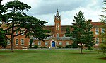 More images |
Grade II*
| Name | Location | Type | Completed [note 1] | Date designated | Grid ref.[note 2] Geo-coordinates | Entry number [note 3] | Image |
|---|---|---|---|---|---|---|---|
| Carshalton House | Carshalton | House | 1696–1713 | 16 March 1954 | TQ2755164460 51°21′54″N 0°10′09″W / 51.364891°N 0.169211°W / 51.364891; -0.169211 (Carshalton House) | 1065627 |  More images |
| Church of All Saints | Carshalton | Church | 12th century | 16 March 1954 | TQ2798464469 51°21′54″N 0°09′47″W / 51.364874°N 0.162992°W / 51.364874; -0.162992 (Church of All Saints) | 1065683 |  More images |
| Church of All Saints | Sutton | Church | 19th century | 28 August 1953 | TQ2586165281 51°22′22″N 0°11′35″W / 51.372646°N 0.193184°W / 51.372646; -0.193184 (Church of All Saints) | 1065697 |  More images |
| Church of St Dunstan | Cheam, Sutton | Church | 13th century | 26 January 1971 | TQ2428263916 51°21′39″N 0°12′59″W / 51.360726°N 0.216333°W / 51.360726; -0.216333 (Church of St Dunstan) | 1065676 |  More images |
| Hermitage or Grotto at Carshalton House | Carshalton | Grotto | Before 1721 | 16 March 1954 | TQ2760764379 51°21′51″N 0°10′06″W / 51.36415°N 0.168437°W / 51.36415; -0.168437 (Hermitage or Grotto at Carshalton House) | 1357608 |  |
| No. 19 Park Hill | Sutton | House | c. 1867 | 1 March 1974 | TQ2755064024 51°21′40″N 0°10′10″W / 51.360973°N 0.169382°W / 51.360973; -0.169382 (No. 19 Park Hill) | 1183738 |  |
| Parish Church of St Mary the Virgin | Beddington, Sutton | Church | 14th or 15th century | 21 January 1954 | TQ2956865249 51°22′17″N 0°08′24″W / 51.371525°N 0.139968°W / 51.371525; -0.139968 (Parish Church of St Mary the Virgin) | 1065670 |  More images |
| Pigeon House to North West of Beddington Place | Beddington, Sutton | Dovecote | Early 18th century | 21 January 1954 | TQ2954165374 51°22′22″N 0°08′25″W / 51.372655°N 0.14031°W / 51.372655; -0.14031 (Pigeon House to North West of Beddington Place) | 1065674 | 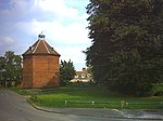 More images |
| Remains of Old Church of St Dunstan, Now known as the Lumley Chapel | Cheam, Sutton | Church | 12th century | 28 August 1953 | TQ2429963900 51°21′38″N 0°12′58″W / 51.360578°N 0.216095°W / 51.360578; -0.216095 (Remains of Old Church of St Dunstan, Now known as the Lumley Chapel) | 1183440 |  More images |
| Water Pavilion at Carshalton House | Carshalton | Orangery | Before 1721 | 16 March 1954 | TQ2771464483 51°21′54″N 0°10′01″W / 51.365061°N 0.166863°W / 51.365061; -0.166863 (Water Pavilion at Carshalton House) | 1183926 |  More images |
| Whitehall | Cheam, Sutton | House | 16th century | 28 August 1953 | TQ2422463766 51°21′34″N 0°13′02″W / 51.35939°N 0.217218°W / 51.35939; -0.217218 (Whitehall) | 1357580 |  More images |
| Church of St Nicholas | St Nicholas Road, Sutton | Church | 1864 | 1 March 1974 | TQ2577164158 51°21′45″N 0°11′42″W / 51.362573°N 0.19487285°W / 51.362573; -0.19487285 (Church of St Nicholas) | 1065629 | 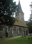 More images |
Grade II
| Name | Location | Type | Completed [note 1] | Date designated | Grid ref.[note 2] Geo-coordinates | Entry number [note 3] | Image |
|---|---|---|---|---|---|---|---|
| Trinity Church | Cheam Road, Sutton | Church | 1907 | 1 March 1974 | TQ2561364111 51°21′42″N 0°11′44″W / 51.361667°N 0.195556°W / 51.361667; -0.195556 (Trinity Church) | 1200708 |  More images |
Notes
- ^ a b c The date given is the date used by Historic England as significant for the initial building or that of an important part in the structure's description.
- ^ a b c Sometimes known as OSGB36, the grid reference is based on the British national grid reference system used by the Ordnance Survey.
- ^ a b c The "List Entry Number" is a unique number assigned to each listed building and scheduled monument by Historic England.
External links
 Media related to Grade I listed buildings in the London Borough of Sutton at Wikimedia Commons
- Media related to Grade II* listed buildings in the London Borough of Sutton at Wikimedia Commons
- v
- t
- e
- Bandonhill
- Beddington
- Beddington Corner
- Belmont
- Benhill
- Benhilton
- Carshalton
- Cheam (including Cheam Village and North Cheam)
- Hackbridge
- Little Woodcote
- Rosehill
- Roundshaw
- South Beddington
- St Helier
- Sutton (principal town)
- Sutton Common
- Wallington
- Woodcote Green
- Worcester Park
- The Wrythe


- Beddington Farmlands
- Beddington Park
- Carshalton Park
- Grove Park
- Manor Park, Sutton
- Mayfield Lavender
- Nonsuch Park
- Oaks Park
- Carshalton and Wallington
- Sutton and Cheam

- Council
- Grade I and II* listed buildings
- People
- Public art
- Schools
 Category
- Commons

Portals:
 London
 Architecture


