Great Plain, Danbury, Connecticut
Former farming community in Danbury, Connecticut, United States
Unincorporated area in Connecticut, United States
41°25′17.69″N 73°26′20.18″W / 41.4215806°N 73.4389389°W / 41.4215806; -73.4389389[1] United States
 Connecticut
Great Plain is an unincorporated area in the City of Danbury, Fairfield County, Connecticut.[1] A former farming community, only remnants exist of this once thriving agricultural hub. It is located in the northeast section of the city, sharing a border with the Beaverbrook area of Danbury and Brookfield, CT.
History

Named for its broad expanse, Great Plain gained a reputation for fruitful fields and prosperous farmers.[2]
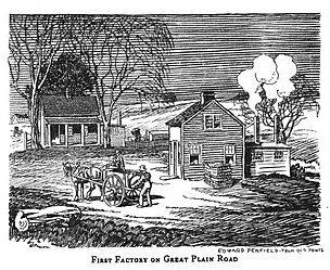
The original Mallory Hat Company, which would become one of Danbury's most prominent hat manufacturers, was established in Great Plain in 1823.[3] At this time, Danbury was in the early stages of becoming the "Hat City of the World" [4] The small shop operated at Great Plain until the 1850s, when Mallory decided to relocate downtown.[5]
Chapel
Great Plain Union Chapel was constructed in 1890. The highly ornamented Victorian Vernacular style building cost $1,100 to build.[6] For a time, it was the centerpiece of the neighborhood but eventually began deteriorating. It has been noted as in need of repair dating back to 1961, when there was an effort to restore the building.[7] Despite past efforts, it remains dilapidated today.
Schoolhouse

Built in 1856, the Greek Revival one-room schoolhouse served the students of the Great Plain community until the 1940s. In 1954 the City of Danbury transferred the building to the Great Plain District Association, a neighborhood organization with plans to convert it into a community center. In February 1955, 75 residents from the neighborhood joined in a housewarming for its opening.[8] The Old Great Plain School is one of only three one-room schoolhouses still standing in Danbury.[6]
Candlewood Lake
Communities
- Aqua Vista
- Boulder Ridge
- Candlewood Vista
- Cedar Heights
- Driftwood Point
- Hawthorne Terrace
- Lattins Landing
- Pleasant Acres
- Snug Harbor
- Ta'agan Point
References
- ^ a b "Great Plain". Geographic Names Information System. United States Geological Survey, United States Department of the Interior.
- ^ Bailey, James M. (1896). History of Danbury, Conn., 1684-1896. Retrieved April 19, 2022.
- ^ Connecticut General Assembly (1903). Public Documents of the State of Connecticut, Volume 1. Hartford: State of Connecticut. p. 239. Retrieved March 31, 2022.
- ^ Pirro, John (February 1, 2011). "The rise—and fall—of hatting in Danbury". Danbury News-Times. Retrieved April 19, 2022.
- ^ Woolley, Edward Mott (1923). A Century of Hats and the Hats of the Century. p. 7. Retrieved April 19, 2022.
- ^ a b Devlin, William E. "Historic Resources Inventory" (PDF). Danbury Preservation Trust. pp. 10–14. Retrieved March 31, 2022.
- ^ "Restoration of Chapel is Nearing Completion". Bridgeport Press. July 10, 1961. Retrieved February 28, 2022.
- ^ "Do You Remember?". Danbury News-Times. February 26, 2005. Retrieved April 19, 2022.
 Connecticut portal

- v
- t
- e
- Danbury Fair
- Danbury Hospital
- Danbury Ice Arena
- Danbury Museum and Historical Society
- Rogers Park
- The Summit at Danbury
| NRHP |
|---|

- Beaverbrook
- Beckettville
- Germantown
- Great Plain
- Hayestown
- Long Ridge
- King Street
- Mill Plain
- Miry Brook
- Pembroke
- Current
- Danbury Hat Tricks
- Danbury Westerners
- Former
- Connecticut Whale
- Danbury Mad Hatters
- Danbury Titans
- Danbury Trashers
- Danbury Whalers
- New England Stars
 | This Connecticut state location article is a stub. You can help Wikipedia by expanding it. |
- v
- t
- e


