Guaviare River
River in Colombia
| Guaviare | |
|---|---|
 The Guaviare River as seen from the air | |
| Location | |
| Country | Colombia |
| Physical characteristics | |
| Source | |
| • location | Ariari and Guayabero Rivers |
| Mouth | |
• location | The Orinoco |
| Length | 1,497 km (930 mi) |
| Basin size | 140,000 km2 (54,000 sq mi) |
| Discharge | |
| • average | 8,200 m3/s (290,000 cu ft/s) |
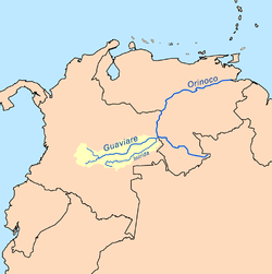
The Guaviare is a tributary of the Orinoco in Colombia. It flows together with the upper Orinoco (until here also called Río Parágua), which it clearly surpasses in length (altogether about 1760 km) and water flow. Thus, the Guaviare is hydrologically the main stream of the Orinoco system.[1]
The Guaviare has its source in two other rivers, the Ariari and the Guayabero, which in turn have their own sources in the eastern part of the Andes. At 1,497 kilometres (930 mi) long, it is the longest tributary of the Orinoco and is navigable for 630 kilometres (390 mi) of its total length. The Guaviare is considered the border between the Llanos and the Amazon Rainforest. Its main tributary is the Inírida River.
References
- ^ Silva León, Gustavo. "La cuenca del río Orinoco: visión hidrográfica y balance hídrico". Revista Geográfica Venezolana. 46 (1) 2005: 75–108.
- The information in this article is based on a translation of its German equivalent.
External links
- (in Spanish) Territorial-Environmental Information System of Colombian Amazon SIAT-AC website
4°02′34″N 67°42′41″W / 4.0427°N 67.7115°W / 4.0427; -67.7115

Authority control databases | |
|---|---|
| International |
|
| National |
|
 | This article related to a river in Colombia is a stub. You can help Wikipedia by expanding it. |
- v
- t
- e


