Gug Tappeh, Urmia
Village in West Azerbaijan province, Iran
Village in West Azerbaijan, Iran
Gug Tappeh Persian: گوگتپه | |
|---|---|
Village | |
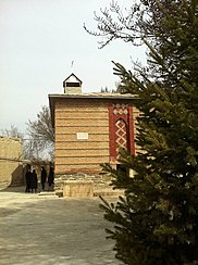
 Assyrian St. Zayya church in Gug Tappeh | |
| 37°31′02″N 45°08′40″E / 37.51722°N 45.14444°E / 37.51722; 45.14444[1] | |
| Country | Iran |
| Province | West Azerbaijan |
| County | Urmia |
| District | Central |
| Rural District | Baranduzchay-ye Shomali |
| Population (2016)[2] | |
| • Total | 2,850 |
| Time zone | UTC+3:30 (IRST) |
Gug Tappeh (Persian: گوگتپه)[a] is a village in Baranduzchay-ye Shomali Rural District of the Central District of Urmia County, West Azerbaijan province, Iran.
Demographics
Population
At the time of the 2006 National Census, the village's population was 1,804 in 482 households.[4] The following census in 2011 counted 2,439 people in 706 households.[5] The 2016 census measured the population of the village as 2,850 people in 836 households. It was the most populous village in its rural district.[2]
Notable people
- Malek-Yonan family
- George Malek-Yonan
- Rosie Malek-Yonan
- Terrence Malick
Gallery
-
 Assyrian Christian Family from Gug Tappeh.
 -
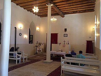
 Assyrian church in Gug Tappeh.
 -
 Assyrian Christian Festival in Gug Tappeh.
 -
 St. Zayya Church in Gug Tappeh.


See also
 Iran portal
Notes
References
- ^ OpenStreetMap contributors (10 March 2023). "Gug Tappeh, Urmia County" (Map). OpenStreetMap (in Persian). Retrieved 10 March 2023.
- ^ a b "Census of the Islamic Republic of Iran, 1395 (2016)". AMAR (in Persian). The Statistical Center of Iran. p. 04. Archived from the original (Excel) on 30 August 2022. Retrieved 19 December 2022.
- ^ Gug Tappeh can be found at GEOnet Names Server, at this link, by opening the Advanced Search box, entering "-3065292" in the "Unique Feature Id" form, and clicking on "Search Database".
- ^ "Census of the Islamic Republic of Iran, 1385 (2006)". AMAR (in Persian). The Statistical Center of Iran. p. 04. Archived from the original (Excel) on 20 September 2011. Retrieved 25 September 2022.
- ^ "Census of the Islamic Republic of Iran, 1390 (2011)". Syracuse University (in Persian). The Statistical Center of Iran. p. 04. Archived from the original (Excel) on 20 January 2023. Retrieved 19 December 2022.
- v
- t
- e
West Azerbaijan province, Iran

and cities

 | This Urmia County location article is a stub. You can help Wikipedia by expanding it. |
- v
- t
- e


