Hall i' th' Wood
Building in Greater Manchester, England
53°36′02″N 2°25′08″W / 53.60049°N 2.41895°W / 53.60049; -2.41895 Listed Building – Grade I

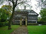
Hall i' th' Wood is an early 16th-century manor house in Bolton in the historic county of Lancashire and the ceremonial county of Greater Manchester, England. It is a Grade I listed building and is currently used as a museum by Bolton Metropolitan Borough Council.[1][2] It was the manor house for the moiety of the Tonge with Haulgh township held by the Brownlows in the 16th century. The original building is timber framed and has a stone flagged roof; there were later additions to the house, built from stone, in 1591 and 1648.[1] The name represents "Hall in the Wood' spoken in the local regional English dialect and is pronounced /ˌɔːlɪθˈwʊd/.
The house was not used as a gentry house but rather given over to multiple occupation by families engaged in industry. Four (previously five) separate dwellings can be identified, each with its own entrance and staircase.[3] One part was let to Samuel Crompton during the 18th century, where he designed and built the first spinning mule.[2] About 1779, Crompton succeeded in producing a mule-jenny, a machine which spun yarn suitable for use in the manufacture of muslin.[4] It was known as the muslin wheel or the Hall i' th' Wood wheel[5] from the name of the house.[6]
Hall i' th' Wood was bought by William Lever (later Lord Leverhulme) in 1899 and was restored by Jonathan Simpson and Edward Ould.[7] Lever gave the house to the Corporation of Bolton in 1900.[1]
An episode of the television programme Most Haunted was filmed in the hall in 2008.[8]
In Fisher's Drawing Room Scrap Book, 1833, is a poetical illustration by Letitia Elizabeth Landon to an engraving of a painting of the hall by William Linton.[9] This dwells on the changes the hall has seen over the centuries.
Wikisource has original text related to this article:
Hall i' th' Wood,
a poetical illustration
by L. E. L.
a poetical illustration
by L. E. L.
See also
 Greater Manchester portal

- Grade I listed buildings in Greater Manchester
- Listed buildings in Bolton
- Hall i' th' Wood railway station
References
- ^ a b c Historic England. "Hall i' th' Wood, Bolton (1388052)". National Heritage List for England. Retrieved 19 July 2012.
- ^ a b Historic England. "Hall i' th' Wood (44392)". Research records (formerly PastScape). Retrieved 19 July 2012.
- ^ Hartwell, Clare. Lancashire: Manchester and the South-East. p. 153.
- ^ Baines, Edward (1835), History of the cotton manufacture in Great Britain, London: H. Fisher, R. Fisher, and P. Jackson
- ^ Baines, Edward (1835), History of the cotton manufacture in Great Britain, London: H. Fisher, R. Fisher, and P. Jackson
- ^ "Samuel Crompton 1753–1827". Retrieved 21 April 2008.
- ^ Hartwell, Clare; Hyde, Matthew; Pevsner, Nikolaus (2004), Lancashire: Manchester and the South-East, The Buildings of England, New Haven and London: Yale University Press, pp. 153–155, ISBN 0-300-10583-5
- ^ Karl Beattie and Bev Parr (directors) (2008). Most Haunted (TV-Series). Hall i' th' Wood: Antix Productions.
- ^ Landon, Letitia Elizabeth (1832). "picture". Fisher's Drawing Room Scrap Book, 1833. Fisher, Son & Co.Landon, Letitia Elizabeth (1832). "poetical illustration". Fisher's Drawing Room Scrap Book, 1833. Fisher, Son & Co.
External links
![]() Media related to Hall i' th' Wood at Wikimedia Commons
Media related to Hall i' th' Wood at Wikimedia Commons
- Hall i' th' Wood - history and visitor information, Bolton Museums and Archive Service
- Hall i' th' Wood at bolton.org
- Extract from A Short History of Hall i' th' Wood Compiled and Edited by Derek R. Mills (1992)
- v
- t
- e
Buildings and structures in the Metropolitan Borough of Bolton, England
- Astley Bridge Mill
- Bolton Town Hall
- Bolton Museum
- Bolton Steam Museum
- Bolton Union Mill
- Century Mill
- Eagley Mills
- Farnworth Town Hall
- 10 Firwood Fold
- 15 Firwood Fold
- Hall i' th' Wood
- Horwich Works
- Little Bolton Town Hall
- Kearsley Mill
- Lostock Hall Gatehouse
- Smithills Hall
- Swan Lane Mills
- Ye Olde Man & Scythe


- Bolton College
- Bolton Muslim Girls' School
- Bolton St Catherine's Academy
- Bolton School
- Bolton Sixth Form College
- Bolton TIC
- Canon Slade School
- Darul Uloom Bolton
- Essa Academy
- Harper Green School
- Kearsley Academy
- Ladybridge High School
- Little Lever School
- Mount St Joseph School
- Rivington and Blackrod High School
- St James's Church of England High School
- St Joseph's RC High School
- Sharples School
- Smithills School
- Thornleigh Salesian College
- Turton School
- University Collegiate School
- University of Bolton
- Westhoughton High School
- Bolton Royal Infirmary
- Burnden Park
- Chequerbent railway station
- Chequerbent railway station (1831)
- Daubhill railway station
- Grundy Hill
- Horwich railway station
- Lostock Junction Mills
- Westhoughton Mill
53°36′00″N 2°25′08″W / 53.600°N 2.419°W / 53.600; -2.419


