Kaunas Reservoir
Reservoir in Lithuania
54°51′10″N 24°10′02″E / 54.85278°N 24.16722°E / 54.85278; 24.16722Kaunas Reservoir (Lithuanian: Kauno marios, Kaunas Lagoon, Kaunas Sea) is the largest Lithuanian artificial lake, created in 1959 by damming the Nemunas River near Kaunas and Rumšiškės. It occupies 63.5 square kilometers, which is about 0.1% of the total territory of Lithuania. The reservoir supports the operations of the Kaunas Hydroelectric Power Plant. Its waters cover the Nemunas valley from the river's confluence with Strėva River to the dam, a distance of about 25 kilometers. At its widest, the reservoir is 3.3 kilometers across and its greatest depth is 22 meters.[1]
The reservoir also supports the operations of 900MW Kruonis Pumped Storage Plant, which is situated near confluence with Strėva River.
In 1992, in order to protect the local environment and cultural heritage, Kaunas Reservoir Regional Park was established. A yacht club operates in the park.[2]
Gallery
-
 Map of flooded villages
 -
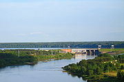 Hydroelectric power plant
 -
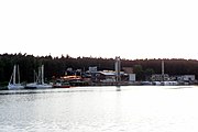 Kaunas Yacht Club


Sites flooded by the Kaunas Reservoir
In anticipation of the reservoir's creation, 721 farms and villages were moved to various locations.
|
|
References
- v
- t
- e


