Kelheim (district)
District in Bavaria, Germany

Flag

Coat of arms

(31 December 2022)[1]
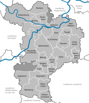
Kelheim is a Landkreis (district) in Bavaria, Germany, bound (from the north and clockwise) by the districts Regensburg, Landshut, Freising, Pfaffenhofen, Eichstätt and Neumarkt.
Geography

The district is located halfway between Ingolstadt and Regensburg on both banks of the Danube. In the northwestern part it includes a part of the Altmühl Valley Nature Park and the confluence of Altmühl and Danube.
Coat of arms
The coat of arms displays:
- the blue and white checked pattern of Bavaria
- the roses symbolise the monasteries of Biburg and Weltenburg
- silver and black are the colours of Abensberg, which once was a free imperial city
Towns and municipalities
| Towns | Municipalities | |
|---|---|---|
References
- ^ Genesis Online-Datenbank des Bayerischen Landesamtes für Statistik Tabelle 12411-003r Fortschreibung des Bevölkerungsstandes: Gemeinden, Stichtag (Einwohnerzahlen auf Grundlage des Zensus 2011).
External links
Wikimedia Commons has media related to Landkreis Kelheim.
- Official website (German)
- Altmühltal Nature Park (German, English)
- v
- t
- e
Urban and rural districts in the Free State of Bavaria in Germany
districts
- Amberg
- Ansbach
- Aschaffenburg
- Augsburg
- Bamberg
- Bayreuth
- Coburg
- Erlangen
- Fürth
- Hof
- Ingolstadt
- Kaufbeuren
- Kempten
- Landshut
- Memmingen
- München (Munich)
- Nürnberg (Nuremberg)
- Passau
- Regensburg
- Rosenheim
- Schwabach
- Schweinfurt
- Straubing
- Weiden
- Würzburg
districts
- Aichach-Friedberg
- Altötting
- Amberg-Sulzbach
- Ansbach
- Aschaffenburg
- Augsburg
- Bad Kissingen
- Bad Tölz-Wolfratshausen
- Bamberg
- Bayreuth
- Berchtesgadener Land
- Cham
- Coburg
- Dachau
- Deggendorf
- Dillingen
- Dingolfing-Landau
- Donau-Ries
- Ebersberg
- Eichstätt
- Erding
- Erlangen-Höchstadt
- Forchheim
- Freising
- Freyung-Grafenau
- Fürstenfeldbruck
- Fürth
- Garmisch-Partenkirchen
- Günzburg
- Haßberge
- Hof
- Kelheim
- Kitzingen
- Kronach
- Kulmbach
- Landsberg
- Landshut
- Lichtenfels
- Lindau
- Main-Spessart
- Miesbach
- Miltenberg
- Mühldorf
- München (Munich)
- Neuburg-Schrobenhausen
- Neumarkt
- Neustadt (Aisch)-Bad Windsheim
- Neustadt an der Waldnaab
- Neu-Ulm
- Nürnberger Land
- Oberallgäu
- Ostallgäu
- Passau
- Pfaffenhofen
- Regen
- Regensburg
- Rhön-Grabfeld
- Rosenheim
- Roth
- Rottal-Inn
- Schwandorf
- Schweinfurt
- Starnberg
- Straubing-Bogen
- Tirschenreuth
- Traunstein
- Unterallgäu
- Weilheim-Schongau
- Weißenburg-Gunzenhausen
- Wunsiedel
- Würzburg
Towns and municipalities in Kelheim (district) | ||
|---|---|---|
 | ||
48°50′N 11°50′E / 48.83°N 11.83°E / 48.83; 11.83
Authority control databases | |
|---|---|
| International |
|
| National |
|
| Other |
|


