Khathiar–Gir dry deciduous forests
Ecoregion in India
24°48′N 75°48′E / 24.8°N 75.8°E / 24.8; 75.8[1]
The Khathiar–Gir dry deciduous forests (also Kathiarbar-Gir or Kathiawar-Gir) is a mostly arid ecoregion in northwestern India that stretches over 103,100 sq mi (267,000 km2) across Gujarat, Rajasthan and Madhya Pradesh. The dry deciduous forests in the region are dominated by teak, and thorny trees and scrub in drier areas.[3]
Landscape

The Khathiar–Gir dry deciduous forests include the Aravalli Range, the high point of which is Mount Abu with an elevation of 1,721 m (5,646 feet), and a small part of the Northwestern thorn scrub forests in the west. In the west is the Kathiawar Peninsula and the strip of western Rajasthan between the Aravalli Range and Thar Desert. To the northwest, the Kathiawar-Gir dry deciduous forests transit to the Upper Gangetic Plains moist deciduous forests. To the southeast lies the Narmada Valley dry deciduous forests, of the Vindhya Range, and the Narmada River Valley. The ecoregion also borders the North Western Ghats moist deciduous forests in southeastern Gujarat.[citation needed]
The ecoregion has a tropical monsoon climate, with most of its 550 to 700 mm average annual rainfall during the June–September southwest monsoon and little for the remaining months of the year, while temperatures often exceed 40 °C. Higher elevations of the Aravallis stay cooler, and the windward slopes (generally southeast-facing) receive higher rainfall. This results in a dry landscape of thorny scrub, bare trees and rocks.[3]
Flora

The composition of the ecoregion's forests varies with moisture and soil. They have a three-storied structure, with the top story reaching 15 to 25 m (49 to 82 ft). Arid areas are dominated by Anogeissus pendula growing in association with khair, especially on the quartzite ridges and gneiss hillocks of the Aravalli Range. Less arid areas are dominated by teak (Tectona grandis), bael (Aegle marmelos), Boswellia serrata, Desmodium oojeinense, Diospyros species, silk-cotton tree, Sterculia urens, Phyllanthus emblica, Dalbergia paniculata, and Terminalia elliptica. Mount Abu is covered in dry deciduous forest with conifers at the highest elevations. Thorn scrub forests, characterized by Euphorbia caducifolia, Maytenus emarginata, Acacia senegal, Commiphora mukul, Wrightia tinctoria, Flueggea leucopyrus, Grewia species, occur on rocky Aravalli hillsides and in degraded areas. The endemic species Dicliptera abuensis, Strobilanthes halbergii, and Veronica anagallis also grow in these areas. Date palms (Phoenix sylvestris) and fig trees (Ficus racemosa) grow near rivers and streams of the hills.[3]
Fauna
- endangered great Indian bustard (Ardeotis nigriceps)
- lesser florican (Eupodotis indica)
- near-endemic white-naped tit (Parus nuchalis), which inhabits the thorny scrub areas of the ecoregion.
The protected areas of this region are also home to 80 mammal species including[3]
- Indian leopard (Panthera pardus fusca), Indian wolf (Canis lupus pallipes), striped hyena (Hyaena hyaena), four-horned antelope (Tetracerus quadricornis), blackbuck (Antilope cervicapra), and chinkara (Gazella bennettii)
- jungle cat (Felis chaus), Asiatic wildcat (Felis silvestris ornata) and rusty-spotted cat (Prionailurus rubiginosus).[4]
- golden jackal (Canis aureus)[5]
- Bengal tiger (Panthera tigris tigris) in the eastern part of this ecoregion[6]
- Asiatic lion (Panthera leo leo) in Gir National Park and surrounding areas in Kathiawar Peninsula[7]
- Sloth bear (Melursus ursinus) in Ratan Mahal Wildlife Sanctuary[8]
-
 Bengal tiger in Ranthambore National Park, Rajasthan
 -
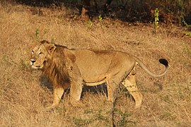 Male Asiatic lion in Gir Forest National Park, Gujarat
 -
 Indian leopard at Gir
 -
 Striped hyena
 -
 Golden jackal in the area of Rajkot
 -
 An Indian sloth bear walking on the road in Ratan Mahal Sloth Bear Sanctuary
 -
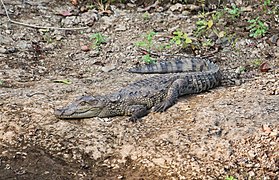 Mugger crocodile at Gir
 -
 Great Indian bustard at the Naliya grasslands, Kutch
 -
 White-naped tit foraging on Prosopis juliflora at Kutch
 -
 A female lesser florican in flight from Rajasthan


Threats to biodiversity
The human population in the region is growing, and wildlife habitats have mostly been removed or degraded due to collection of firewood and timber, and use as grazing land for livestock.[citation needed]
Protected areas
Protected areas cover 8,980 km2 (3,470 sq mi) in this ecoregion, and include:[3]
- Balaram Ambaji Wildlife Sanctuary
- Darrah National Park (including Jawahar Sagar Wildlife Sanctuary and National Chambal Sanctuary)
- Gandhi Sagar Sanctuary
- Ghatigaon Wildlife Sanctuary
- Gir Forest National Park
- Jaisamand Wildlife Sanctuary
- Jambughoda Wildlife Sanctuary
- Kumbhalgarh Wildlife Sanctuary
- Kuno National Park
- Madhav National Park
- Mount Abu Wildlife Sanctuary
- Nahargarh Biological Park
- Ramgarh Wildlife Sanctuary
- Ranthambore National Park
- Ratan Mahal Wildlife Sanctuary
- Sailana Kharmour Bird Sanctuary
- Sariska Tiger Reserve
- Sita Mata Wildlife Sanctuary
See also
References
- ^ World Database on Protected Areas (2019). "Darrah in India". Protected Planet United Nations Environment World Conservation Monitoring Centre.[permanent dead link]
- ^ Eric Dinerstein, David Olson, et al. (2017). An Ecoregion-Based Approach to Protecting Half the Terrestrial Realm, BioScience, Volume 67, Issue 6, June 2017, Pages 534–545; Supplemental material 2 table S1b. [1]
- ^ a b c d e f "Khathiar-Gir Dry Deciduous Forests". Terrestrial Ecoregions. World Wildlife Fund. Retrieved 14 February 2017.
- ^ Pathak, B. J. (1990). "Rusty-spotted Cat Felis rubiginosa Geoffroy: a new record for Gir Wildlife Sanctuary and National Park". Journal of the Bombay Natural History Society (87): 8.
- ^ Alam, M. S.; Khan, J. A.; Njoroge, C. H.; Kumar, S.; Meena, R. L. (2015). "Food preferences of the Golden Jackal Canis aureus in the Gir National Park and Sanctuary, Gujarat, India". Journal of Threatened Taxa. 7 (2): 6927–6933. doi:10.11609/jott.o3954.6927-33.
- ^ Jhala, Y. V.; Qureshi, Q.; Sinha, P. R., eds. (2011). Status of tigers, co-predators and prey in India, 2010. TR 2011/003 pp-302 (PDF). New Delhi, Dehradun: National Tiger Conservation Authority, Govt. of India, and Wildlife Institute of India. Archived from the original (PDF) on 20 January 2012.
- ^ Singh, H. S.; Gibson, L. (2011). "A conservation success story in the otherwise dire megafauna extinction crisis: The Asiatic lion (Panthera leo persica) of Gir forest" (PDF). Biological Conservation. 144 (5): 1753–1757. doi:10.1016/j.biocon.2011.02.009.
- ^ Garshelis, D. L.; Joshi, A. R.; Smith, J. L. D. & Rice, C. G. "Sloth Bear Conservation Action Plan". Bears: status survey and conservation action plan (PDF). Gland: IUCN. pp. 225–240. Archived from the original (PDF) on 23 July 2011. Retrieved 18 April 2011.
External links
Wikimedia Commons has media related to Khathiar-Gir dry deciduous forests.
- "Khathiar-Gir dry deciduous forests". Terrestrial Ecoregions. World Wildlife Fund.
- v
- t
- e
subtropical
Forests
Forests
| Himalayan Broadleaf | |
|---|---|
| Himalayan Subalpine conifer |
Shrublands,
and
Savannas
| Tropical and subtropical | |||||
|---|---|---|---|---|---|
| Montane |
| ||||
| Flooded | |||||
| Deserts and Xeric |


