Koekelberg
Municipality of the Brussels-Capital Region, Belgium
Municipality in Belgium

Flag

Coat of arms
Location of Koekelberg


Koekelberg
Location in Belgium 
Koekelberg municipality in the Brussels-Capital Region

 Belgium
French Community
(2020-01-01)[1]
1081
21011
Koekelberg (French: [kukœlbɛʁ(ɡ)], Dutch: [ˈkukəlˌbɛr(ə)x] ⓘ) is one of the 19 municipalities of the Brussels-Capital Region, Belgium. Located in the north-western part of the region, it is bordered by Berchem-Sainte-Agathe, Ganshoren, Jette, and Molenbeek-Saint-Jean. In common with all of Brussels' municipalities, it is legally bilingual (French–Dutch).
As of 1 January 2022[update], the municipality had a population of 22,023 inhabitants, the smallest in the region.[2] The total area is 1.18 km2 (0.46 sq mi), which gives a population density of 15,543/km2 (40,260/sq mi).[2]
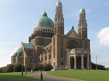
The municipality is dominated by the National Basilica of the Sacred Heart (or Koekelberg Basilica), one of the largest Roman Catholic churches in the world.[3] Its main transportation hub are the connected Simonis and Elisabeth metro stations, served by the Brussels Intercommunal Transport Company (STIB/MIVB) system.
Politics
The current city council was elected in the October 2018 elections.[4] The current mayor of Koekelberg is Ahmed Laaouej, a member of PS, who is in coalition on the municipal council with Ecolo - Groen and Alternative Humaniste.
Main sights
- The Municipal Hall of Koekelberg, located on the Place Henri Vanhuffel/Henri Vanhuffelplein. Built in 1882, it was fitted with a geometric Art Deco facade designed by the architect Henri-Aimé Jacobs in 1938.[5]
- The National Basilica of the Sacred Heart (or Koekelberg Basilica), a minor basilica and parish church, as well as one of the largest churches by area in the world.[3] Completed only in 1969, and combining Art Deco with neo-Byzantine elements, its cupola provides a panoramic view of Brussels and its outskirts.
- Lefever House, an early 20th-century (1913) Art Nouveau town house built by the architect Fernand Lefever, which has been listed as a protected monument since 2006.[6]
- Finally, the municipality maintains several green areas, including Elisabeth Park and Victoria Park.
-
 Lefever House (1913)
 -
-
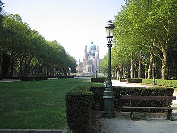 Elisabeth Park


References
Citations
- ^ "Bevolking per gemeente op 1 januari 2020". Statbel.
- ^ a b "Koekelberg | IBSA". ibsa.brussels. Retrieved 5 January 2023.
- ^ a b Stéphany 2006, p. 63.
- ^ "Résultats officiels des élections communales 2018" (in French). Retrieved 17 July 2021.
- ^ "maison communal – Inventaire du patrimoine architectural". monument.heritage.brussels (in French). Retrieved 4 June 2023.
- ^ "Maison personnelle de l'architecte Fernand Lefever – Inventaire du patrimoine architectural". monument.heritage.brussels (in French). Retrieved 4 June 2023.
Bibliography
- Stéphany, Pierre (2006). "Bruxelles. La basilique de Koekelberg". La Belgique en cent coups d'oeil (in French). Tielt: Lanno Publishers. ISBN 2-87386-445-1.
External links
 Belgium portal
Places adjacent to Koekelberg | |
|---|---|


- v
- t
- e
| Historical events |
|  |
|---|---|---|
| Administration | ||
| Transport | ||
| Symbols | ||
| Other topics | ||
| Lists |
|
 Belgium portal
Authority control databases | |
|---|---|
| International |
|
| National |
|
| Geographic |
|


