Koudekerke
Village in Zeeland, Netherlands

Coat of arms
51°29′51″N 3°33′10″E / 51.49750°N 3.55278°E / 51.49750; 3.55278
(2021)[1]
4371[1]
Koudekerke (Zeelandic: Koukerke) is a village in the region of Walcheren in the Dutch province of Zeeland. It is a part of the municipality of Veere. As of 2018[update], the census reported the village has a population of 3,419, making it the largest settlement in Veere.[3] The built-up area of the village was 0.55 km², and contained 1,133 residences.[4]
History
The village was first mentioned between 1181 and 1210 as Coldekirca, and means "abandoned church".[5] Koudekerke is a circular church village which developed in the Middle Ages on a ridge.[6]
The Dutch Reformed church is an aisleless church with ridge turret which was built in the mid-17th century as a replacement of the medieval church. Huis der Boede is manor house built in 1733 Louis XIV style on the location of a 13th-century estate. In 1950, it became a retirement home. The carriage house was demolished in 1970.[6]
Koudekerke was home to 1.211 people in 1840.[7] On 1 November 1941, part of the Koudekerke was annexed by Middelburg.[8] In 1944, the land was inundated and the population was evacuated.[7]
After World War II, it became a commuter village. The nearby hamlet of Dishoek became the tourist centre due to its beaches, and contains holiday homes, campsites and hotels.[8] Koudekerke was an independent municipality until 1966, when it was merged into Valkenisse. In 1997, it was merged into Veere.[7]
Gallery
-
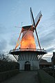 Windmill "De Lelie"
 -
 Farmhouse at Dishoekseweg
 -
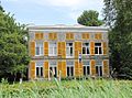 Huis Moesbosch
 -
 German Bunker from WWII in Koudekerke


See also
References
- ^ a b c "Kerncijfers wijken en buurten 2021". Central Bureau of Statistics. Retrieved 22 April 2022.
three entries
- ^ "Postcodetool for 4371AA". Actueel Hoogtebestand Nederland (in Dutch). Het Waterschapshuis. 24 July 2019. Retrieved 22 April 2022.
- ^ "Feiten en cijfers - Bestuur - Gemeente Veere". Archived from the original on 2018-09-06. Retrieved 2018-02-01.
- ^ Statistics Netherlands (CBS), Bevolkingskernen in Nederland 2001 [1] Archived 2007-01-24 at the Wayback Machine. (Statistics are for the continuous built-up area).
- ^ "Koudekerke - (geografische naam)". Etymologiebank (in Dutch). Retrieved 22 April 2022.
- ^ a b Piet van Cruyningen & Ronald Stenvert (2003). Koudekerke (in Dutch). Zwolle: Waanders. ISBN 90-400-8830-6. Retrieved 22 April 2022.
- ^ a b c "Koudekerke (Walcheren)". Plaatsengids (in Dutch). Retrieved 22 April 2022.
- ^ a b "Koudekerke". Zalig Zeeland (in Dutch). 2 December 2018. Retrieved 22 April 2022.
| Authority control databases |
|
|---|


