Larmer Bay ruin

Larmer Bay ruin is a ruin in Larmer Bay, on the north side of Tortola in the British Virgin Islands. The ruin dates from the sugar plantation era, and was presumed abandoned during the economic collapse of the British Virgin Islands during the mid-19th century.[1]
The ruins are difficult to access, as no roads lead down to the bay, and the ghuts leading down the mountain side are relatively steep. The bay is not accessible by sea due to the coral reefs lying close to the shore, and the strong north side swells. However, a road from the nearby housing development descends to within a couple of hundred feet of the bay, and a dirt track leads down to the beach, making it possible to see the ruins without cutting a path.[2]
The ruin has never been academically studied, and there is almost no historical record of the ruin. It is presumed to be one of the many relatively impoverished sugar plantations that fell into financial distress after the United Kingdom passed the Sugar Duties Act 1846, and was most likely abandoned after the insurrection of 1853.
The ruin is one of the largest (if not the largest) plantation era ruin surviving in the British Virgin Islands. Remains of copper vats and grinding equipment can still be seen on the site.
Images
-
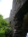
 The sea-facing walls
 -
 Sea-facing entrance
 -
 East side of the ruin, looking out to sea
 -
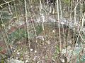 Location of the copper vat
 -
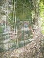
 Examples of imported brick, indicating wealth
 -
 More fine brickwork
 -
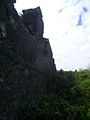 Much of the upper story structure remains intact


References
- v
- t
- e
British Virgin Islands articles
- Dutch Virgin Islands
- St. Phillip's Church
- Slavery
- Piracy
- Colonial leaders
- United States Virgin Islands
- British Leeward Islands
- West Indies Federation
- Effects of Hurricane Irma

- Anegada
- Beef Island
- Bellamy Cay
- Buck Island
- Carvel Rock
- Cockroach Island
- Cooper Island
- Dead Chest Island
- Diamond Cay
- Dog Islands
- East Seal Dog Island
- Eustatia
- Fallen Jerusalem Island
- Frenchman's Cay
- George Dog Island
- Ginger Island
- Great Camanoe
- Great Dog Island
- Great Thatch
- Great Tobago Island
- Green Cay
- Guana Island
- The Indians
- Jost Van Dyke
- Little Camanoe
- Little Cay
- Little Jost Van Dyke
- Little Thatch
- Little Tobago
- Little Wickams Cay
- Marina Cay
- Mosquito Island
- Nanny Cay
- Necker Island
- Norman Island
- Old Jerusalem Island
- Pelican Island
- Peter Island
- Prickly Pear
- Round Rock
- Saba Rock
- Salt Island
- Sandy Cay
- Sandy Spit
- Scrub Island
- Tortola
- Virgin Gorda
- West Dog Island
- Wickams Cay
|
- Cooper Bay ruin
- Cooten Bay ruin
- Copper Mine
- Fort Burt
- Fort Charlotte
- Fort George
- Fort Purcell ("the Dungeon")
- Fort Recovery
- Great Thatch ruin
- Hunthum's Ghut ruin
- Johnson's Ghut ruin
- Larmer Bay ruin
- Mount Healthy windmill
- Road Town Fort
- St Phillip's Church ("the African Church")
- Trunk Bay ruin
- Whelk Point Fort
- Terrance B. Lettsome International Airport
- Queen Elizabeth II Bridge
- Category
18°26′59″N 64°37′26″W / 18.4497°N 64.6239°W / 18.4497; -64.6239
 | This British Virgin Islands location article is a stub. You can help Wikipedia by expanding it. |
- v
- t
- e


