Ledyard Bridge
Bridge in New Hampshire and Norwich, Vermont
43°42′13″N 72°17′59″W / 43.70361°N 72.29972°W / 43.70361; -72.29972New Hampshire Route 10A,
Appalachian Trail

The Ledyard Bridge crosses the Connecticut River to connect Hanover, New Hampshire to Norwich, Vermont. It is the third bridge at this crossing to bear the name of the adventurer John Ledyard.
History
The first "Ledyard Free Bridge" was a covered bridge built in 1859 that was the first bridge across the Connecticut not to charge a toll. (It was the latest of several bridges at this site that went back to the late 18th century.) The bridge was named after Ledyard in 1859 because its eastern abutment was near the site of a tree that Ledyard felled during 1773 in order to make the dugout canoe in which he left Dartmouth College to continue his world travels.[2][citation needed]
The bridge now standing was built between 1998 and 2000 by the New Hampshire Department of Transportation.[3] At each end it displays a pair of "bridge balls," the controversial Classical ornaments cast in concrete that refer to the gateway to Tuck Drive nearby on the Hanover shore. They are the product of a Concord architect brought in by NHDOT to infuse some extra aesthetic appeal into the design of the bridge.[citation needed]
The Ledyard Bridge carries the designation of New Hampshire Route 10A and Vermont Route 10A, a short state highway linking U.S. Route 5 and Interstate 91 on the Vermont side with New Hampshire Route 10 on the New Hampshire side. The Appalachian Trail uses the pedestrian walkway to cross the river.
Border location
Although the border between New Hampshire and Vermont was set at the Vermont shore early in the states' histories, the bridge's monument to that border rests near the middle of the crossing; the reasoning is that the border was fixed before the Wilder Dam pushed the Vermont shore westward during the 1950s.[citation needed]
-
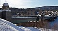
 Ledyard from Vermont
 -
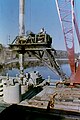 Bore shaft operations on Vermont side
 -
 Bore shaft operations
 -
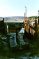 NH abutment footing
 -
 NH view of old and new Ledyard
 -
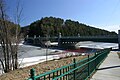
 Ledyard from New Hampshire


See also
References
- ^ "BRIDGES OF THE PAST - New Hampshire Covered Bridges". www.nh.gov.
- ^ Hard, Walter (1998) [1947]. Conuel, Thomas (series); Allen, Hervey; Carmer, Carl; Crawford, Jean (associate); Ball, Faith (art) (eds.). The Connecticut. The Rivers of America (2nd ed.). Lincoln, Massachusetts: Massachusetts Audubon Society. p. 154. ISBN 0-932691-27-7.
- ^ Associated Press (December 31, 1994), "N.H., Vermont end dispute over design of proposed bridge", The Boston Globe (Boston, MA)
Crossings of the Connecticut River | ||||
|---|---|---|---|---|
| ||||


- v
- t
- e
| Connecticut |
|
|---|---|
| Massachusetts |
|
| New Hampshire |
|
| Vermont |
|
- Amtrak Old Saybrook – Old Lyme Bridge
- Arch Bridge
- Bulkeley Bridge
- Calvin Coolidge Bridge
- Canalside Rail Trail Bridge
- Cheshire Bridge
- Columbia Bridge
- Cornish–Windsor Covered Bridge
- Dexter Coffin Bridge
- French King Bridge
- Gill–Montague Bridge
- Hampden County Memorial Bridge
- Janice Peaslee Bridge
- Joseph E. Muller Bridge
- Ledyard Bridge
- Lyme–East Thetford Bridge
- Morey Memorial Bridge
- Mount Orne Covered Bridge
- Norwottuck Rail Trail Bridge
- Piermont Bridge
- Pittsburg–Clarksville Covered Bridge
- Ranger Bridge
- Raymond E. Baldwin Bridge
- Sunderland Bridge
- Vietnam Memorial Bridge
- Wells River Bridge
- Willimansett Bridge


