List of Indiana state historical markers in Harrison County

This is a list of the Indiana state historical markers in Harrison County.
This is intended to be a complete list of the official state historical markers placed in Harrison County, Indiana, United States by the Indiana Historical Bureau. The locations of the historical markers and their latitude and longitude coordinates are included below when available, along with their names, years of placement, and topics as recorded by the Historical Bureau. There are 23 historical markers located in Harrison County.[1]
Map all coordinates using OpenStreetMap
Download coordinates as:
- KML
- GPX (all coordinates)
- GPX (primary coordinates)
- GPX (secondary coordinates)
Historical markers
| Marker title | Image | Year placed | Location | Topics |
|---|---|---|---|---|
| Indiana Capitol[2] |  | 1948 | N. Capitol Avenue adjacent to the Harrison County Courthouse in Corydon 38°12′43″N 86°7′34″W / 38.21194°N 86.12611°W / 38.21194; -86.12611 (Indiana Capitol) | Politics, Government Institutions, Buildings and Architecture |
| Battle of Corydon July 9, 1863[3] | 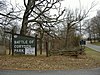 | 1961 | 300 N. Capitol on the southwestern corner of the Harrison County Courthouse lawn in Corydon 38°12′42.6″N 86°7′34″W / 38.211833°N 86.12611°W / 38.211833; -86.12611 (Battle of Corydon July 9, 1863) | Military |
| First State Office Building[4] |  | 1962 | Junction of Walnut and Mulberry Streets in Corydon 38°12′43.6″N 86°7′26.8″W / 38.212111°N 86.124111°W / 38.212111; -86.124111 (First State Office Building) | Government Institutions, Buildings and Architecture, Politics |
| First State Capital[5] |  | 1962 | State Road 62, 0.3 miles east of the State Road 135 junction between Dale and Williar Avenues, in western Corydon 38°12′41.4″N 86°7′34″W / 38.211500°N 86.12611°W / 38.211500; -86.12611 (First State Capital) | Politics, Government Institutions |
| Site of the Battle of Corydon July 9, 1863[6] |  | 1963 | Old State Road 135 at the Battle of Corydon Memorial Park entrance, 1 mile south of Corydon 38°12′0″N 86°7′49″W / 38.20000°N 86.13028°W / 38.20000; -86.13028 (Site of the Battle of Corydon July 9, 1863) | Military |
| Morgan's Raid July 8–13, 1863[7] | 1963 | Junction of State Roads 11 and 135, north of the Matthew E. Welsh Bridge over the Ohio River 38°1′24″N 86°11′39″W / 38.02333°N 86.19417°W / 38.02333; -86.19417 (Morgan's Raid July 8–13, 1863) | Military | |
| Posey House[8] |  | 1965 | 225 Oak Street in Corydon 38°12′41″N 86°7′39″W / 38.21139°N 86.12750°W / 38.21139; -86.12750 (Posey House) | Politics, Buildings and Architecture |
| Harrison County Jail[9] | 1965 | Southwestern corner of the junction of N. Capitol Avenue and Cherry Street in Corydon 38°12′42″N 86°7′35.4″W / 38.21167°N 86.126500°W / 38.21167; -86.126500 (Harrison County Jail) | Government Institutions, Buildings and Architecture | |
| Governor's Headquarters[10] |  | 1965 | Junction of E. Walnut and N. Elm Streets, northeast of the Harrison County Courthouse in Corydon 38°12′44.4″N 86°7′30.5″W / 38.212333°N 86.125139°W / 38.212333; -86.125139 (Governor's Headquarters) | Politics, Buildings and Architecture |
| Presbyterian Church[11] | 1965 | Junction of E. Walnut and N. Elm Streets, northeast of the Harrison County Courthouse in Corydon 38°12′44.4″N 86°7′31″W / 38.212333°N 86.12528°W / 38.212333; -86.12528 (Presbyterian Church) | Religion, Military | |
| Last Home of Squire Boone[12] | 1966 | Junction of State Roads 11 and 135, north of the Matthew E. Welsh Bridge over the Ohio River 38°1′24″N 86°11′38.4″W / 38.02333°N 86.194000°W / 38.02333; -86.194000 (Last Home of Squire Boone) | Early Settlement and Exploration | |
| Walter Q. Gresham[13] |  | 1966 | Junction of 2415 Barron Avenue and State Road 62 at the post office in Lanesville 38°14′16″N 85°59′11″W / 38.23778°N 85.98639°W / 38.23778; -85.98639 (Walter Q. Gresham) | Military, Politics |
| Mt. Solomon Lutheran Church[14] | 1966 | State Road 62, 5 miles west of Corydon 38°14′18″N 86°10′54″W / 38.23833°N 86.18167°W / 38.23833; -86.18167 (Mt. Solomon Lutheran Church) | Religion, Early Settlement and Exploration | |
| Cedar Hill Cemetery[15] | 1966 | Junction of E. Summit and N. Maple Streets in Corydon 38°12′52″N 86°7′19″W / 38.21444°N 86.12194°W / 38.21444; -86.12194 (Cedar Hill Cemetery) | Cemetery, Military | |
| Harrison County[16] |  | 1966 | Southeastern corner of the Harrison County Courthouse lawn at 300 N. Capitol in Corydon 38°12′42.5″N 86°7′32″W / 38.211806°N 86.12556°W / 38.211806; -86.12556 (Harrison County) | Early Settlement and Exploration |
| First State Capital[17] |  | 1978 | Northeastern corner of the Old Capitol Grounds along N. Elm Street in Corydon 38°12′42″N 86°7′32″W / 38.21167°N 86.12556°W / 38.21167; -86.12556 (First State Capital) | Politics, Government Institutions |
| Corydon United Methodist Church[18] |  | 1980 | 214 N. Elm Street, east of the courthouse, in Corydon 38°12′41″N 86°7′31″W / 38.21139°N 86.12528°W / 38.21139; -86.12528 (Corydon United Methodist Church) | Religion |
| Cedar Glade[19] |  | 1992 | 772 N. Capitol Avenue at the southeastern corner of the Indian Creek bridge in Corydon 38°13′5″N 86°7′33″W / 38.21806°N 86.12583°W / 38.21806; -86.12583 (Cedar Glade) | Buildings and Architecture, Nature and Natural Disasters |
| Leora Brown School[20] |  | 1995 | 400 E. Summit Street near the Hill Street junction in Corydon 38°12′51″N 86°7′16″W / 38.21417°N 86.12111°W / 38.21417; -86.12111 (Leora Brown School) | African American, Education |
| St. Paul African Methodist Episcopal Church[21] | 2003 | Southeastern corner of the junction of Maple and High Streets in Corydon 38°12′47.6″N 86°7′19″W / 38.213222°N 86.12194°W / 38.213222; -86.12194 (St. Paul African Methodist Episcopal Church) | Religion, African American | |
| John Shields, Lewis and Clark Expedition Member[22] | 2004 | 310 N. Elm Street at the Harrison County Convention and Visitors Bureau offices in Corydon 38°12′42.6″N 86°7′31″W / 38.211833°N 86.12528°W / 38.211833; -86.12528 (John Shields, Lewis and Clark Expedition Member) | Early Settlement and Exploration | |
| Oswell Wright[23] | 2008 | Near the junction of Maple and Chestnut Streets in Corydon 38°12′37.4″N 86°7′17″W / 38.210389°N 86.12139°W / 38.210389; -86.12139 (Oswell Wright) | [none] | |
| Polly Strong Slavery Case[24] | 2016 | 300 N. Capitol Ave., Corydon, between the Harrison County Courthouse and the First State Capitol building 38°12′42″N 86°07′33″W / 38.21167°N 86.12583°W / 38.21167; -86.12583 (Polly Strong Slavery Case) | African American, Law & Court Case, Women |
See also
- List of Indiana state historical markers
- National Register of Historic Places listings in Harrison County, Indiana
References
- ^ "Indiana Historical Markers by County". State of Indiana. Retrieved 2012-03-15.
- ^ Indiana Capitol, Indiana Historical Bureau, n.d. Accessed 2012-03-14.
- ^ Battle of Corydon July 9, 1863, Indiana Historical Bureau, n.d. Accessed 2012-03-14.
- ^ First State Office Building, Indiana Historical Bureau, n.d. Accessed 2012-03-14.
- ^ First State Capital, Indiana Historical Bureau, n.d. Accessed 2012-03-14.
- ^ Site of the Battle of Corydon July 9, 1863, Indiana Historical Bureau, n.d. Accessed 2012-03-14.
- ^ Morgan's Raid July 8-13, 1863, Indiana Historical Bureau, n.d. Accessed 2012-03-14.
- ^ Posey House, Indiana Historical Bureau, n.d. Accessed 2012-03-14.
- ^ Harrison County Jail, Indiana Historical Bureau, n.d. Accessed 2012-03-14.
- ^ Governor's Headquarters, Indiana Historical Bureau, n.d. Accessed 2012-03-14.
- ^ Presbyterian Church, Indiana Historical Bureau, n.d. Accessed 2012-03-14.
- ^ Last Home of Squire Boone, Indiana Historical Bureau, n.d. Accessed 2012-03-14.
- ^ Walter Q. Gresham, Indiana Historical Bureau, n.d. Accessed 2012-03-14.
- ^ Mt. Solomon Lutheran Church, Indiana Historical Bureau, n.d. Accessed 2012-03-14.
- ^ Cedar Hill Cemetery, Indiana Historical Bureau, n.d. Accessed 2012-03-14.
- ^ Harrison County, Indiana Historical Bureau, n.d. Accessed 2012-03-14.
- ^ First State Capital, Indiana Historical Bureau, n.d. Accessed 2012-03-14.
- ^ Corydon United Methodist Church, Indiana Historical Bureau, n.d. Accessed 2012-03-14.
- ^ Cedar Glade, Indiana Historical Bureau, n.d. Accessed 2012-03-14.
- ^ Leora Brown School, Indiana Historical Bureau, n.d. Accessed 2012-03-14.
- ^ St. Paul African Methodist Episcopal Church, Indiana Historical Bureau, n.d. Accessed 2012-03-14.
- ^ John Shields, Lewis and Clark Expedition Member, Indiana Historical Bureau, n.d. Accessed 2012-03-14.
- ^ Oswell Wright, Indiana Historical Bureau, n.d. Accessed 2012-03-14.
- ^ IHB (2020-12-15). "Polly Strong Slavery Case". IHB. Retrieved 2024-03-13.
External links
- Indiana Historical Marker Program
- Indiana Historical Bureau
- v
- t
- e
Municipalities and communities of Harrison County, Indiana, United States
County seat: Corydon

communities
‡This populated place also has portions in an adjacent county or counties
- Indiana portal
- United States portal


