List of listed buildings in Kelton, Dumfries and Galloway
This is a list of listed buildings in the parish of Kelton, Dumfries and Galloway, Scotland.
Map all coordinates using OpenStreetMap
Download coordinates as:
- KML
- GPX (all coordinates)
- GPX (primary coordinates)
- GPX (secondary coordinates)
List
| Name | Location | Date Listed | Grid Ref. [note 1] | Geo-coordinates | Notes | LB Number [note 2] | Image |
|---|---|---|---|---|---|---|---|
| Slatehole | 54°55′11″N 3°57′34″W / 54.91971°N 3.959517°W / 54.91971; -3.959517 (Slatehole) | Category B | 9827 |  Upload Photo | |||
| Billies Farmhouse | 54°53′39″N 3°59′25″W / 54.894185°N 3.990401°W / 54.894185; -3.990401 (Billies Farmhouse) | Category B | 9833 | Upload Photo | |||
| Douglas Mausoleum, Near To Kelton Parish Church, Railings And Gatepiers | 54°55′20″N 3°56′18″W / 54.922342°N 3.938266°W / 54.922342; -3.938266 (Douglas Mausoleum, Near To Kelton Parish Church, Railings And Gatepiers) | Category A | 9835 |  Upload another image | |||
| Gelston Castle Estate, Gelston Coach House And Gatepiers | 54°54′13″N 3°54′35″W / 54.903516°N 3.90969°W / 54.903516; -3.90969 (Gelston Castle Estate, Gelston Coach House And Gatepiers) | Category B | 9837 | Upload Photo | |||
| Kelton Old Church In Old Churchyard | 54°55′15″N 3°56′05″W / 54.920959°N 3.934829°W / 54.920959; -3.934829 (Kelton Old Church In Old Churchyard) | Category C(S) | 9821 | Upload Photo | |||
| Kelton Parish Church | 54°55′17″N 3°56′15″W / 54.92151°N 3.937492°W / 54.92151; -3.937492 (Kelton Parish Church) | Category B | 9822 | Upload Photo | |||
| Ingleston | 54°54′05″N 3°54′55″W / 54.901333°N 3.915296°W / 54.901333; -3.915296 (Ingleston) | Category B | 9817 | Upload Photo | |||
| Rhonehouse, Rodney House | 54°55′02″N 3°57′48″W / 54.917193°N 3.963436°W / 54.917193; -3.963436 (Rhonehouse, Rodney House) | Category C(S) | 9826 | Upload Photo | |||
| Threave Bridge | 54°55′18″N 3°58′18″W / 54.921671°N 3.971644°W / 54.921671; -3.971644 (Threave Bridge) | Category B | 9828 | Upload Photo | |||
| Kelton Mill, Byre | 54°55′17″N 3°57′32″W / 54.921373°N 3.958942°W / 54.921373; -3.958942 (Kelton Mill, Byre) | Category C(S) | 9820 | Upload Photo | |||
| Threave House | 54°55′22″N 3°56′51″W / 54.922897°N 3.947453°W / 54.922897; -3.947453 (Threave House) | Category B | 9829 | 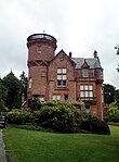 Upload another image | |||
| Threave Stables | 54°55′29″N 3°56′56″W / 54.924671°N 3.948896°W / 54.924671; -3.948896 (Threave Stables) | Category B | 9830 | Upload Photo | |||
| Dildawn House And Walled Garden | 54°54′43″N 3°59′13″W / 54.912056°N 3.986915°W / 54.912056; -3.986915 (Dildawn House And Walled Garden) | Category B | 9834 | Upload Photo | |||
| Old Bridge Of Dee | 54°55′06″N 3°58′34″W / 54.918226°N 3.976203°W / 54.918226; -3.976203 (Old Bridge Of Dee) | Category A | 9838 |  Upload another image | |||
| Kelton Mains Farm | 54°56′03″N 3°57′33″W / 54.93423°N 3.959224°W / 54.93423; -3.959224 (Kelton Mains Farm) | Category B | 9818 | Upload Photo | |||
| Airieland Farm House | 54°53′40″N 3°56′20″W / 54.894345°N 3.938792°W / 54.894345; -3.938792 (Airieland Farm House) | Category B | 9831 | Upload Photo | |||
| Gelston Castle | 54°54′17″N 3°54′31″W / 54.904791°N 3.908628°W / 54.904791; -3.908628 (Gelston Castle) | Category A | 9836 |  Upload another image | |||
| Gelston Castle Estate, Gelston Stables And Walled Gardens | 54°54′14″N 3°54′34″W / 54.903887°N 3.90949°W / 54.903887; -3.90949 (Gelston Castle Estate, Gelston Stables And Walled Gardens) | Category B | 9816 | 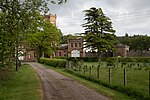 Upload another image | |||
| Kelton Mill | 54°55′18″N 3°57′31″W / 54.921737°N 3.958664°W / 54.921737; -3.958664 (Kelton Mill) | Category C(S) | 9819 | Upload Photo | |||
| Rhonehouse, Creaghlas | 54°55′03″N 3°57′46″W / 54.917454°N 3.96284°W / 54.917454; -3.96284 (Rhonehouse, Creaghlas) | Category C(S) | 9824 | Upload Photo | |||
| Rhonehouse Of Kelton, Millhill | 54°55′03″N 3°57′44″W / 54.91742°N 3.962167°W / 54.91742; -3.962167 (Rhonehouse Of Kelton, Millhill) | Category B | 9825 | Upload Photo | |||
| Rhonehouse, An Teallach | 54°55′00″N 3°57′49″W / 54.916786°N 3.963572°W / 54.916786; -3.963572 (Rhonehouse, An Teallach) | Category C(S) | 9823 | Upload Photo | |||
| Airieland House | 54°53′42″N 3°56′14″W / 54.895°N 3.937201°W / 54.895; -3.937201 (Airieland House) | Category B | 9832 | Upload Photo |
Key
The scheme for classifying buildings in Scotland is:
- Category A: "buildings of national or international importance, either architectural or historic; or fine, little-altered examples of some particular period, style or building type."[1]
- Category B: "buildings of regional or more than local importance; or major examples of some particular period, style or building type, which may have been altered."[1]
- Category C: "buildings of local importance; lesser examples of any period, style, or building type, as originally constructed or moderately altered; and simple traditional buildings which group well with other listed buildings."[1]
In March 2016 there were 47,288 listed buildings in Scotland. Of these, 8% were Category A, and 50% were Category B, with the remaining 42% being Category C.[2]
Notes
- ^ Sometimes known as OSGB36, the grid reference (where provided) is based on the British national grid reference system used by the Ordnance Survey.
• "Guide to National Grid". Ordnance Survey. Retrieved 12 December 2007.
• "Get-a-map". Ordnance Survey. Retrieved 17 December 2007. - ^ Historic Environment Scotland assign a unique alphanumeric identifier to each designated site in Scotland, for listed buildings this always begins with "LB", for example "LB12345".
References
- All entries, addresses and coordinates are based on data from Historic Scotland. This data falls under the Open Government Licence
- ^ a b c "What is Listing?". Historic Environment Scotland. Retrieved 29 May 2018.
- ^ Scotland's Historic Environment Audit 2016 (PDF). Historic Environment Scotland and the Built Environment Forum Scotland. pp. 15–16. Retrieved 29 May 2018.
- v
- t
- e
- Annan
- Applegarth
- Caerlaverock
- Canonbie
- Closeburn
- Cummertrees
- Dalton
- Dornock
- Dryfesdale
- Dumfries
- Dunscore
- Durisdeer
- Eskdalemuir
- Ewes
- Glencairn
- Gretna
- Half Morton
- Hoddom
- Holywood
- Hutton and Corrie
- Johnstone
- Keir
- Kirkconnel
- Kirkmahoe
- Kirkmichael
- Kirkpatrick-Fleming
- Kirkpatrick-Juxta
- Langholm
- Lochmaben
- Lockerbie
- Middlebie
- Moffat
- Morton
- Mouswald
- Penpont
- Ruthwell
- Sanquhar
- St Mungo
- Tinwald
- Torthorwald
- Tundergarth
- Tynron
- Wamphray
- Westerkirk
- Anwoth
- Balmaclellan
- Balmaghie
- Borgue
- Buittle
- Carsphairn
- Castle Douglas
- Colvend and Southwick
- Crossmichael
- Dalbeattie
- Dalry
- Gatehouse of Fleet
- Girthon
- Kells
- Kelton
- Kirkbean
- Kirkcudbright
- Kirkgunzeon
- Kirkmabreck
- Kirkpatrick Durham
- Kirkpatrick Irongray
- Lochrutton
- Minnigaff
- New Abbey
- New Galloway
- Newton Stewart
- Parton
- Rerrick
- Terregles
- Tongland
- Troqueer
- Twynholm
- Urr


