Maintirano District
District in Melaky, Madagascar
16°9′S 46°37′E / 16.150°S 46.617°E / -16.150; 46.617 Madagascar
 (2020 estimate)
413
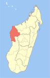
Maintirano is a district in western Madagascar. It is a part of Melaky Region and borders the districts of Besalampy in north, Morafenobe in east and Antsalova in south. The area is 10,031 km2 (3,873 sq mi) and the population was estimated to be 122,505 in 2020.[1][2]
Communes
The district is further divided into 14 communes:
- Andabotoka
- Andranovao
- Andrea, Melaky
- Ankisatra
- Antsahidoha Bebao
- Antsondrodava
- Bebakony Sud
- Belitsaky
- Berevo-Ranobe
- Betanatanana
- Mafaijijo
- Maintirano
- Marohazo
- Maromavo
- Tambohorano
- Veromanga
Infrastructures
Maintirano is served by Maintirano Airport and a local maritime harbour. The town has a permanent court and hospital.
Roads
- The hardly practicable Nationale Road 1a connects the city with Tsiroanomandidy and inlands.
- The Nationale Road 8a leads southwards to Antsalova.
- The Nationale Road 19 northwards to Mahajunga.
Nature reserves
The karstic tsingys of the Beanka Reserve is situated at Ambinda (Andrea) and Belitsaky.
References
- ^ a b "Madagascar Administrative units". GeoHive. Archived from the original on 2009-04-23. Retrieved 2008-03-04.
- ^ "Maintirano (District, Madagascar) - Population Statistics, Charts, Map and Location". www.citypopulation.de. Retrieved 2024-01-17.
16°9′S 46°37′E / 16.150°S 46.617°E / -16.150; 46.617
- v
- t
- e
Capital: Maintirano
- Ambolodia Sud
- Ampako
- Ankasakasa Tsibiray
- Antsirasira
- Bekodoka
- Besalampy
- Mahabe
- Marovoay Sud
- Soanenga
5 districts; 40 communes
Authority control databases | |
|---|---|
| International |
|
| Other |
|
 | This Melaky location article is a stub. You can help Wikipedia by expanding it. |
- v
- t
- e


