Maysville, West Virginia
Unincorporated community in West Virginia, United States
39°6′54″N 79°9′53″W / 39.11500°N 79.16472°W / 39.11500; -79.1647226833[1]
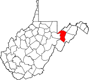
The original county seat of Grant County, Maysville is an unincorporated community on North Fork Lunice Creek in Grant County, West Virginia, United States. The community lies at the eastern approach of Mays Gap in Knobly Mountain along West Virginia Route 42.
The community's name is derived from the local Mays or Mayse family.[3]
References
- ^ "Maysville ZIP Code". zipdatamaps.com. 2022. Retrieved November 11, 2022.
- ^ U.S. Geological Survey Geographic Names Information System: Maysville, West Virginia
- ^ Kenny, Hamill (1945). West Virginia Place Names: Their Origin and Meaning, Including the Nomenclature of the Streams and Mountains. Piedmont, WV: The Place Name Press. p. 407.
- v
- t
- e
Municipalities and communities of Grant County, West Virginia, United States
County seat: Petersburg
communities
‡This populated place also has portions in an adjacent county or counties
- West Virginia portal
- United States portal
Wikimedia Commons has media related to Maysville, West Virginia.
 | This article about a location in Grant County, West Virginia is a stub. You can help Wikipedia by expanding it. |
- v
- t
- e


