Milower Land
Municipality in Brandenburg, Germany
Municipality in Brandenburg, Germany

Coat of arms
Location of Milower Land within Havelland district

(2022-12-31)[2]
14715
033873, 033877
Milower Land (German pronunciation: [ˈmiːloːɐ̯ ˈlant]) is a municipality in the Havelland district, in Brandenburg, Germany.
Demography
-
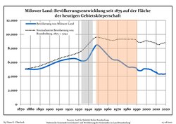 Development of Population since 1875 within the Current Boundaries (Blue Line: Population; Dotted Line: Comparison to Population Development of Brandenburg state; Grey Background: Time of Nazi rule; Red Background: Time of Communist rule)
 -
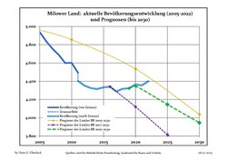 Recent Population Development and Projections (Population Development before Census 2011 (blue line); Recent Population Development according to the Census in Germany in 2011 (blue bordered line); Official projections for 2005-2030 (yellow line); for 2017-2030 (scarlet line); for 2020-2030 (green line)


|
|
|
References
- ^ Landkreis Havelland Wahl der Bürgermeisterin / des Bürgermeisters, accessed 1 July 2021.
- ^ "Bevölkerungsentwicklung und Bevölkerungsstandim Land Brandenburg Dezember 2022" (PDF). Amt für Statistik Berlin-Brandenburg (in German). June 2023.
- ^ Detailed data sources are to be found in the Wikimedia Commons.Population Projection Brandenburg at Wikimedia Commons
- v
- t
- e
Towns and municipalities in Havelland
- Brieselang
- Dallgow-Döberitz
- Falkensee
- Friesack
- Gollenberg
- Großderschau
- Havelaue
- Ketzin
- Kleßen-Görne
- Kotzen
- Märkisch Luch
- Milower Land
- Mühlenberge
- Nauen
- Nennhausen
- Paulinenaue
- Pessin
- Premnitz
- Rathenow
- Retzow
- Rhinow
- Schönwalde-Glien
- Seeblick
- Stechow-Ferchesar
- Wiesenaue
- Wustermark

Authority control databases | |
|---|---|
| International |
|
| National |
|
 | This Brandenburg location article is a stub. You can help Wikipedia by expanding it. |
- v
- t
- e


