Monte Cristi National Park
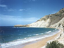
Monte Cristi National Park (Parque National Monte Cristi) is a national park on the Caribbean Island of Hispaniola that extends from the borders of Haiti to Punta Rucia in the Dominican Republic and covers an area of 550 km2. It contains coastal lagoons, beaches, mangrove swamps, a 237 m (777 ft) limestone mesa from which can be seen offshore keys and forested slopes of the mesa's northern side.[1]
The area is very dry, receiving just over two inches of rain per year. The huge mesa provides a habitat for an indigenous plant species called sabia montecristini as well as several reptile species. There are no marked paths in the park.[2]
See also
Footnotes
External links
- Monte Cristi Shipwreck Project - The 2001 Excavation
- The Rhenish Stoneware from the Monte Cristi Shipwreck, Dominican Republic
Wikimedia Commons has media related to Monte Cristi National Park.
- v
- t
- e
• Cueva de las Maravillas National Park
• El Choco National Park • Isabel De Torres National Park • Isla Cabritos National Park • Jaragua National Park • José Armando Bermúdez National Park • José del Carmen Ramírez National Park • La Caleta Underwater National Park • Los Haitises National Park • Monte Cristi National Park • Parque Nacional Del Este • Perez Rancier National Park • Pueblo Viejo National Park • Sierra De Baoruco National Park
• Valle Nuevo National Park
19°46′37″N 71°42′08″W / 19.777042°N 71.702271°W / 19.777042; -71.702271
 | This Dominican Republic location article is a stub. You can help Wikipedia by expanding it. |
- v
- t
- e


