Mount Faber


Mount Faber
Location in Singapore
Place in Singapore
Mount Faber | |
|---|---|
| Name transcription(s) | |
| • Chinese | 花柏山 |
| • Pinyin | Hūa bǎi shān |
| • Malay | Bukit Faber |
| • Tamil | பேபர் மலை |
| Country | Singapore |
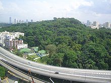
Mount Faber, formerly Telok Blangah Hill, is a hill about 94 metres (308 ft) in height, located in the town of Bukit Merah in the Central Region of Singapore. It overlooks the Telok Blangah area and the western parts of the Central Area. The summit is accessible by Mount Faber Road[1] or Mount Faber Loop via Morse Road, but there are many footpaths or trails leading up the hill. The main paths are: Marang Trail, which leads from Marang Road at the Harbourfront MRT station (Exit D), and the Southern Ridges Park Connector which connects from Telok Blangah Hill Park, Kent Ridge Park, and Henderson Waves.
It is a major tourist attraction, as it provides a panoramic view of the dense central business district within the Central Area.[2] Its slope includes a tower that is part of the Singapore cable car system that connects to HarbourFront and Sentosa.[3] It is accessible from the HarbourFront MRT station.
History
Mount Faber was known as Telok Blangah Hill but was later renamed after Captain Charles Edward Faber of the Madras Engineers, the superintending engineer in the Straits and Governor Butterworth's brother-in-law, who arrived in Singapore in September 1844. Faber cut through the thick undergrowth, allowing the road to the top of the hill to be built. The original winding road was referred to in the press at that time as a "stupidly narrow road".
The article also questioned the change of the name from what it deemed its originally more appropriate Malay name. A signal station was erected on the hill in 1845. This signal station was transferred from Pulau Blakang Mati (now Sentosa) because of the "injurious miasma" on the island.
After the Indian Mutiny of 1857, the Straits government decided to convert Mount Faber into a fort for fear of revolt among the local Indian sepoys. Defence work was carried out and granite emplacements for guns were completed halfway up the hill, but Mount Faber never became a fort.
In 1972, the government spent S$63,910 to renovate the bunkers and turn Mount Faber into a landscaped scenic spot.[4] Construction on the S$2.94 million cable car system to link Mount Faber and Sentosa together also began.[5][3][6]
Geography
The vegetation around Mount Faber is a secondary rainforest that is smaller and less dense than on Bukit Timah Hill. Mount Faber is one of the higher hills in Singapore at 106 metres (348 ft),[7] lower than Bukit Timah Hill (164 m (538 ft)) and Bukit Gombak (133 m (436 ft)) and 113 m (371 ft)). It is separated from the adjacent slightly lower Telok Blangah Hill Park by Henderson Road.
Gallery
-
![The Jewel Box on Mount Faber houses the cable car station to Sentosa.[8]](//upload.wikimedia.org/wikipedia/commons/thumb/f/fe/The_Jewel_Box%2C_Nov_06.JPG/120px-The_Jewel_Box%2C_Nov_06.JPG)
-
 Panoramic view of HarbourFront from Mount Faber Park
 -
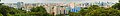 Panoramic view from Mount Faber, September 2008.
![The Jewel Box on Mount Faber houses the cable car station to Sentosa.[8]](http://upload.wikimedia.org/wikipedia/commons/thumb/f/fe/The_Jewel_Box%2C_Nov_06.JPG/120px-The_Jewel_Box%2C_Nov_06.JPG)


See also
References
Citations
- ^ "Mount Faber Rd closed". The Straits Times. 5 June 1983. p. 15. Retrieved 5 January 2024 – via NewspaperSG.
- ^ Mohamed, Sulaiman (12 April 1972). "Untidy roads at Mt. Faber". New Nation. p. 6. Retrieved 5 January 2024 – via NewspaperSG.
- ^ a b "Copter used to instal cable car system". The Straits Times. 15 February 1974. p. 11. Retrieved 5 January 2024 – via NewspaperSG.
- ^ "Govt. to spend $64,000 more on Mt. Faber". New Nation. 12 September 1972. p. 7. Retrieved 5 January 2024 – via NewspaperSG.
- ^ "A scenic lookout post for tourists at Mt Faber". The Straits Times. 19 February 1978. p. 7. Retrieved 5 January 2024 – via NewspaperSG.
- ^ Poteik, Chia (14 August 1971). "$2.9 m cable car contract". The Straits Times. p. 19. Retrieved 5 January 2024 – via NewspaperSG.
- ^ "MAST-HIGH VIEWPOINT OVER THE COLONY". The Straits Times. 1 May 1953. p. 12. Retrieved 5 January 2024 – via NewspaperSG.
- ^ Tan, Hui Leng (9 June 2005). "Mount Faber's new jewel box". Today. p. 8. Retrieved 5 January 2024 – via NewspaperSG.
Bibliography
- Victor R Savage, Brenda S A Yeoh (2003), Tan Le Ci(2007)Toponymics - A Study of Singapore Street Names, Eastern Universities Press, ISBN 981-210-205-1
External links
Wikimedia Commons has media related to Mount Faber.
- National Parks Board, Singapore
- Mount Faber (history), streetdirectory.com Singapore Guide
- v
- t
- e
Places in Singapore by region
Listed by planning areas (Subzones in parentheses)
- Central Area (City centre)
- Bishan
- Bukit Merah
- Alexandra Hill
- Alexandra North
- Bukit Ho Swee
- Bukit Merah
- Depot Road
- Everton Park
- HarbourFront/Maritime Square
- Henderson Hill
- Kampong Tiong Bahru
- Redhill
- Singapore General Hospital
- Telok Blangah Drive
- Telok Blangah Rise
- Telok Blangah Way
- Tiong Bahru
- Bukit Timah
- Anak Bukit
- Coronation Road
- Farrer Court
- Hillcrest
- Holland Road
- Leedon Park
- Swiss Club
- Ulu Pandan
- Downtown Core
- Anson
- Bayfront Subzone
- Bugis
- Cecil
- Central Subzone
- City Hall
- Clifford Pier
- Marina Centre
- Maxwell
- Millenia Singapore
- Nicoll
- Phillip
- Raffles Place
- Tanjong Pagar
- Geylang
- Aljunied
- Geylang East
- Kallang Way
- Kampong Ubi
- MacPherson
- Kallang
- Marina East
- Marina South
- Marine Parade
- East Coast
- Katong
- Marina East
- Marine Parade
- Mountbatten
- Museum
- Newton
- Cairnhill
- Goodwood Park
- Istana Negara
- Monk's Hill
- Newton Circus
- Orange Grove
- Novena
- Balestier
- Dunearn
- Malcolm
- Moulmein
- Mount Pleasant
- Orchard
- Boulevard
- Somerset
- Tanglin
- Outram
- China Square
- Chinatown
- Pearl's Hill
- People's Park
- Queenstown
- Commonwealth
- Dover
- Ghim Moh
- Kent Ridge
- Margaret Drive
- Mei Chin
- National University of Singapore
- one-north
- Pasir Panjang 1
- Pasir Panjang 2
- Tanglin Halt
- Queensway
- River Valley
- Institution Hill
- Leonie Hill
- One Tree Hill
- Oxley
- Paterson
- Rochor
- Bencoolen
- Farrer Park
- Kampong Glam
- Little India
- Mackenzie
- Mount Emily
- Rochor Canal
- Selegie
- Sungei Road
- Victoria
- Singapore River
- Southern Islands
- Straits View
- Tanglin
- Chatsworth
- Nassim
- Ridout
- Tyersall
- Toa Payoh
- Bidadari
- Boon Teck
- Braddell
- Joo Seng
- Kim Keat
- Lorong 8 Toa Payoh
- Pei Chun
- Potong Pasir
- Sennett
- Toa Payoh Central
- Toa Payoh West
- Woodleigh
- Bedok
- Bayshore
- Bedok North
- Reservoir
- Bedok South
- Frankel
- Kaki Bukit
- Kembangan
- Siglap
- Changi
- Airport
- Changi Point
- Changi West
- Changi Bay
- Pasir Ris
- Flora Drive
- Loyang East
- Loyang West
- Pasir Ris Central
- Pasir Ris Drive
- Pasir Ris Park
- Pasir Ris Wafer Fab Park
- Pasir Ris West
- Paya Lebar
- Airport Road, Singapore
- Paya Lebar East
- Paya Lebar North
- Paya Lebar West
- Plab
- Tampines
- Central Water Catchment
- Lim Chu Kang
- Mandai
- Mandai East
- Mandai Estate
- Mandai West
- Sembawang
- Admiralty
- Sembawang Central
- Sembawang East
- Sembawang North
- Sembawang Spring
- Sembawang Straits
- Senoko North
- Senoko South
- The Wharves
- Simpang
- Pulau Seletar
- Simpang North
- Simpang South
- Tanjong Irau
- Sungei Kadut
- Woodlands
- Greenwood Park
- Midview
- North Coast
- Senoko West
- Woodgrove
- Woodlands East
- Woodlands Regional Centre
- Woodlands South
- Woodlands West
- Yishun
- Khatib
- Lower Seletar
- Nee Soon
- Northland
- Springleaf
- Yishun Central
- Yishun East
- Yishun South
- Yishun West
- Ang Mo Kio
- Ang Mo Kio Town Centre
- Cheng San
- Chong Boon
- Kebun Baru
- Sembawang Hills
- Shangri-la
- Tagore
- Townsville, Singapore
- Yio Chu Kang
- Yio Chu Kang East
- Yio Chu Kang North
- Yio Chu Kang West
- Hougang
- Defu Industrial Park
- Hougang Central
- Hougang East
- Hougang West
- Kangkar
- Kovan
- Lorong Ah Soo
- Lorong Halus
- Tai Seng
- Trafalgar
- North-Eastern Islands
- Punggol
- Coney Island
- Matilda
- Northshore
- Punggol Canal
- Punggol Field
- Punggol Town Centre
- Waterway East
- Seletar
- Pulau Punggol Barat
- Pulau Punggol Timor
- Seletar
- Aerospace Park
- Sengkang
- Anchorvale
- Compassvale
- Fernvale
- Jalan Kayu
- Lorong Halus North
- Rivervale
- Sengkang Town Centre
- Sengkang West
- Serangoon
- Lorong Chuan
- Seletar Hills
- Serangoon Central
- Serangoon Garden
- Serangoon North
- Serangoon North Industrial Estate
- Upper Paya Lebar
- Boon Lay
- Bukit Batok
- Bukit Panjang
- Bangkit
- Dairy Farm
- Fajar
- Jelebu
- Nature Reserve
- Saujana
- Senja
- Choa Chu Kang
- Clementi
- Clementi Central
- Clementi North
- Clementi West
- Clementi Woods
- Faber
- Pandan
- Sunset Way
- Toh Tuck
- West Coast
- Jurong East
- Jurong West
- Pioneer
- Benoi Sector
- Gul Basin
- Gul Circle
- Joo Koon
- Pioneer Sector
- Tengah
- Tuas
- Tengeh
- Tuas Bay
- Tuas North
- Tuas Promenade
- Tuas View
- Tuas View Extension
- Western Islands
- Western Water Catchment
| Authority control databases |
|
|---|


