National Register of Historic Places listings in Hampton County, South Carolina

This is a list of the National Register of Historic Places listings in Hampton County, South Carolina.
This is intended to be a complete list of the properties on the National Register of Historic Places in Hampton County, South Carolina, United States. The locations of National Register properties for which the latitude and longitude coordinates are included below, may be seen in a map.[1]
There are 15 properties listed on the National Register in the county.
This National Park Service list is complete through NPS recent listings posted June 14, 2024.[2]
Map all coordinates using OpenStreetMap
Download coordinates as:
- KML
- GPX (all coordinates)
- GPX (primary coordinates)
- GPX (secondary coordinates)
Current listings
| [3] | Name on the Register[4] | Image | Date listed[5] | Location | City or town | Description |
|---|---|---|---|---|---|---|
| 1 | American Legion Hut |  | October 27, 2000 (#00001235) | Junction of Hoover St. and Jackson Ave. 32°52′19″N 81°07′03″W / 32.871944°N 81.1175°W / 32.871944; -81.1175 (American Legion Hut) | Hampton | |
| 2 | Bank of Hampton |  | May 30, 2001 (#01000606) | 15 Elm St., E. 32°51′59″N 81°06′31″W / 32.866389°N 81.108611°W / 32.866389; -81.108611 (Bank of Hampton) | Hampton | |
| 3 | Cohasset |  | July 24, 1986 (#86001935) | U.S. Route 601 32°55′58″N 81°04′37″W / 32.93269°N 81.07694°W / 32.93269; -81.07694 (Cohasset) | Crocketville | On provat property, gated |
| 4 | Gifford Rosenwald School | 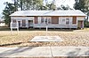 | October 4, 2017 (#100001720) | 6146 Columbia Hwy. 32°51′50″N 81°14′17″W / 32.863991°N 81.237936°W / 32.863991; -81.237936 (Gifford Rosenwald School) | Gifford | |
| 5 | Gravel Hill Plantation | Upload image | May 10, 2010 (#10000240) | 3954 Augusta Stage Coach Rd 32°58′00″N 81°23′09″W / 32.96669°N 81.38593°W / 32.96669; -81.38593 (Gravel Hill Plantation) | Garnett | |
| 6 | Hampton Colored School |  | February 28, 1991 (#91000233) | W. Holly St. east of its junction with Hoover St. 32°52′04″N 81°07′15″W / 32.867778°N 81.120833°W / 32.867778; -81.120833 (Hampton Colored School) | Hampton | |
| 7 | Hampton County Courthouse | 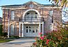 | December 12, 1978 (#78002517) | U.S. Route 278 32°51′58″N 81°06′34″W / 32.86616°N 81.10932°W / 32.86616; -81.10932 (Hampton County Courthouse) | Hampton | |
| 8 | Hampton County Jail | 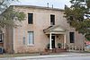 | June 23, 2011 (#11000405) | 702 1st St., W. 32°51′55″N 81°06′40″W / 32.8653993°N 81.1112201°W / 32.8653993; -81.1112201 (Hampton County Jail) | Hampton | Now the Hampton County Historical Society Museum |
| 9 | John Lawton House |  | July 1, 2009 (#09000484) | 118 3rd. St. on NRHP, now numbered 316 32°45′14″N 81°14′22″W / 32.753878°N 81.239325°W / 32.753878; -81.239325 (John Lawton House) | Estill | |
| 10 | Lawtonville Baptist Church |  | October 9, 2012 (#12000848) | 194 E. 4th St 32°45′18″N 81°14′18″W / 32.7549°N 81.23826°W / 32.7549; -81.23826 (Lawtonville Baptist Church) | Estill | |
| 11 | Oak Grove |  | July 12, 1976 (#76001704) | Southwest of Brunson 32°54′49″N 81°12′58″W / 32.91357°N 81.216°W / 32.91357; -81.216 (Oak Grove) | Brunson | |
| 12 | Palmetto Theatre |  | October 9, 2012 (#12000849) | 109 Lee Ave. 32°52′06″N 81°06′25″W / 32.86825°N 81.10694°W / 32.86825; -81.10694 (Palmetto Theatre) | Hampton | |
| 13 | Hattie J. Peeples House |  | October 13, 1992 (#92001299) | 109 Carolina Ave., W. 32°51′02″N 81°04′53″W / 32.85063°N 81.08131°W / 32.85063; -81.08131 (Hattie J. Peeples House) | Varnville | |
| 14 | The Pineland |  | July 8, 1999 (#99000814) | The Pineland Lane, off U.S. Route 321 32°36′55″N 81°14′28″W / 32.61536°N 81.24114°W / 32.61536; -81.24114 (The Pineland) | Garnett | |
| 15 | Stoney Creek Independent Presbyterian Chapel of Prince William Parish |  | May 22, 2002 (#02000559) | McPhersonville 32°41′31″N 80°54′53″W / 32.69207°N 80.91472°W / 32.69207; -80.91472 (Stoney Creek Independent Presbyterian Chapel of Prince William Parish) | McPhersonville | Also called the McPhersonville Church |
See also
Wikimedia Commons has media related to National Register of Historic Places in Hampton County, South Carolina.
- List of National Historic Landmarks in South Carolina
- National Register of Historic Places listings in South Carolina
References
- ^ The latitude and longitude information provided in this table was derived originally from the National Register Information System, which has been found to be fairly accurate for about 99% of listings. Some locations in this table may have been corrected to current GPS standards.
- ^ National Park Service, United States Department of the Interior, "National Register of Historic Places: Weekly List Actions", retrieved June 14, 2024.
- ^ Numbers represent an alphabetical ordering by significant words. Various colorings, defined here, differentiate National Historic Landmarks and historic districts from other NRHP buildings, structures, sites or objects.
- ^ "National Register Information System". National Register of Historic Places. National Park Service. March 13, 2009.
- ^ The eight-digit number below each date is the number assigned to each location in the National Register Information System database, which can be viewed by clicking the number.
- v
- t
- e

by county
- Abbeville
- Aiken
- Allendale
- Anderson
- Bamberg
- Barnwell
- Beaufort
- Berkeley
- Calhoun
- Charleston
- Cherokee
- Chester
- Chesterfield
- Clarendon
- Colleton
- Darlington
- Dillon
- Dorchester
- Edgefield
- Fairfield
- Florence
- Georgetown
- Greenville
- Greenwood
- Hampton
- Horry
- Jasper
- Kershaw
- Lancaster
- Laurens
- Lee
- Lexington
- Marion
- Marlboro
- McCormick
- Newberry
- Oconee
- Orangeburg
- Pickens
- Richland
- Saluda
- Spartanburg
- Sumter
- Union
- Williamsburg
- York
Municipalities and communities of Hampton County, South Carolina, United States | ||
|---|---|---|
County seat: Hampton | ||
| Towns |  | |
| Unincorporated communities | ||
| Footnotes | ‡This populated place also has portions in an adjacent county or counties | |
| ||


