National Register of Historic Places listings in Lemhi County, Idaho

This is a list of the National Register of Historic Places listings in Lemhi County, Idaho.
This is intended to be a complete list of the properties and districts on the National Register of Historic Places in Lemhi County, Idaho, United States. Latitude and longitude coordinates are provided for many National Register properties and districts; these locations may be seen together in a map.[1]
There are 15 properties and districts listed on the National Register in the county, including 1 National Historic Landmark. More may be added; properties and districts nationwide are added to the Register weekly.[2]
This National Park Service list is complete through NPS recent listings posted June 7, 2024.[3]
Map all coordinates using OpenStreetMap
Download coordinates as:
- KML
- GPX (all coordinates)
- GPX (primary coordinates)
- GPX (secondary coordinates)
Current listings
| [4] | Name on the Register[5] | Image | Date listed[6] | Location | City or town | Description |
|---|---|---|---|---|---|---|
| 1 | Charcoal Kilns |  | February 23, 1972 (#72001577) | Off State Highway 28 44°18′40″N 113°10′44″W / 44.311111°N 113.178889°W / 44.311111; -113.178889 (Charcoal Kilns) | Leadore | |
| 2 | Episcopal Church of the Redeemer | 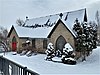 | January 12, 1979 (#79000801) | 1st, N. and Fulton Sts. 45°10′44″N 113°54′02″W / 45.178889°N 113.900556°W / 45.178889; -113.900556 (Episcopal Church of the Redeemer) | Salmon | |
| 3 | First Flag Unfurling Site, Lewis and Clark Trail | Upload image | August 22, 1975 (#75000635) | 5 miles north of Tendoy in the Bitterroot Mountains 45°01′21″N 113°34′27″W / 45.0225°N 113.574167°W / 45.0225; -113.574167 (First Flag Unfurling Site, Lewis and Clark Trail) | Tendoy | |
| 4 | Fort Lemhi |  | February 23, 1972 (#72000443) | Address Restricted[7] | Tendoy | |
| 5 | Lars Geertson House |  | April 3, 1980 (#80001330) | Southeast of Salmon 45°07′44″N 113°46′42″W / 45.128889°N 113.778333°W / 45.128889; -113.778333 (Lars Geertson House) | Salmon | |
| 6 | Leesburg |  | April 4, 1975 (#75000634) | West of Salmon at Napias Creek in the Salmon National Forest 45°13′32″N 114°06′44″W / 45.225556°N 114.112222°W / 45.225556; -114.112222 (Leesburg) | Salmon | |
| 7 | Lemhi Boarding School Girls Dormitory | Upload image | November 12, 1998 (#98001350) | Hayden Creek Rd., 1/8 mile southeast of its junction with U.S. Route 93 44°51′43″N 113°37′48″W / 44.861944°N 113.63°W / 44.861944; -113.63 (Lemhi Boarding School Girls Dormitory) | Lemhi | |
| 8 | Lemhi County Courthouse |  | February 7, 1978 (#78001078) | 206 Courthouse Dr. 45°10′45″N 113°54′08″W / 45.1792°N 113.9023°W / 45.1792; -113.9023 (Lemhi County Courthouse) | Salmon | |
| 9 | Lemhi Pass | 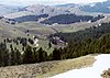 | October 15, 1966 (#66000313) | 12 miles east of Tendoy off State Highway 28, in the Beaverhead and Salmon National Forests 44°58′04″N 113°27′23″W / 44.967778°N 113.456389°W / 44.967778; -113.456389 (Lemhi Pass) | Tendoy | |
| 10 | Socrates A. Myers House |  | December 2, 1977 (#77000468) | 300 Hall St. 45°10′44″N 113°53′37″W / 45.178889°N 113.893611°W / 45.178889; -113.893611 (Socrates A. Myers House) | Salmon | |
| 11 | Odd Fellows Hall | 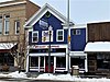 | February 7, 1978 (#78001079) | 516 Main St. 45°10′32″N 113°53′32″W / 45.175556°N 113.892222°W / 45.175556; -113.892222 (Odd Fellows Hall) | Salmon | |
| 12 | Salmon City Hall and Library |  | November 17, 1982 (#82000352) | 200 Main St. 45°10′32″N 113°53′32″W / 45.175556°N 113.892222°W / 45.175556; -113.892222 (Salmon City Hall and Library) | Salmon | |
| 13 | Salmon Odd Fellows Hall |  | August 25, 1978 (#78001080) | 510-514 Main St. 45°10′32″N 113°53′32″W / 45.175556°N 113.892222°W / 45.175556; -113.892222 (Salmon Odd Fellows Hall) | Salmon | |
| 14 | Shoup Building |  | March 31, 1978 (#78001081) | Center and Main Sts. 45°10′30″N 113°53′33″W / 45.175°N 113.8925°W / 45.175; -113.8925 (Shoup Building) | Salmon | |
| 15 | Shoup Rock Shelters | | November 8, 1974 (#74000744) | Address Restricted[7] | Cobalt |
See also
Wikimedia Commons has media related to National Register of Historic Places in Lemhi County, Idaho.
References
- ^ The latitude and longitude information provided in this table was derived originally from the National Register Information System, which has been found to be fairly accurate for about 99% of listings. Some locations in this table may have been corrected to current GPS standards.
- ^ "National Register of Historic Places: Weekly List Actions". National Park Service. Retrieved March 29, 2009.
- ^ National Park Service, United States Department of the Interior, "National Register of Historic Places: Weekly List Actions", retrieved June 7, 2024.
- ^ Numbers represent an alphabetical ordering by significant words. Various colorings, defined here, differentiate National Historic Landmarks and historic districts from other NRHP buildings, structures, sites or objects.
- ^ "National Register Information System". National Register of Historic Places. National Park Service. April 24, 2008.
- ^ The eight-digit number below each date is the number assigned to each location in the National Register Information System database, which can be viewed by clicking the number.
- ^ a b Some listings on the NRHP are highly sensitive sites and may be subject to looting or vandalism. The NRHP lists this site as "Address Restricted."
- v
- t
- e
- Ada
- Adams
- Bannock
- Bear Lake
- Benewah
- Bingham
- Blaine
- Boise
- Bonner
- Bonneville
- Boundary
- Butte
- Camas
- Canyon
- Caribou
- Cassia
- Clark
- Clearwater
- Custer
- Elmore
- Franklin
- Fremont
- Gem
- Gooding
- Idaho
- Jefferson
- Jerome
- Kootenai
- Latah
- Lemhi
- Lewis
- Lincoln
- Madison
- Minidoka
- Nez Perce
- Oneida
- Owyhee
- Payette
- Power
- Shoshone
- Teton
- Twin Falls
- Valley
- Washington

| |
|---|---|
| Topics | |
| Lists by state |
|
| Lists by insular areas | |
| Lists by associated state | |
| Other areas | |
| Related | |
| |


Municipalities and communities of Lemhi County, Idaho, United States | ||
|---|---|---|
County seat: Salmon | ||
| Cities |  | |
| Unincorporated communities | ||
| ||


