Niedergörsdorf
Municipality in Brandenburg, Germany
Location of Niedergörsdorf within Teltow-Fläming district

(2018–26) Doreen Boßdorf[1]
(2022-12-31)[2]
14913
Niedergörsdorf is a municipality in the Teltow-Fläming district of Brandenburg, Germany.
Demography
-
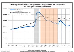 Development of Population since 1875 within the Current Boundaries (Blue Line: Population; Dotted Line: Comparison to Population Development of Brandenburg state; Grey Background: Time of Nazi rule; Red Background: Time of Communist rule)
 -
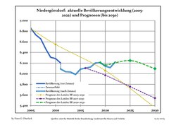 Recent Population Development and Projections (Population Development before Census 2011 (blue line); Recent Population Development according to the Census in Germany in 2011 (blue bordered line); Projections by the Brandenburg state for 2005-2030 (yellow line); for 2017-2030 (scarlet line), for 2020-2030 (green line)


|
|
|
Photo gallery
- Churches
-
 Blönsdorf
 -
 Mellnsdorf
 -
 Seehausen


See also
- Dennewitz
References
- ^ Landkreis Teltow-Fläming Wahl der Bürgermeisterin / des Bürgermeisters, accessed 4 July 2021.
- ^ "Bevölkerungsentwicklung und Bevölkerungsstandim Land Brandenburg Dezember 2022" (PDF). Amt für Statistik Berlin-Brandenburg (in German). June 2023.
- ^ Detailed data sources are to be found in the Wikimedia Commons.Population Projection Brandenburg at Wikimedia Commons
- v
- t
- e
Towns and municipalities in Teltow-Fläming
- Am Mellensee
- Baruth/Mark
- Blankenfelde-Mahlow
- Dahme
- Dahmetal
- Großbeeren
- Ihlow
- Jüterbog
- Luckenwalde
- Ludwigsfelde
- Niederer Fläming
- Niedergörsdorf
- Nuthe-Urstromtal
- Rangsdorf
- Trebbin
- Zossen

Authority control databases | |
|---|---|
| International |
|
| National |
|
 | This Brandenburg location article is a stub. You can help Wikipedia by expanding it. |
- v
- t
- e


