Oosterleek
Village in North Holland, Netherlands
52°38′18″N 5°11′51″E / 52.63833°N 5.19750°E / 52.63833; 5.19750 (2021)[1]
1609[1]
Oosterleek is a village in the municipality of Drechterland, in the Dutch province North Holland. The village used to belong to the municipalities Venhuizen (1970–2006) and Wijdenes (pre-1970).
Oosterleek was first noted on a map in 1311 as Oesterleke, in which oester means "eastern" and leke means "stream". This name was supposedly a reference to the fact that the village was located to the east of a stream.[3] During the 17th century, it was a fishing village which was home to a population of about 500 people.[4]
Nowadays, a small bit of Oosterleek lays in the Markermeer, because the levee was moved westwards to guarantee full safety. It is said that this part included a church. The current church was built in 1694. The church was decommissioned in 1972, and is nowadays used for weddings, expositions and concerts. It is also home to local library.[4]
Gallery
-
 Wooden farm
 -
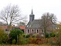 Church of Oosterleek


References
- ^ a b c "Kerncijfers wijken en buurten 2021". Central Bureau of Statistics. Retrieved 29 April 2022.
- ^ "Postcodetool for 1609GA". Actueel Hoogtebestand Nederland (in Dutch). Het Waterschapshuis. Retrieved 29 April 2022.
- ^ "Oosterleek - (geografische naam)". Etymologiebank (in Dutch). Retrieved 29 April 2022.
- ^ a b "Oosterleek". Plaatsengids (in Dutch). Retrieved 29 April 2022.
Wikimedia Commons has media related to Oosterleek.
- v
- t
- e
Populated places in the municipality of Drechterland
- Hem
- Hoogkarspel
- Oosterblokker
- Oosterleek
- Schellinkhout
- Venhuizen
- Westwoud
- Wijdenes


