Oudehaske
Village in Friesland, Netherlands
Oudehaske Aldehaske | |
|---|---|
Village | |
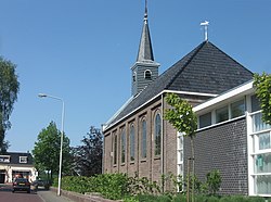 Oudehaske church | |
 Flag  Coat of arms | |
 Location in the former Skarsterlân municipality | |
52°57′21″N 5°52′20″E / 52.95583°N 5.87222°E / 52.95583; 5.87222 | |
| Country |  Netherlands Netherlands |
| Province |  Friesland Friesland |
| Municipality |  De Fryske Marren De Fryske Marren |
| Area | |
| • Total | 7.96 km2 (3.07 sq mi) |
| Elevation | 0.1 m (0.3 ft) |
| Population (2021)[1] | |
| • Total | 1,935 |
| • Density | 240/km2 (630/sq mi) |
| Postal code | 8465[1] |
| Dialing code | 0513 |
Oudehaske (West Frisian: Aldehaske) is a village in De Fryske Marren in the province of Friesland, the Netherlands. It had a population of around 1980 in 2017.[3]
History
The village was first mentioned in 1315 as Hasca. Haske is probably a type of grass. Oude (old) has been added to distinguish from Nijehaske.[4]
Oudehaske is a road village which developed on the Heerenveen to Joure main road. In the late 19th century, the former peat excavation areas were poldered.[5] In 1840, it was home to 585 people. The Protestant Church was built in 1906.[6] Oudehaske started to grow in the 1960s.[5]
Before 2014, Oudehaske was part of the Skarsterlân municipality and before 1984 it was part of Haskerland.[6]
Oudehaske is known in traffic engineering circles for the radical innovation in street design pioneered there by Hans Monderman, removing signs and using subtle cues to indicate that the roadways are shared space between pedestrians and other vehicles.[7]
Gallery
-
 Farm in Oudehaske
 -
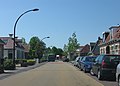 Street view
 -
 Nannewijd, lake near Oudehaske


References
- ^ a b c "Kerncijfers wijken en buurten 2021". Central Bureau of Statistics. Retrieved 29 March 2022.
- ^ "Postcodetool for 8465MA". Actueel Hoogtebestand Nederland (in Dutch). Het Waterschapshuis. Retrieved 29 March 2022.
- ^ Kerncijfers wijken en buurten 2017 - CBS
- ^ "Oudehaske - (geografische naam)". Etymologiebank (in Dutch). Retrieved 29 March 2022.
- ^ a b Ronald Stenvert & Sabine Broekhoven (2000). "Oudehaske" (in Dutch). Zwolle: Waanders. ISBN 90 400 9476 4. Retrieved 29 March 2022.
- ^ a b "Oudehaske". Plaatsengids (in Dutch). Retrieved 29 March 2022.
- ^ "Why Street Signs Make Traffic More Dangerous". Jalopnik. Retrieved 29 March 2022.
External links
![]() Media related to Oudehaske at Wikimedia Commons
Media related to Oudehaske at Wikimedia Commons
- v
- t
- e
Populated places in the municipality of De Fryske Marren
- Former municipalities: Gaasterlân-Sleat
- Lemsterland
- Skarsterlân
- Akmarijp
- Bakhuizen
- Balk
- Bantega
- Boornzwaag
- Broek
- Delfstrahuizen
- Dijken
- Doniaga
- Echten
- Echtenerbrug
- Eesterga
- Elahuizen
- Follega
- Goingarijp
- Harich
- Haskerhorne
- Idskenhuizen
- Kolderwolde
- Langweer
- Legemeer
- Mirns
- Nijehaske
- Nijemirdum
- Oldeouwer
- Oosterzee
- Oudega
- Oudehaske
- Oudemirdum
- Ouwster-Nijega
- Ouwsterhaule
- Rijs
- Rohel
- Rotstergaast
- Rotsterhaule
- Rottum
- Ruigahuizen
- Scharsterbrug
- Sint Nicolaasga
- Sintjohannesga
- Snikzwaag
- Sondel
- Terherne
- Terkaple
- Teroele
- Tjerkgaast
- Vegelinsoord
- Wijckel
 | This Friesland location article is a stub. You can help Wikipedia by expanding it. |
- v
- t
- e


