Oudenhoorn
Village in South Holland, Netherlands

Coat of arms
51°50′N 4°12′E / 51.833°N 4.200°E / 51.833; 4.200
(2021)[1]
3227[1]
Oudenhoorn is a village in the Dutch province of South Holland. It is part of the municipality of Voorne aan Zee and lies about 3 km east of Hellevoetsluis.
The village was first mentioned in 1356 as "den Hoorn". The current name means "old corner (of a dike)". The eponymous polder was created in 1356 by order of Machteld van Voorne. Oud (old) has been added to distinguish from Nieuwenhoorn.[3]
Oudenhoorn was an independent municipality until 1980 when it was merged into Bernisse. In 2015, it became part of Hellevoetsluis.[4]
Gallery
-
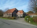 Farm in Oudenhoorn
 -
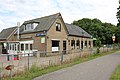 Former tram station. Nowadays pub
 -
 Street view
 -
 Farm in Oudenhoorn


References
- ^ a b c "Kerncijfers wijken en buurten 2021". Central Bureau of Statistics. Retrieved 3 May 2022.
- ^ "Postcodetool for 3227AA". Actueel Hoogtebestand Nederland (in Dutch). Het Waterschapshuis. 24 July 2019. Retrieved 3 May 2022.
- ^ "Oudenhoorn - (geografische naam)". Etymologiebank (in Dutch). Retrieved 3 May 2022.
- ^ "Oudenhoorn". Plaatsengids (in Dutch). Retrieved 3 May 2022.
Wikimedia Commons has media related to Oudenhoorn.
Authority control databases | |
|---|---|
| International |
|
| National |
|
- v
- t
- e


