Pimampiro Canton
Canton in Imbabura Province, Ecuador

Flag

Seal
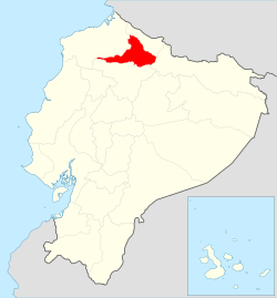
Location of Imbabura Province in Ecuador.
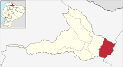
Cantons of Imbabura Province
 Ecuador
 (2022 census)[1]
Pimampiro Canton is a canton of Ecuador, located in Imbabura Province. Its population in the 2001 census was 12,951[2] and 12,970 in the 2010 census.[3]
Pimampiro is located in the Andes of northern Ecuador. Its capital is the town of Pimampiro which has an elevation of 2,163 metres (7,096 ft) above sea level.[4] Pimampiro has an area of 437 square kilometres (169 sq mi).
Demographics
Ethnic groups as of the Ecuadorian census of 2010:[5]
- Mestizo 73.4%
- Indigenous 13.5%
- Afro-Ecuadorian 10.2%
- White 2.6%
- Montubio 0.2%
- Other 0.1%
References
External links
- Map of Imbabura Province
- v
- t
- e
Cantons of Ecuador, by province- Antonio Ante
- Cotacachi
- Ibarra
- Otavalo
- Pimampiro
- San Miguel de Urcuquí
de los Tsáchilas
- Santo Domingo
- La Concordia
 Ecuador portal
 | This Ecuador location article is a stub. You can help Wikipedia by expanding it. |
- v
- t
- e


