Posto Santo
Civil parish in Azores, Portugal
38°40′42″N 27°13′51″W / 38.67833°N 27.23083°W / 38.67833; -27.23083 Portugal
Parish: fl. 1599
Civil parish: 15 September 1980
(2011)
9700-238
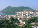
Posto Santo is a parish in the municipality of Angra do Heroísmo on the island of Terceira in the Azores. The population in 2011 was 1,048,[1] in an area of 20.37 km2.[2] Posto Santo was elevated to parish status on 15 September 1980. It was previously part of the parish of Santa Luzia. The parish is relatively far from the ocean, and it lies at an elevation of forty-five metres. Its predominant economic activity is agriculture. It contains the localities Espigão, Grota do Medo, Lapinha, Piquinho and Posto Santo.[3]
History
The name, "Posto Santo", is literally translated as "holy post", its origin developed from an outbreak of bubonic plague in 1599 that killed thousands on the island of Terceira. The parish of Posto Santo was spared and served as a refuge for many of the residents of Angra do Heroísmo. Since then, it has been known as Posto Santo.
Posto Santo should not be confused with Porto Santo which is an island close to Madeira Island.[3]
References
- v
- t
- e

- Altares
- Cinco Ribeiras
- Doze Ribeiras
- Feteira
- Nossa Senhora da Conceição
- Porto Judeu
- Posto Santo
- Raminho
- Ribeirinha
- Santa Bárbara
- Santa Luzia
- São Bartolomeu de Regatos
- São Bento
- São Mateus da Calheta
- São Pedro
- Sé
- Serreta
- Terra Chã
- Vila de São Sebastião
landmarks
- Algar do Carvão
- Bay of Angra
- Bay of Pontas
- Bay of Salga
- Bay of Refugo
- Cabras Islets
- Furna de Água
- Galerias da Feteira
- Gruta Brisa Azul
- Gruta das Agulhas
- Gruta das Cinco Ribeiras
- Gruta das Mercês
- Gruta do Zé Grande
- Gruta dos Ratões
- Lagoa do Negro
- Mata da Serreta
- Monte Brasil
- Parque de Campismo das Cinco Ribeiras
- Ponta do Queimado
- Porto das Cinco Ribeiras
- Prainha
- Serra da Ribeirinha
- Serra de Santa Bárbara
- Serra do Morião ou da Nasce Água
- Zona Balnear do Negrito
landmarks
- Bettencourt Palace
- Cais da Alfândega
- Cais da Silveira
- Castle of Moinhos
- Cemetery of Anchors
- Church of São Mateus da Calheta
- Convent of São Gonçalo
- Duke of Terceira Garden
- Fort of the Açougue
- Fort of the Cavalas
- Fort of the Church of São Mateus da Calheta
- Fort of Greta
- Fort of Má Ferramenta
- Fort of the Maré
- Fort of Negrito
- Fort of Santo António do Monte Brasil
- Fort of São João
- Fort of São João Baptista
- Forte das Caninas
- Forte das Cinco Ribeiras
- Forte da Salga
- Forte de Santa Catarina das Mós
- Forte de Santo António
- Forte de São Fernando
- Forte de São Francisco
- Forte de São Sebastião
- Forte do Terreiro
- Forte do Zimbreiro
- Fortress of São Mateus da Calheta
- Reducto da Salga
- Miradouro da Amoreira
- Miradouro da Ponta do Queimado
- Miradouro da Serreta
- Miradouro das Veredas
- Miradouro do Pico das Cruzinhas
- Miradouro do Pico Matias Simão
- Municipal Palace/Hall of Angra do Heroísmo
- Parque Arqueológico Subaquático da Baía de Angra do Heroísmo
- Parque de Campismo das Cinco Ribeiras
- Parque Municipal do Relvão (Angra do Heroísmo)
- Porto das Cinco Ribeiras
- Redoubt of Dois Paus
- Redoubt of Três Paus
- Manor of Madre de Deus
- Sé Cathedral of Angra do Heroísmo
 Category


