SEPTA Route 66
| Route 66 | ||||||||||||||||||||||||||||||||||||||||||||||||||||||||||||||||||||||||||||||||||||||||||||||||||||||||||||||||||||||||||||||||||||||||||||||||||||||||||||||||
|---|---|---|---|---|---|---|---|---|---|---|---|---|---|---|---|---|---|---|---|---|---|---|---|---|---|---|---|---|---|---|---|---|---|---|---|---|---|---|---|---|---|---|---|---|---|---|---|---|---|---|---|---|---|---|---|---|---|---|---|---|---|---|---|---|---|---|---|---|---|---|---|---|---|---|---|---|---|---|---|---|---|---|---|---|---|---|---|---|---|---|---|---|---|---|---|---|---|---|---|---|---|---|---|---|---|---|---|---|---|---|---|---|---|---|---|---|---|---|---|---|---|---|---|---|---|---|---|---|---|---|---|---|---|---|---|---|---|---|---|---|---|---|---|---|---|---|---|---|---|---|---|---|---|---|---|---|---|---|---|---|
| Frankford-Knights to Frankford Transportation Center | ||||||||||||||||||||||||||||||||||||||||||||||||||||||||||||||||||||||||||||||||||||||||||||||||||||||||||||||||||||||||||||||||||||||||||||||||||||||||||||||||
 | ||||||||||||||||||||||||||||||||||||||||||||||||||||||||||||||||||||||||||||||||||||||||||||||||||||||||||||||||||||||||||||||||||||||||||||||||||||||||||||||||
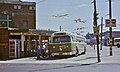
 Route 66 trackless trolley on the 7300 block of Frankford Avenue | ||||||||||||||||||||||||||||||||||||||||||||||||||||||||||||||||||||||||||||||||||||||||||||||||||||||||||||||||||||||||||||||||||||||||||||||||||||||||||||||||
| Overview | ||||||||||||||||||||||||||||||||||||||||||||||||||||||||||||||||||||||||||||||||||||||||||||||||||||||||||||||||||||||||||||||||||||||||||||||||||||||||||||||||
| System | Frankford District[1] | |||||||||||||||||||||||||||||||||||||||||||||||||||||||||||||||||||||||||||||||||||||||||||||||||||||||||||||||||||||||||||||||||||||||||||||||||||||||||||||||
| Operator | SEPTA City Transit Division | |||||||||||||||||||||||||||||||||||||||||||||||||||||||||||||||||||||||||||||||||||||||||||||||||||||||||||||||||||||||||||||||||||||||||||||||||||||||||||||||
| Began service | 1955 (1955) (trackless trolleys) | |||||||||||||||||||||||||||||||||||||||||||||||||||||||||||||||||||||||||||||||||||||||||||||||||||||||||||||||||||||||||||||||||||||||||||||||||||||||||||||||
| Route | ||||||||||||||||||||||||||||||||||||||||||||||||||||||||||||||||||||||||||||||||||||||||||||||||||||||||||||||||||||||||||||||||||||||||||||||||||||||||||||||||
| Locale | Philadelphia | |||||||||||||||||||||||||||||||||||||||||||||||||||||||||||||||||||||||||||||||||||||||||||||||||||||||||||||||||||||||||||||||||||||||||||||||||||||||||||||||
| Communities served | Northeast Philadelphia | |||||||||||||||||||||||||||||||||||||||||||||||||||||||||||||||||||||||||||||||||||||||||||||||||||||||||||||||||||||||||||||||||||||||||||||||||||||||||||||||
| Start | Frankford Transportation Center | |||||||||||||||||||||||||||||||||||||||||||||||||||||||||||||||||||||||||||||||||||||||||||||||||||||||||||||||||||||||||||||||||||||||||||||||||||||||||||||||
| Via | Frankford Avenue | |||||||||||||||||||||||||||||||||||||||||||||||||||||||||||||||||||||||||||||||||||||||||||||||||||||||||||||||||||||||||||||||||||||||||||||||||||||||||||||||
| End | Frankford Avenue & Knights Road (City Line Loop) | |||||||||||||||||||||||||||||||||||||||||||||||||||||||||||||||||||||||||||||||||||||||||||||||||||||||||||||||||||||||||||||||||||||||||||||||||||||||||||||||
| Length | 6.1 miles (9.8 km) | |||||||||||||||||||||||||||||||||||||||||||||||||||||||||||||||||||||||||||||||||||||||||||||||||||||||||||||||||||||||||||||||||||||||||||||||||||||||||||||||
| Service | ||||||||||||||||||||||||||||||||||||||||||||||||||||||||||||||||||||||||||||||||||||||||||||||||||||||||||||||||||||||||||||||||||||||||||||||||||||||||||||||||
| Ridership | 8,950 (2019 weekday average)[1] | |||||||||||||||||||||||||||||||||||||||||||||||||||||||||||||||||||||||||||||||||||||||||||||||||||||||||||||||||||||||||||||||||||||||||||||||||||||||||||||||
| Annual patronage | 2,607,562 (FY2019) | |||||||||||||||||||||||||||||||||||||||||||||||||||||||||||||||||||||||||||||||||||||||||||||||||||||||||||||||||||||||||||||||||||||||||||||||||||||||||||||||
| Timetable | Route 66 schedule | |||||||||||||||||||||||||||||||||||||||||||||||||||||||||||||||||||||||||||||||||||||||||||||||||||||||||||||||||||||||||||||||||||||||||||||||||||||||||||||||
| ||||||||||||||||||||||||||||||||||||||||||||||||||||||||||||||||||||||||||||||||||||||||||||||||||||||||||||||||||||||||||||||||||||||||||||||||||||||||||||||||


SEPTA Route 66 is a trackless trolley route in Northeast Philadelphia, Pennsylvania, United States. It connects the Market–Frankford Line at the Frankford Transportation Center to Wissinoming, Mayfair, Holmesburg, and Torresdale along Frankford Avenue, which is US 13 and includes the historic, colonial Frankford Avenue Bridge.
Route description
The route's eastern terminus is at City Line Loop, located at Frankford Avenue and Knights Road in Morrell Park. However, some weekday trips are truncated to Gregg Loop, located at Gregg Street and Frankford Avenue. Some weekday rush hour service begin/end at Frankford and Cottman Ave in the city's Mayfair neighborhood.[2]
The route is operated by trolleybuses, locally called trackless trolleys. Buses replaced streetcars (trolley cars) on July 30, 1955 and ran for one month then on September 1, 1955, the new Trackless Trolleys replace the buses.[3] The last day of streetcar operation was actually July 30, 1955, but diesel buses were temporarily used for six weeks.[3]
Diesel buses were substituted beginning June 2002 because of reconstruction of Frankford Depot (garage) and the adjacent Market-Frankford "El" viaduct and station,[3] but trackless service was restored in April 2008.[4][5]
All of the vehicles currently in use are ADA-compliant and equipped with bicycle racks. "Night Owl" service is also available, and rush hour service includes both local and express trips.
See also
 Buses portal
 Philadelphia portal


Gallery
-
 An older trackless trolley loading on route 66 in 1978

References
- ^ a b "SEPTA Route Statistics 2018" (PDF). SEPTA. Retrieved September 2, 2019.
- ^ "Route 66" (PDF). SEPTA. Retrieved September 3, 2019.
- ^ a b c Springirth, Kenneth C. (2008). Southeastern Pennsylvania Trolleys, pp. 10 and 115–116. Charleston, SC (US): Arcadia Publishing. ISBN 978-0-7385-5692-5.
- ^ Trolleybus Magazine No. 280 (July–August 2008), p. 95. National Trolleybus Association (UK). ISSN 0266-7452.
- ^ "Route of the Week - 66". iseptaphilly.com. Retrieved 2017-07-16.
External links
- SEPTA Route 66 (Official schedule and map)
- Flickr Photo
| |||||||||||||
|---|---|---|---|---|---|---|---|---|---|---|---|---|---|
| SEPTA Metro |
| ||||||||||||
| Regional Rail |
| ||||||||||||
| Buses and trolleybuses |
| ||||||||||||
| Miscellaneous | |||||||||||||


