San Benedetto Po
Comune in Lombardy, Italy
San Benedetto Po San Banadèt (Emilian) | |
|---|---|
Comune | |
| Comune di San Benedetto Po | |
 | |
 Coat of arms | |
Location of San Benedetto Po  | |
45°2′N 10°55′E / 45.033°N 10.917°E / 45.033; 10.917 | |
| Country | Italy |
| Region | Lombardy |
| Province | Mantua (MN) |
| Frazioni | Bardelle Camatta, Brede, Mirasole, Portiolo, San Siro, Zovo |
| Government | |
| • Mayor | Roberto Lasagna |
| Area | |
| • Total | 69.6 km2 (26.9 sq mi) |
| Elevation | 19 m (62 ft) |
| Population (31 December 2021)[2] | |
| • Total | 6,716 |
| • Density | 96/km2 (250/sq mi) |
| Demonym | Sambenedettini |
| Time zone | UTC+1 (CET) |
| • Summer (DST) | UTC+2 (CEST) |
| Postal code | 46027 |
| Dialing code | 0376 |
| Patron saint | St. Benedict |
| Website | Official website |
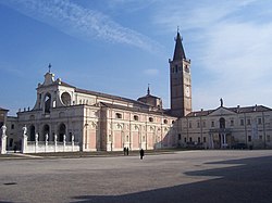
San Benedetto Po (Lower Mantovano: San Banadèt) is a comune (municipality) in the Province of Mantua in the Italian region Lombardy, located about 150 kilometres (93 mi) southeast of Milan and about 15 kilometres (9 mi) southeast of Mantua. It is one of I Borghi più belli d'Italia ("The most beautiful villages of Italy").[3] It is best known as the location of the Polirone Abbey.
References
- ^ "Superficie di Comuni Province e Regioni italiane al 9 ottobre 2011". Italian National Institute of Statistics. Retrieved 16 March 2019.
- ^ "Popolazione Residente al 1° Gennaio 2018". Italian National Institute of Statistics. Retrieved 16 March 2019.
- ^ "Lombardia" (in Italian). Retrieved 31 July 2023.
- v
- t
- e
- Acquanegra sul Chiese
- Asola
- Bagnolo San Vito
- Bigarello
- Borgo Mantovano
- Borgo Virgilio
- Borgocarbonara
- Bozzolo
- Canneto sull'Oglio
- Casalmoro
- Casaloldo
- Casalromano
- Castel Goffredo
- Castel d'Ario
- Castelbelforte
- Castellucchio
- Castiglione delle Stiviere
- Cavriana
- Ceresara
- Commessaggio
- Curtatone
- Dosolo
- Gazoldo degli Ippoliti
- Gazzuolo
- Goito
- Gonzaga
- Guidizzolo
- Magnacavallo
- Mantua
- Marcaria
- Mariana Mantovana
- Marmirolo
- Medole
- Moglia
- Monzambano
- Motteggiana
- Ostiglia
- Pegognaga
- Piubega
- Poggio Rusco
- Pomponesco
- Ponti sul Mincio
- Porto Mantovano
- Quingentole
- Quistello
- Redondesco
- Rivarolo Mantovano
- Rodigo
- Roncoferraro
- Roverbella
- Sabbioneta
- San Benedetto Po
- San Giacomo delle Segnate
- San Giorgio di Mantova
- San Giovanni del Dosso
- San Martino dall'Argine
- Schivenoglia
- Sermide e Felonica
- Serravalle a Po
- Solferino
- Sustinente
- Suzzara
- Viadana
- Villimpenta
- Volta Mantovana
Authority control databases | |
|---|---|
| International |
|
| National |
|
| Geographic |
|
 | This article on a location in the Province of Mantua is a stub. You can help Wikipedia by expanding it. |
- v
- t
- e


