San Fior
Comune in Veneto, Italy
Location of San Fior

45°54′N 12°23′E / 45.900°N 12.383°E / 45.900; 12.383
(Dec. 2004)[2]
31020
San Fior is a comune (municipality) in the Province of Treviso in the Italian region Veneto, located about 50 kilometres (31 mi) north of Venice and about 30 kilometres (19 mi) northeast of Treviso. As of 31 December 2004, it had a population of 6,357 and an area of 17.8 square kilometres (6.9 sq mi).[3]
San Fior borders the following municipalities: Codogné, Colle Umberto, Conegliano, Godega di Sant'Urbano, San Vendemiano.
Frazioni
San Fior is divided into three villages: the principal town is San Fior (or San Fior di Sopra); the south frazione is San Fior di Sotto and the north frazione is Castello Roganzuolo.
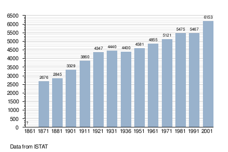
Demographic evolution
Twin towns
San Fior is twinned with:
 Colayrac-Saint-Cirq, France

References
- ^ "Superficie di Comuni Province e Regioni italiane al 9 ottobre 2011". Italian National Institute of Statistics. Retrieved 16 March 2019.
- ^ "Popolazione Residente al 1° Gennaio 2018". Italian National Institute of Statistics. Retrieved 16 March 2019.
- ^ All demographics and other statistics: Italian statistical institute Istat.
- v
- t
- e

- Altivole
- Arcade
- Asolo
- Borso del Grappa
- Breda di Piave
- Caerano di San Marco
- Cappella Maggiore
- Carbonera
- Casale sul Sile
- Casier
- Castelcucco
- Castelfranco Veneto
- Castello di Godego
- Cavaso del Tomba
- Cessalto
- Chiarano
- Cimadolmo
- Cison di Valmarino
- Codognè
- Colle Umberto
- Conegliano
- Cordignano
- Cornuda
- Crocetta del Montello
- Farra di Soligo
- Follina
- Fontanelle
- Fonte
- Fregona
- Gaiarine
- Giavera del Montello
- Godega di Sant'Urbano
- Gorgo al Monticano
- Istrana
- Loria
- Mansuè
- Mareno di Piave
- Maser
- Maserada sul Piave
- Meduna di Livenza
- Miane
- Mogliano Veneto
- Monastier di Treviso
- Monfumo
- Montebelluna
- Morgano
- Moriago della Battaglia
- Motta di Livenza
- Nervesa della Battaglia
- Oderzo
- Ormelle
- Orsago
- Paese
- Pederobba
- Pieve del Grappa
- Pieve di Soligo
- Ponte di Piave
- Ponzano Veneto
- Portobuffolé
- Possagno
- Povegliano
- Preganziol
- Quinto di Treviso
- Refrontolo
- Resana
- Revine Lago
- Riese Pio X
- Roncade
- Salgareda
- San Biagio di Callalta
- San Fior
- San Pietro di Feletto
- San Polo di Piave
- San Vendemiano
- San Zenone degli Ezzelini
- Santa Lucia di Piave
- Sarmede
- Segusino
- Sernaglia della Battaglia
- Silea
- Spresiano
- Susegana
- Tarzo
- Trevignano
- Treviso
- Valdobbiadene
- Vazzola
- Vedelago
- Vidor
- Villorba
- Vittorio Veneto
- Volpago del Montello
- Zenson di Piave
- Zero Branco
| Authority control databases |
|
|---|
 | This article on a location in Veneto is a stub. You can help Wikipedia by expanding it. |
- v
- t
- e


