Sandwich Harbour
Former harbour on the Namibian Atlantic coast
23°22′S 14°29′E / 23.367°S 14.483°E / -23.367; 14.483 Ramsar Wetland
Sandwich Harbour (Portuguese: Porto d'Ilhéu), also known as Sandwich Bay, Sandvishawe, Sandvisbaai and Sandfisch Bai is an area on the Atlantic coast of Namibia that includes a bay in the north and a lagoon at the southern end.[2] Sandwich Harbour might have been named after an English whaling ship, the Sandwich, which worked during the 1780s, or the name may be a corruption of the German word "sandfische", a species of shark found in the area.[3] Formerly, the bay was a moderately-sized commercial port based around whaling and small-scale fishing, but it is now best known for its birdlife in the lagoon to the south of the bay.
Geography
Located about 80 km south of Walvis Bay, the area is within the Erongo Region. The bay opens to the north and is about 4.2 km long and 4 km wide. There is a shallow lagoon lying south of the bay, separated from it by an area of beach ridges and swales with saltpans.
The lagoon is 3.7 km in length and 1 km wide and is enveloped by sandy desert on its eastern side.[4] Former visitors to the area assumed that the water in the lagoon was fresh, but a recent survey found out that the lagoon is filled with poor quality brackish water that seeps under the dunes and allows the growth of large reed beds at the water's edge.[citation needed]
Sandwich Harbour was declared a Ramsar Site on 23 August 1995.

History
The area was surveyed in the 1880s by the Royal Navy, but it was considered very inferior to Walvis Bay and no development took place. Occasional sealing vessels used the bay as an anchorage instead of Walvis Bay, and there were some temporary settlements used by seasonal fishermen catching snoek (Thyrsites atun).
In the 1930s, an ambitious project was started to build a guano island in the lagoon using sand pumps imported from the Netherlands. Unfortunately, jackals could cross to the island at low tide and chase the birds away. All that remains of the project is the manager's house.
Currently, the bay and lagoon are within the Namib-Naukluft National Park. To enter, visitors need a permit, which can be obtained from the office of the Ministry of Environment and Tourism in Swakopmund. The fauna was surveyed by the South African Museum and the National Museum of Namibia. It was found that the fauna was totally marine.[5]
Gallery
-
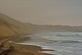
 The Sandwich Harbour seen from atop a sand dune
 -
 The Namibian desert's edge at Sandwich Harbour
 -
 The road leading to Sandwich Harbour
 -
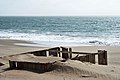 Remains of the guanu factory
 -
 Aerial view of the Sandwich Harbour


See also
References
External links
 Media related to Sandwich Harbour at Wikimedia Commons
- First confirmed record of Lithognathus lithognathus sympatric with L. aureti
- v
- t
- e
African seas
and seas
and bays
- Abu Qir Bay
- Acheïl Dakhlet
- Al Hoceima Bay
- Algiers Bay
- Algoa Bay
- Ambas Bay
- Ana Chaves Bay
- Angra de Cintra
- Antongil Bay
- Antsiranana Bay
- Arab's Gulf
- Baía Almeida
- Baía da Condúcia
- Baía da Corimba
- Baía de Mocambo
- Baía de Mossuril
- Baia de Porto Amboim
- Baía de Santa Marta
- Baía de Sucujaque
- Baía de Tombua
- Baía do Ambriz
- Baía do Bengo
- Baía do Dande
- Baía do Govuro
- Baía do Lúrio
- Baía do Nzeto
- Baía do Suto
- Baie de Gorée
- Baie de Sangareya
- Baie de Yof
- Bandombaai
- Bay of Anfile
- Bay of Arguin
- Bay of Aseb
- Bay of Arzew
- Bight of Benin
- Bay of Beylul
- Bay of Edd
- Bay of Hawakil
- Bay of Langarano
- Bay of Saint-Augustin
- Bay of Tangier
- Benguela Bay
- Bera’esoli
- Betty’s Bay
- Bight of Biafra
- Bocock’s Bay
- Bombetoka Bay
- Bootbaai
- Bosluisbaai
- Cabinda Bay
- Cape Cross Bay
- Cape Negro Bay
- Chake-Chake Bay
- Chameis Bay
- Chwaka Bay
- Conception Bay
- Cuio Bay
- Dakhlet Nouadhibou
- Dalwakteah Bay
- Deurloopbaai
- Doringbaai
- Dungonab Bay
- Durissa Bay
- Elands Bay
- Enseada das Pombas
- Enseada de São Braz
- Enseada do Catumbo
- Enseada do Chalungo
- Enseada do Quicombo
- Enseada do Quitungo
- Enseada dos Três Irmãos
- Equimina Bay
- False Bay
- Farta Bay
- Fernao Veloso Bay
- Foul Bay
- Frederik se Baai
- Grosse Bucht
- Gulf of Aden
- Gulf of 'Agig
- Gulf of Gabès
- Gulf of Guinea
- Gulf of Hammamet
- Gulf of Sirte
- Gulf of Suez
- Gulf of Tadjoura
- Gulf of Tunis
- Gulf of Zula
- Ghoubbet-el-Kharab
- Hafun Bay South
- Hann Bay
- Harrison Cove
- Henties Bay
- Hirghīgo Bahir Selat’ē
- Horingbaai
- Hottentotsbaai
- Hurdiyo
- Hydra Bay
- Inhambane Bay
- Jammer Bucht
- John Owen Bay
- Kalawy Bay
- Kiwaiyu Bay
- Lambert Bay
- Lamu Bay
- Langbaai
- Loango Bay
- Lobito Bay
- Luanda Bay
- Lüderitz Bay
- McDougall Bay
- Manza Bay
- Maputo Bay
- Markusbaai
- Memba Bay
- Menai Bay
- Meob Bay
- Mietjie Frans se Baai
- Moraha Bahir Selat’ē
- Mossel Bay
- Möwebaai
- Namibe Bay
- Noopbaai
- Oran Gulf
- Pemba Bay
- Pipas Bay
- Platbaai
- Plaatjieskraalbaai
- Plettenbergbaai
- Pointe-Noire Bay
- Porto Alexandre, Angola
- Prinzen Bucht
- Río de Oro Bay
- Rock Bay
- Roode Bay
- Rooiwalbaai
- Saint Francis Bay
- Saint Francis Bay (Eastern Cape)
- St Helena Bay
- Saint Sebastian Bay
- Saldanha Bay
- Sandwich Harbour
- Sierra Bay
- Skoonbergbaai
- Skurfbaai
- Slangbaai
- Sodwana Bay
- Sofala Bay
- Somnaasbaai
- Spencer Bay
- Struisbaai
- Spoegrivierbaai
- Swartstraat
- Table Bay
- Thysbaai
- Tietiesbaai
- Ungama Bay
- Walker Bay
- Walvis Bay (bay)
- Yawri Bay
- Bab-el-Mandeb
- Bab Iskender
- Canal de Bolama
- Canal de Bolola
- Canal de Caió
- Canal de São Vicente
- Canal do Meio
- Mafia Channel
- Massawa Channel
- Mozambique Channel
- Tigres Strait
- Pemba Channel
- Shubuk Channel
- Guardafui Channel
- Strait of Gibraltar
- Strait of Sicily
- Straits of Tiran
- Zanzibar Channel
seas
 Africa portal
  Oceans portal
| Authority control databases: National |
|
|---|
 | This Namibia location article is a stub. You can help Wikipedia by expanding it. |
- v
- t
- e


