Sant'Angelo Muxaro
You can help expand this article with text translated from the corresponding article in Italian. (January 2022) Click [show] for important translation instructions.
- Machine translation, like DeepL or Google Translate, is a useful starting point for translations, but translators must revise errors as necessary and confirm that the translation is accurate, rather than simply copy-pasting machine-translated text into the English Wikipedia.
- Do not translate text that appears unreliable or low-quality. If possible, verify the text with references provided in the foreign-language article.
- You must provide copyright attribution in the edit summary accompanying your translation by providing an interlanguage link to the source of your translation. A model attribution edit summary is
Content in this edit is translated from the existing Italian Wikipedia article at [[:it:Sant'Angelo Muxaro]]; see its history for attribution. - You may also add the template
{{Translated|it|Sant'Angelo Muxaro}}to the talk page. - For more guidance, see Wikipedia:Translation.
Comune in Sicily, Italy
Sant'Angelo Muxaro Sant'Àngilu Muxaru (Sicilian) | |
|---|---|
Comune | |
| Comune di Sant'Angelo Muxaro | |
 | |
 Coat of arms | |
Location of Sant'Angelo Muxaro  | |
37°28′15″N 13°32′47″E / 37.47083°N 13.54639°E / 37.47083; 13.54639 | |
| Country | Italy |
| Region | Sicily |
| Province | Agrigento (AG) |
| Government | |
| • Mayor | Angelo Tirrito |
| Area | |
| • Total | 64.55 km2 (24.92 sq mi) |
| Elevation | 335 m (1,099 ft) |
| Population (30 November 2016)[2] | |
| • Total | 1,330 |
| • Density | 21/km2 (53/sq mi) |
| Demonym | Santangelesi |
| Time zone | UTC+1 (CET) |
| • Summer (DST) | UTC+2 (CEST) |
| Postal code | 92020 |
| Dialing code | 0922 |
| Patron saint | St. Angelus of Jerusalem |
| Saint day | August 16 |
| Website | Official website |
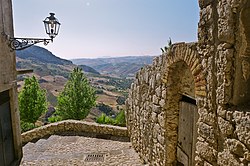
Sant'Angelo Muxaro (Italian: [sanˈtandʒelo muʃˈʃaːro]; Sicilian: Sant'Àngilu Muxaru or Musciaru, Arbëreshë Albanian: Shënt'Ëngjëlli) is a comune (municipality) in the Province of Agrigento in the Italian region of Sicily, located about 70 kilometres (43 mi) south of Palermo and about 20 kilometres (12 mi) north of Agrigento. The town was founded and historically inhabited by the Arbëreshë community.[3]
History
The early urban origins of this territory remain undefined. An important Iron Age village arose around the 13th century BC by indigenous people, identified with the Sicani . Archaeologically the village constitutes a valid chronological guide for local production of objects from the first native societies to the relationship with the first Greek settlers during the great season of the apoikiai during the 8th - 7th century BC.[4]
The town is sitting atop of a hill, partially excavated. To this day a small part has revealed a collection of small and big tombs, varying in size, carved in soft stone. In it proximity many small necropolises can be found.
Four gold and silver bowls dating from 650 to 600 BC were found in a tomb in the vicinity of the village in the 18th century, by Paolo Orsi. Only one gold bowl remains, now in the British Museum's collection. The BM's phiale is decorated with 6 striding bulls and has become a symbol of Sant'Angelo Muxaro.[5] The Archeological Museum of Agrigento, adjacent to the Valley of the Temples, holds a selection of vases found in the vicinity of the village, mainly inside tombs.
Following the Ottoman invasion of Albania in the late fifteenth century, the present town was colonized by Albanian refugees. The centre of the town was founded in 1506[6] with further building in 1511. The town retained a distinct Italo-Albanian or Arbëreshë culture for many years. In the early 17th century the town was still an Arbëreshë settlement but now the Arbëresh language has disappeared from usage.
In 1600, the barony was acquired by the Princes of Castelvetrano, D'Aragona and Tagliavia and finally came under the jurisdiction of Pignatelli, Dukes of Monteleone, who kept it until 1812, when feudalism was suppressed in Sicily.
Geography
Sant'Angelo Muxaro borders the following municipalities: Agrigento, Alessandria della Rocca, Aragona, Casteltermini, Cattolica Eraclea, Cianciana, Raffadali, San Biagio Platani, Santa Elisabetta.
References
- ^ "Superficie di Comuni Province e Regioni italiane al 9 ottobre 2011". Italian National Institute of Statistics. Retrieved 16 March 2019.
- ^ All demographics and other statistics: Italian statistical institute Istat.
- ^ P. Bruni, ed. (2004). Arbëreshë: cultura e civiltà di un popolo. p. 34. ISBN 9788824020091.
- ^ "Sant'Angelo Muxaro", Wikipedia (in Italian), 2024-03-28, retrieved 2024-03-28
- ^ British Museum Collection
- ^ "Sant'Angelo Muxaro (AG)".
External links
- Official website
- v
- t
- e
- Agrigento
- Alessandria della Rocca
- Aragona
- Bivona
- Burgio
- Calamonaci
- Caltabellotta
- Camastra
- Cammarata
- Campobello di Licata
- Canicattì
- Casteltermini
- Castrofilippo
- Cattolica Eraclea
- Cianciana
- Comitini
- Favara
- Grotte
- Joppolo Giancaxio
- Lampedusa e Linosa
- Licata
- Lucca Sicula
- Menfi
- Montallegro
- Montevago
- Naro
- Palma di Montechiaro
- Porto Empedocle
- Racalmuto
- Raffadali
- Ravanusa
- Realmonte
- Ribera
- Sambuca di Sicilia
- San Biagio Platani
- San Giovanni Gemini
- Sant'Angelo Muxaro
- Santa Elisabetta
- Santa Margherita di Belice
- Santo Stefano Quisquina
- Sciacca
- Siculiana
- Villafranca Sicula
Authority control databases | |
|---|---|
| International |
|
| National |
|
| Geographic |
|
| Other |
|
 | This Sicilian location article is a stub. You can help Wikipedia by expanding it. |
- v
- t
- e


